

You are here
Avalanche Forecast for 2020-01-10 05:43
- EXPIRED ON January 11, 2020 @ 5:43 amPublished on January 10, 2020 @ 5:43 am
- Issued by Nick Meyers - Shasta-Trinity National Forest
Bottom Line
Beginning tonight, a series of winter storms will impact the area over the next several days. Expect increased avalanche hazard as new snow combines with gusty winds. Anticipate wind drifted snow in exposed areas near and above treeline. Use caution where wind slabs have formed on slopes steeper than 30 degrees. LOW danger today will rise to MODERATE late tonight, after the storm onset.


Avalanche Problem 1: Wind Slab
-
Character ?

-
Aspect/Elevation ?
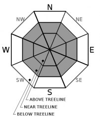
-
Likelihood ?CertainVery LikelyLikelyPossible
 Unlikely
 -
Size ?HistoricVery LargeLargeSmall

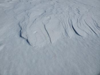
A variety of smooth, icy snow surfaces exist near and above treeline providing a good bed surface for avalanches, however we've yet to see any significant slabs sticking to notable avalanche terrain, yet. Small, easterly facing test slopes produced shooting cracks and very small, propagating slabs within the top couple inches of snow yesterday. Additional snow and wind will allow for more drifting and wind slab formation tonight... it's just a matter of whether the snow sticks to any slopes steeper than 30 degrees or not. Currently, most if not all avalanche terrain of consequence is scoured to the 12/19 ice crust. Pay closest attention near treeline where wind speeds may be lesser and wind loading is at it's best.
Identify where wind slabs may exist and move around them with caution, especially if on slopes steeper than 35 degrees. You'll know when you seen them...areas of scoured, crusty and icy snow will be immediately followed by wind drifted snow, small cornices, hollow wind pillows. Remember, surface cracking is a sign of unstable snow. Be sure to always communicate within your group about what your are seeing and proper route choice. Pick good partners because they are your rescue party.
Forecast Discussion
Tomorrow is the MSAC's annual motorized specific, avalanche awareness and companion rescue workshop. Meet at the Forest Service ranger station in Mount Shasta at 9am, 204 W Alma Street. No sign up necessary. Click HERE for more info.
Check out the Throttle Decision video series HERE or click the video introduction below.
Recent Observations
A short-lived storm blew through early yesterday morning and brought 4-7 inches of low density snow to areas above 6,500 feet on Mount Shasta. The new snow struggled to stick to and/or wind load on a steep enough slope for an avalanche to occur.
Below treeline: 4-6 inches of new snow was evenly distributed and wind affect minimal. Crust layers below could still be felt on skis. The 12/19 ice layer is less discernable at lower elevations. No avalanche concerns were observed.
Near Treeline: 5-7 inches of low density new snow. Westerly wind affect becomes noticeable, switching to southeast during PM hours. Still somewhat even distribution of new snow in protected areas but some localized windy terrain hosted scouring. Small test slopes produced shooting cracks and small slab failures within top 2 inches of new snow. Low angle gullies and wind eddies behind rocks/trees held hollow wind drifts up to 2 feet deep.
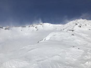
Above Treeline: Windy, primarily out of the west but localized swirling and eddies observed wind out of the south and east as well. All slopes steeper than +/- 25 degrees were scoured and wind stripped down to the 12/19 ice layer. Low angle gullies and leeward areas behind exposed rocks held drifts up to 2 feet deep. No wind loading was observed in avalanche terrain. Smooth, icy surfaces along ridgelines and moraine tops remain. Some shallow buried rocks still exist.
Weather and Current Conditions
Weather Summary
Look for increasing clouds over the course of the day. A winter storm is set to impact the area this evening and through the weekend. The first round of rain and snow will push inland tonight into Saturday morning. The next will arrive Sunday morning. Monday, more precip will be on the way, likely during the later part of the day/evening. Snow levels throughout the storm(s) will remain 3,600 feet or lower. Expect gusty, erratic winds near and above treeline. By close of weekend business, we could see a pretty nice blanket of fresh snow in the mountains...Yee-haw!
24 Hour Weather Station Data @ 4:00 AM
| Weather Station | Temp (°F) | Wind (mi/hr) | Snow (in) | Comments | ||||||||
|---|---|---|---|---|---|---|---|---|---|---|---|---|
| Cur | Min | Max | Avg | Avg | Max Gust | Dir | Depth | New | Water Equivalent | Settlement | ||
| Mt. Shasta City (3540 ft) | 24 | 24 | 40 | 33 | 3 | N | ||||||
| Sand Flat (6750 ft) | 22 | 20 | 26 | 23 | 41 | 0 | 0 | 0 | ||||
| Ski Bowl (7600 ft) | 23.5 | 19 | 32.5 | 22.5 | 47.2 | 0 | 0 | .5 | ||||
| Gray Butte (8000 ft) | 29.5 | 17.5 | 29.5 | 20.5 | 7 | 37 | SSE | |||||
| Castle Lake (5870 ft) | 0 | 0 | 0 | 0 | 0 | 0 | 0 | down | ||||
| Mount Eddy (6509 ft) | 26.5 | 21.5 | 27 | 23.5 | 2 | 11 | SE | 34.6 | 0 | 0 | ||
| Ash Creek Bowl (7250 ft) | down | |||||||||||
| Ash Creek Ridge (7895 ft) | down |
Two Day Mountain Weather Forecast
Produced in partnership with the Medford NWS
| For 7000 ft to 9000 ft | |||
|---|---|---|---|
|
Friday (4 a.m. to 10 p.m.) |
Friday Night (10 p.m. to 4 a.m.) |
Saturday (4 a.m. to 10 p.m.) |
|
| Weather | Partly cloudy, snow after 4pm. Chance of precipitation 80%. Snow levels starting at 4,500 feet and lowering to 3,500 feet. | Snow, breezy. Chance of precipitation 100%. Snow level near 3,600 feet. | Snow showers. Blustery. Chance of precipitation 90%. Snow levels near 3,600 feet. |
| Temperature (°F) | 35 | 23 | 28 |
| Wind (mi/hr) | Southwest 10-15 | Southwest 10-15 | West 10-15 |
| Precipitation SWE / Snowfall (in) | 0.06 / 0-0.50 | 0.16 / 2-4 | 0.06 / 1-3 |
| For 9000 ft to 11000 ft | |||
| Friday | Friday Night | Saturday | |
| Weather | Increasing clouds, temperature rising to near 27 F by noon, then falling to 17 F. Windy. | Snow. Windy. | Snow showers, windy. |
| Temperature (°F) | 27 | 7 | 19 |
| Wind (mi/hr) | Northwest 20-30 | Southwest 30-40 | West 30-40 |
| Precipitation SWE / Snowfall (in) | 0.06 / 0-0.50 | 0.16 / 4-8 | 0.06 / 2-4 |
Season Precipitation for Mount Shasta City
| Period | Measured (in) | Normal (in) | Percent of Normal (%) |
|---|---|---|---|
| From Oct 1, 2025 (the wet season) | 9.35 | 17.35 | 54 |
| Month to Date (since Jul 1, 2026) | 0.42 | 2.14 | 20 |
| Year to Date (since Jan 1, 2026) | 0.42 | 2.14 | 20 |

