

You are here
Avalanche Forecast for 2020-01-13 06:45
- EXPIRED ON January 14, 2020 @ 6:45 amPublished on January 13, 2020 @ 6:45 am
- Issued by Ryan Sorenson - Mount Shasta Avalanche Center
Bottom Line
LOW danger this morning will rise to MODERATE this afternoon following the onset of a cold winter storm tracking toward the area. Human-triggered wind slab and storm slab avalanches are possible today. Active weather is forecast to continue throughout the week.


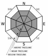
Avalanche Problem 1: Wind Slab
-
Character ?

-
Aspect/Elevation ?
-
Likelihood ?CertainVery LikelyLikelyPossible
 Unlikely
 -
Size ?HistoricVery LargeLargeSmall

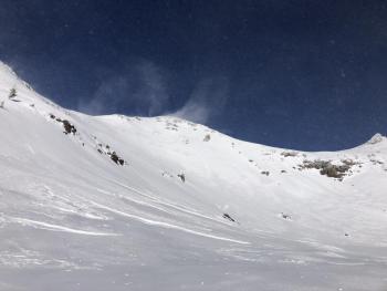
Significant snowfall is forecast this afternoon accompanied by strong southwest wind. In the next 24 hours, 4 to 8 inches of snow may fall above 3,500 feet. A variety of smooth, icy snow surfaces exist near and above treeline that could provide a good bed surface for avalanches. Avalanche danger will rise to a heightened level this afternoon. Human-triggered wind slab avalanches large enough to bury, injure, or kill a person are possible tonight. Evaluate snow and terrain carefully.
Fresh wind slabs are expected to form primarily on NW-N-NE-E-SE aspects but mountain winds can be variable so pay attention to where leeward areas reside. Stay away from steep slopes that have been loaded. Signs that wind slabs may be nearby are: shooting cracks, blocking, whumphing, convex pillows of wind-drifted snow, chalky, hollow sounding snow.
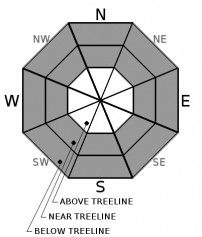
Avalanche Problem 2: Storm Slab
-
Character ?

-
Aspect/Elevation ?
-
Likelihood ?CertainVery LikelyLikelyPossible
Unlikely
-
Size ?HistoricVery LargeLargeSmall
Temperatures will increase throughout the day as warmer air moves around the storm system. New heavy snow could fall atop colder snow and create the potential for storm slab avalanches. This problem will be short lived and storm slab avalanches will remain small, but be aware of this hazard today when traveling near and below treeline.
Forecast Discussion
A winter weather advisory is in effect from 4 AM today until 10 AM tomorrow.
If you venture out, keep in mind the 5 red flags indicating avalanche danger:
- Recent avalanche activity.
- Cracking, blocking or whumphing of the snow pack.
- Significant snowfall in 24 hours.
- Strong winds.
- Rising temperatures.
Recent Observations
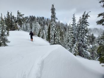
Misty and cold conditions were felt on Gray Butte yesterday. Low clouds and fog rolled in after 10 AM. Very light snow showers were observed throughout the day. Small, isolated, wind slabs were encountered on east facing terrain near the top of Gray Butte. These were unreactive to ski cuts. Existing snow surfaces are variable. In protected areas below and near treeline, 1 to 7 inches of low density snow remains above a number of wind, and sun crusts. Hard wind packed snow, stastrugi, and scoured snow surfaces can be found above treeline and along ridgelines.
In the last 24 hours on Mount Shasta:
- Temperatures have ranged from 15 to 21 degrees F at 8,000 feet.
- Strong westerly winds have averaged 27 mi/hr, gusting up to 55 mi/hr at 8,000 feet.
- The height of snow (HS) at 7,600 feet was 46 inches.
Weather and Current Conditions
Weather Summary
A winter storm is set to impact the area this afternoon. Forecast models are showing that the first round of snow will push into the area after 10 AM. Strong winds out of the southwest will accompany the snow. Expect 4 to 8 inches of total snow accumulation by tomorrow morning with the majority of the snow falling late this afternoon. Snow levels will start around 1,500 feet then rise to 3,500 feet tonight as warmer air moves around the storm system.
Snow will taper off and become more showery in nature tomorrow morning. A brief lull with slight chances of snow showers will continue until Wednesday. Another significant winter storm will arrive Wednesday. Heavy snowfall and strong winds are expected. A winter storm watch is in effect from Wednesday afternoon through Thursday above 3,000 feet. The area could receive in excess of a foot of new snow by midday Thursday.
24 Hour Weather Station Data @ 5:00 AM
| Weather Station | Temp (°F) | Wind (mi/hr) | Snow (in) | Comments | ||||||||
|---|---|---|---|---|---|---|---|---|---|---|---|---|
| Cur | Min | Max | Avg | Avg | Max Gust | Dir | Depth | New | Water Equivalent | Settlement | ||
| Mt. Shasta City (3540 ft) | 26 | 22 | 34 | 29 | 1 | N | ||||||
| Sand Flat (6750 ft) | 21 | 19 | 29 | 24 | 40 | 0 | 0 | 0 | ||||
| Ski Bowl (7600 ft) | 19 | 17.5 | 25 | 20.5 | 46.5 | 0 | 0.01 | 0 | ||||
| Gray Butte (8000 ft) | 17 | 15.5 | 21.5 | 18 | 28 | 55 | NW | |||||
| Castle Lake (5870 ft) | down | |||||||||||
| Mount Eddy (6509 ft) | 20.5 | 18 | 29.5 | 23.5 | 2 | 15 | SE | 35.1 | 0 | 0 | ||
| Ash Creek Bowl (7250 ft) | down | |||||||||||
| Ash Creek Ridge (7895 ft) | down |
Two Day Mountain Weather Forecast
Produced in partnership with the Medford NWS
| For 7000 ft to 9000 ft | |||
|---|---|---|---|
|
Monday (4 a.m. to 10 p.m.) |
Monday Night (10 p.m. to 4 a.m.) |
Tuesday (4 a.m. to 10 p.m.) |
|
| Weather | Breezy. Partly cloudy then snow after 10 a.m. Chance of precipitation 90%. Snow levels near 1,500 feet and rising | Breezy. Snow showers in the evening then snow showers likely after midnight. Chance of precipitation 90%. Snow levels near 3,500 feet. | Mostly cloudy. Snow showers likely in the morning then chance of snow showers in the afternoon. Chance of precipitation 70% |
| Temperature (°F) | 28 | 21 | 27 |
| Wind (mi/hr) | Southwest 15-20 | Southwest 15-20 | West 10-15 |
| Precipitation SWE / Snowfall (in) | 0.22 / 4-7 | 0.06 / 1-2 | 0.14 / 1-2 |
| For 9000 ft to 11000 ft | |||
| Monday | Monday Night | Tuesday | |
| Weather | Increasing clouds, snow after 10 a.m. Chance of precipitation 90%. Windy. Wind chill values as low as -20 F. | Snow showers in the evening then snow showers likely after midnight. Chance of precipitation 90%. Windy. Wind chill values as low as -24 F. | Mostly cloudy. Snow showers likely in the morning then chance of snow showers in the afternoon. Chance of precipitation 70%. Windy. Wind chill values as low as -30 |
| Temperature (°F) | 18 | 6 | 8 |
| Wind (mi/hr) | Northwest 50-60 | West 50-60 | West 40-50 |
| Precipitation SWE / Snowfall (in) | 0.22 / 4-8 | 0.06 / 1-4 | 0.14 / 1-2 |
Season Precipitation for Mount Shasta City
| Period | Measured (in) | Normal (in) | Percent of Normal (%) |
|---|---|---|---|
| From Oct 1, 2025 (the wet season) | 9.35 | 17.35 | 54 |
| Month to Date (since Jul 1, 2026) | 0.42 | 2.14 | 20 |
| Year to Date (since Jan 1, 2026) | 0.42 | 2.14 | 20 |

