

You are here
Avalanche Forecast for 2020-01-14 06:30
- EXPIRED ON January 15, 2020 @ 6:30 amPublished on January 14, 2020 @ 6:30 am
- Issued by Aaron Beverly - Mount Shasta Avalanche Center
Bottom Line
Avalanche danger is MODERATE at all elevations. Up to 6 inches of new snow in the last 24 hours accompanied by productive westerly winds make wind slab avalanches possible today. Small storm slabs may also be possible near and below treeline on very steep terrain. A persistent weak layer encountered in the Eddies should be evaluated carefully over the next few days as significant snow comes to the area starting tomorrow.


Avalanche Problem 1: Wind Slab
-
Character ?

-
Aspect/Elevation ?
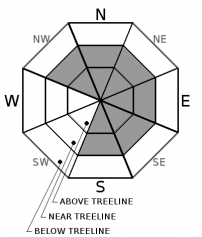
-
Likelihood ?CertainVery LikelyLikelyPossible
 Unlikely
 -
Size ?HistoricVery LargeLargeSmall

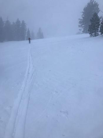
The Old Ski Bowl is reporting 6 inches of new snow. Consistent west winds have been moderate maxing out at 28 mi/hr. This trend will to continue today. These directions and speeds tend to be very productive in producing wind slabs. Wind can deposit snow 10 times faster than snow falling from the sky and slabs can be up to 3 times thicker than the amount of snow fallen. Look for wind slabs primarily on easterly aspects but variable mountain winds and cross loading may produce wind slabs in unexpected locations. Cold temperatures will prevent a good bond with underlying snow surfaces and could allow reactive slabs to linger for several days. Wind slabs are usually found near and above treeline, but keep an eye out for them below treeline in isolated, wind affected areas.
If you encounter shooting cracks, blocking, whumphing, scoured areas, or wind drifts, wind slabs might be nearby. Be extra careful in entering terrain greater than 35 degrees.
Avalanche Problem 2: Storm Slab
-
Character ?

-
Aspect/Elevation ?
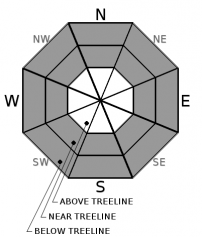
-
Likelihood ?CertainVery LikelyLikelyPossible
Unlikely
-
Size ?HistoricVery LargeLargeSmall
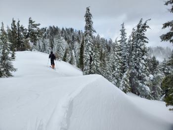
Small storm slabs could be encountered today on very steep slopes. The chutes on the west facing side of Gray Butte are a classic area to trigger a storm slab. Yesterday's snowfall was accompanied by increasing temperatures and winds which may lead to denser, more cohesive snow over less cohesive snow. Storm slabs fail within the new snow or at the new / old snow interface. Look for them in wind sheltered areas near and below treeline.
Forecast Discussion
Our forecast area covers a lot of different zones. What is happening on Mount Shasta might be very different than what is going on at Ash Creek Butte, Castle Lake, or the Eddies. These latter zones are affected differently by winds, temperatures, and a more shallow snowpack. A weak layer continues to linger in areas west of I-5 on northerly aspects. With a significant storm on deck for Wednesday night, this layer should be evaluated carefully in the coming days before entering avalanche terrain from above or below.
On Mount Shasta, be prepared for very cold conditions above treeline. Climbing into inclement weather is not recommended, but if you dare, expect firm conditions where winds have scoured snow surfaces. Bring an ice axe and crampons.
Recent Observations
Various weather stations are reporting 3-6 inches of snow received in the last 24 hours. Temperatures have ranged from 15 to 20 degrees on Mount Shasta. West winds have been mostly moderate, maxing out at 28 mi/hr.
With only 1-2 inches of new snow, not much had changed yesterday afternoon on Mount Shasta. Near and above treeline, moraines, ridgetops, and west facing aspects were mostly scoured. Small, inconsequential wind slabs were encountered in low angle terrain, but not in start zones. The northeast side of Coyote Butte at the Mount Shasta Ski Park has seen near 90 cm of wind loading, though ECT tests yielded no failures or propagation (ECTX).
The Eddies paint a different picture. A weak layer of granular snow persists under about 8-10 inches of harder snow. Wind drifts up to 60 cm were encountered. Ski cuts on test slopes indicated an unstable snow configuration. It was disconcerting enough to keep skiers on lower angle terrain.
Weather and Current Conditions
Weather Summary
A winter weather advisory remains in effect until 10 a.m.
Snow accumulation of 1-2 inches is expected today and a trace tonight. Snow levels could drop to as low as 1,500 ft with temperatures reaching the single digits at higher elevations. Expect moderate to strong west winds above treeline. They're gonna chill you to the bone.
A surface low developing off the northwest coast will bring a southerly flow of wet weather tomorrow with the bulk of the associated snow coming tomorrow night. All told, this system looks to bring us 10-18 inches above 2,000 ft by Thursday night.
24 Hour Weather Station Data @ 4:00 AM
| Weather Station | Temp (°F) | Wind (mi/hr) | Snow (in) | Comments | ||||||||
|---|---|---|---|---|---|---|---|---|---|---|---|---|
| Cur | Min | Max | Avg | Avg | Max Gust | Dir | Depth | New | Water Equivalent | Settlement | ||
| Mt. Shasta City (3540 ft) | 26 | 22 | 34 | 29 | 1 | N | ||||||
| Sand Flat (6750 ft) | 19 | 17 | 25 | 22 | 41 | 3 | 0 | 2 | ||||
| Ski Bowl (7600 ft) | 16.5 | 14.5 | 20.5 | 18 | 52 | 6.1 | 0.12 | 0.8 | ||||
| Gray Butte (8000 ft) | 13.5 | 13.5 | 19.5 | 17 | 21 | 37 | W | |||||
| Castle Lake (5870 ft) | down | |||||||||||
| Mount Eddy (6509 ft) | 19.5 | 16 | 25.5 | 22.5 | 2 | 11 | SSE | 39.9 | 5 | 5 | ||
| Ash Creek Bowl (7250 ft) | down | |||||||||||
| Ash Creek Ridge (7895 ft) | down |
Two Day Mountain Weather Forecast
Produced in partnership with the Medford NWS
| For 7000 ft to 9000 ft | |||
|---|---|---|---|
|
Tuesday (4 a.m. to 10 p.m.) |
Tuesday Night (10 p.m. to 4 a.m.) |
Wednesday (4 a.m. to 10 p.m.) |
|
| Weather | Snow showers likely. Mostly cloudy. Chance of precipitation is 70%. | A 30 percent chance of snow showers. Mostly cloudy. | A chance of snow showers before 10 a.m., then snow likely, mainly after 4 p.m. The snow could be heavy at times. Increasing winds. Gusty. Chance of precipitation is 60%. |
| Temperature (°F) | 20 | 19 | 22 |
| Wind (mi/hr) | West 10-15 | Southwest 5-10 | South 10-15 |
| Precipitation SWE / Snowfall (in) | 0.10 / 1-2 | 0.01 / 0-0.25 | 0.26 / 2-4 |
| For 9000 ft to 11000 ft | |||
| Tuesday | Tuesday Night | Wednesday | |
| Weather | Snow showers likely. Cloudy and cold. Windy and gusty. Low wind chills. Chance of precipitation is 70%. | A 30 percent chance of snow showers. Mostly cloudy. Windy and gusty. Low wind chills. | A chance of snow showers before 10 a.m., then snow likely, mainly after 4 p.m. The snow could be heavy at times. Windy and gusty. Low wind chills. Chance of precipitation is 60%. |
| Temperature (°F) | 7 | 7 | 13 |
| Wind (mi/hr) | West 25-30 | West 15-20 | Southwest 30-35 |
| Precipitation SWE / Snowfall (in) | 0.10 / 1-2 | 0.01 / 0-0.25 | 0.26 / 2-4 |
Season Precipitation for Mount Shasta City
| Period | Measured (in) | Normal (in) | Percent of Normal (%) |
|---|---|---|---|
| From Oct 1, 2025 (the wet season) | 9.47 | 18.34 | 52 |
| Month to Date (since Jul 1, 2026) | 0.54 | 3.13 | 17 |
| Year to Date (since Jan 1, 2026) | 0.54 | 3.13 | 17 |

