

You are here
Avalanche Forecast for 2020-01-15 07:00
- EXPIRED ON January 16, 2020 @ 7:00 amPublished on January 15, 2020 @ 7:00 am
- Issued by Aaron Beverly - Mount Shasta Avalanche Center
Bottom Line
Avalanche danger will be MODERATE today due to the continued growth of wind slabs from new and existing snow. A significant storm will begin impacting the area in earnest after 10 p.m. tonight, bringing over 12 inches of snow by early Thursday. With the new snow, concern for wind slabs, storms slabs, and persistent slabs will rise. Expect CONSIDERABLE avalanche danger by tomorrow morning.


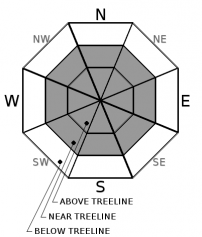
Avalanche Problem 1: Wind Slab
-
Character ?

-
Aspect/Elevation ?
-
Likelihood ?CertainVery LikelyLikelyPossible
 Unlikely
 -
Size ?HistoricVery LargeLargeSmall

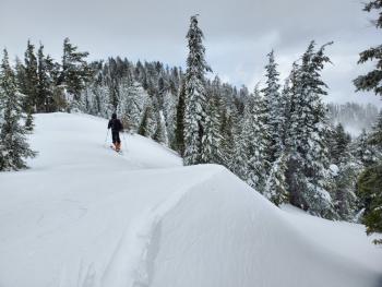
Steady, light winds yesterday were productive in building cornices and loading the top portion of slopes. This process will continue today with more snow and moderate to gale force winds expected. Though predominantly from the south, winds are going to be crazy and unpredictable out there. Look for winds slabs on all aspects. They are usually found near and above treeline on leeward slopes, but keep an eye out for them below treeline in isolated, wind affected areas.
Wind slab avalanches will be possible today but will become much more likely with increased destructive power by tomorrow morning.
If you encounter shooting cracks, blocking, whumphing, scoured areas, or wind drifts, wind slabs might be nearby. Be extra careful when entering terrain greater than 35 degrees.
Forecast Discussion
Because our region is unlikely to be affected significantly by the incoming winter storm until late tonight, we have chosen to keep avalanche danger at MODERATE for today with the primary concern for wind slab avalanches. However, between 10 p.m. and 4 a.m. Thursday, over a foot of snow could fall. We expect avalanche danger to rise to CONSIDERABLE by tomorrow morning. This means:
- Wind slab avalanches will become likely with increased destructive power.
- Storm slabs will be possible and big enough to bury or kill a person near or below treeline on slopes approaching 40 degrees.
- With additional weight from new snow and wind loading, persistent slab avalanches will be possible near and below treeline, particularly in lower elevation regions such as the Eddies, west of I-5, and Ash Creek Butte, east of Mount Shasta. These are the release of a cohesive layer of soft to hard snow in the middle to upper snowpack, when the bond to an underlying persistent weak layer breaks.
Over the next few days, keep in mind the 5 red flags of avalanche danger:
- Recent avalanches
- Cracking, blocking, or whumphing *
- Significant snowfall *
- Strong winds *
- Temperature rise
* - These have been seen or are expected in the next 24 hours
Recent Observations
In the last 24 hours on Mount Shasta, about an inch of new snow has been received. Temperatures have ranged from 11 to 15°F. West / northwest winds have averaged 15 mi/hr, maxing out at 24.
Near Gumboot Lake, west of I-5, about 8 inches of new snow fell during the last storm and about 17 inches of low density snow dominates the surface. Total depth is about 55 inches. Instabilities in the snowpack were seen. Column and block tests yielded notable failures (CT2x2 SP ↓ 35 cm, ECTP12 SP ↓ 35 cm). Failures occurred below a razor thin sun crust atop unbonded granular snow. The underlying snowpack is a mix of breakable crusts and sugary snow. These lingering weak layers could pose a problem with additional loading. On ridgelines, steady, light southwest winds were forming cornices and loading the top portion of slopes. Cornices and winds slabs were still small and stubborn to trigger, though blocking and cracking were seen.
Similar conditions were seen at Ash Creek Butte.
Weather and Current Conditions
Weather Summary
The storm we've all been waiting for is on deck. A winter storm warning will be in effect from 4 p.m. this afternoon to 4 p.m. Thursday.
A surface low has developed off the northwest coast that is bringing a wet southerly upslope flow to Mount Shasta, a pattern notorious for producing copious amounts of snow and gale force winds.
Before 10 p.m., expect 2-3 inches above 3,000 ft. Then the faucet turns on. From 10 p.m. tonight to 4 a.m. tomorrow, plan on 8-15 inches. Tomorrow, another 10-18 inches could fall.
All told we may get 20-36 inches out of this one. In the next 24 hours, expect 10-18 inches of snow, moderate to gale force southerly winds, and low snow levels (2,000 - 3,000 ft). Don't be caught on I-5 after 4 p.m. today.
24 Hour Weather Station Data @ 6:00 AM
| Weather Station | Temp (°F) | Wind (mi/hr) | Snow (in) | Comments | ||||||||
|---|---|---|---|---|---|---|---|---|---|---|---|---|
| Cur | Min | Max | Avg | Avg | Max Gust | Dir | Depth | New | Water Equivalent | Settlement | ||
| Mt. Shasta City (3540 ft) | 30 | 23 | 35.5 | 30.5 | 0 | N | ||||||
| Sand Flat (6750 ft) | 18 | 14 | 25 | 20 | 42 | 1 | 0 | 0 | ||||
| Ski Bowl (7600 ft) | 13 | 11 | 19 | 14.5 | 51.4 | 1.5 | 0.01 | 0 | ||||
| Gray Butte (8000 ft) | 12.5 | 11 | 18.5 | 14.5 | 14 | 37 | WNW | |||||
| Castle Lake (5870 ft) | down | |||||||||||
| Mount Eddy (6509 ft) | 15 | 12 | 24 | 18 | 1 | 12 | SSE | 43.4 | 1 | 0 | ||
| Ash Creek Bowl (7250 ft) | down | |||||||||||
| Ash Creek Ridge (7895 ft) | down |
Two Day Mountain Weather Forecast
Produced in partnership with the Medford NWS
| For 7000 ft to 9000 ft | |||
|---|---|---|---|
|
Wednesday (4 a.m. to 10 p.m.) |
Wednesday Night (10 p.m. to 4 a.m.) |
Thursday (4 a.m. to 10 p.m.) |
|
| Weather | Snow likely, mainly after 4 p.m. Increasing winds. Windy and gusty. Low wind chills. Chance of precipitation is 60%. | Snow. The snow could be heavy at times. Very windy and gusty. Low wind chills. Chance of precipitation is 100%. | Snow showers. The snow could be heavy at times. Windy and gusty. Low wind chills. Chance of precipitation is 100%. |
| Temperature (°F) | 19 | 24 | 23 |
| Wind (mi/hr) | South 15-20 | South 25-30 | South 10-15 |
| Precipitation SWE / Snowfall (in) | 0.17 / 2-3 | 0.75 / 8-12 | 0.91 / 10-14 |
| For 9000 ft to 11000 ft | |||
| Wednesday | Wednesday Night | Thursday | |
| Weather | Snow likely, mainly after 4 p.m. Mostly cloudy. Windy and gusty. Low wind chills. Chance of precipitation is 60%. | Snow. The snow could be heavy at times. Very windy and gusty. Low wind chills. Chance of precipitation is 100%. | Snow showers. The snow could be heavy at times. Windy and gusty. Low wind chills. Chance of precipitation is 100%. |
| Temperature (°F) | 17 | 12 | 13 |
| Wind (mi/hr) | Southwest 35-45 | South 55-65 | Southwest 35-45 |
| Precipitation SWE / Snowfall (in) | 0.17 / 2-3 | 0.75 / 10-15 | 0.91 / 13-18 |
Season Precipitation for Mount Shasta City
| Period | Measured (in) | Normal (in) | Percent of Normal (%) |
|---|---|---|---|
| From Oct 1, 2025 (the wet season) | 9.47 | 18.34 | 52 |
| Month to Date (since Jul 1, 2026) | 0.54 | 3.13 | 17 |
| Year to Date (since Jan 1, 2026) | 0.54 | 3.13 | 17 |

