

You are here
Avalanche Forecast for 2020-01-26 06:50
- EXPIRED ON January 27, 2020 @ 6:50 amPublished on January 26, 2020 @ 6:50 am
- Issued by Ryan Sorenson - Mount Shasta Avalanche Center
Bottom Line
The recent warm temperatures followed by colder conditions today will allow the snowpack to continue to settle and stabilize. Large avalanches have become increasingly unlikely. Generally, stable conditions and LOW avalanche danger remain. Isolated steep or extreme east-facing terrain may host small lingering wind slabs in the alpine on Mount Shasta.


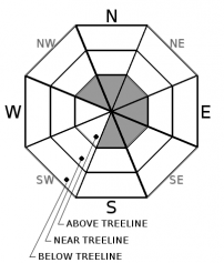
Avalanche Problem 1: Wind Slab
-
Character ?

-
Aspect/Elevation ?
-
Likelihood ?CertainVery LikelyLikelyPossible
 Unlikely
 -
Size ?HistoricVery LargeLargeSmall

As the snowpack continues to settle and stabilize, large wind slab avalanches will become increasingly unlikely. Snow transport by wind is presumed to have been minimal due to the heavy, wet nature of the recent storm. Colder temperatures today will help lock up the previously moist snow. Natural avalanches are unlikely.
Continue to evaluate the snow and terrain as you venture out today. Use caution in alpine areas above treeline where more snow has fallen. Isolated steep or extreme east-facing terrain may host lingering wind slabs on Mount Shasta. If venturing into couloirs, cliff areas, or other complex areas where snowpack variability is usually greater, expect a higher likelihood of finding isolated areas of unstable snow. Large human triggered wind slab avalanches are increasingly unlikely, however, not impossible today. Signs that wind slabs might be nearby include shooting cracks, blocking, whumphing, scoured areas, or wind drifts.
Forecast Discussion
Don't let the danger rating lull you into complacency. Always carry avalanche rescue equipment: transceiver, probe, and shovel. It is essential to be familiar with your gear. Always check that your gear is in proper functioning order BEFORE you leave the trailhead. Below is a video produced by the American Mountain Guides Association showing how to perform an avalanche beacon function check.
Recent Observations
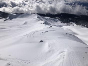
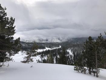
Wet and rainy conditions were observed at Bunny Flat on Mount Shasta yesterday. Snowmobilers in Old Ski Bowl reported spitting rain and very low visibility up to 8,000 feet. No signs of instability were observed.
In the last 24 hours on Mount Shasta:
- 1.15 inches of water was recorded at 7,600 feet.
- Temperatures have ranged from 29 to 32 degrees F at 8,000 feet.
- Steady westerly winds have averaged 13 mi/hr, with gusts up to 31 mi/hr at 8,000 feet.
- The height of snow (HS) at 7,600 feet is 72 inches.
Weather and Current Conditions
Weather Summary
Rain and snow showers will begin to diminish this morning. Snow levels will drop to 5,600 feet as colder, mostly cloudy, and drier conditions set in this afternoon. A second storm will arrive early tomorrow morning, bringing the possibility of light snow showers through Tuesday morning. Only a small amount of available water (0.20 inches of SWE) will reach the area, but snow levels should remain near 5,200 feet. Steady winds out of the south and west are forecast for the next few days.
24 Hour Weather Station Data @ 5:00 AM
| Weather Station | Temp (°F) | Wind (mi/hr) | Snow (in) | Comments | ||||||||
|---|---|---|---|---|---|---|---|---|---|---|---|---|
| Cur | Min | Max | Avg | Avg | Max Gust | Dir | Depth | New | Water Equivalent | Settlement | ||
| Mt. Shasta City (3540 ft) | 43 | 41 | 48 | 43.5 | 1 | N | ||||||
| Sand Flat (6750 ft) | 33 | 32 | 36 | 34 | 55 | 0 | 1 | 0 | ||||
| Ski Bowl (7600 ft) | 30 | 30 | 33.5 | 32 | 72.2 | 0 | 1.17 | 0 | ||||
| Gray Butte (8000 ft) | 29 | 29 | 32 | 31 | 13 | 31 | W | |||||
| Castle Lake (5870 ft) | down | |||||||||||
| Mount Eddy (6509 ft) | 32 | 32 | 39 | 35 | 1 | 10 | S | 46.3 | 1.5 | 0 | ||
| Ash Creek Bowl (7250 ft) | down | |||||||||||
| Ash Creek Ridge (7895 ft) | down |
Two Day Mountain Weather Forecast
Produced in partnership with the Medford NWS
| For 7000 ft to 9000 ft | |||
|---|---|---|---|
|
Sunday (4 a.m. to 10 p.m.) |
Sunday Night (10 p.m. to 4 a.m.) |
Monday (4 a.m. to 10 p.m.) |
|
| Weather | Mostly cloudy. Snow likely in the morning, then chance of snow showers. Chance of precipitation is 90%. Snow levels near 5,600 feet. | Mostly cloudy. Light snow showers are possible. Chance of snow is 30%. Snow levels near 4,700. | Mostly cloudy. Light snow showers are possible. Chance of snow is 50%. Snow levels near 4,900. |
| Temperature (°F) | 39 | 31 | 39 |
| Wind (mi/hr) | West 10-15 | Southwest 5-10 | Southwest 10-15 |
| Precipitation SWE / Snowfall (in) | 0.03 / 0-1 | 0.00 / 0 | 0.01 / 0-0.50 |
| For 9000 ft to 11000 ft | |||
| Sunday | Sunday Night | Monday | |
| Weather | Mostly cloudy. Snow showers possible before 10 AM. Windy. Wind chill values as low as -4 F. | Mostly cloudy. Windy. Wind chill values as low as -6 F. | Mostly cloudy. A 50 percent chance of snow showers. Windy. Wind chill values as low as -5 F. |
| Temperature (°F) | 21 | 18 | 24 |
| Wind (mi/hr) | West 25-30 | West 30-35 | West 35-40 |
| Precipitation SWE / Snowfall (in) | 0.03 / 0-1 | 0.00 / 0 | 0.01 / 0-0.50 |
Season Precipitation for Mount Shasta City
| Period | Measured (in) | Normal (in) | Percent of Normal (%) |
|---|---|---|---|
| From Oct 1, 2025 (the wet season) | 12.56 | 21.00 | 60 |
| Month to Date (since Jun 1, 2026) | 3.63 | 5.79 | 63 |
| Year to Date (since Jan 1, 2026) | 3.63 | 5.79 | 63 |

