

You are here
Avalanche Forecast for 2020-01-27 07:00
- EXPIRED ON January 28, 2020 @ 7:00 amPublished on January 27, 2020 @ 7:00 am
- Issued by Ryan Sorenson - Mount Shasta Avalanche Center
Bottom Line
Stable conditions and LOW avalanche danger exists for all elevations today. Less than one inch of new snow and strong west wind is forecast. Isolated steep or extreme east-facing terrain may host small wind slabs in the alpine on Mount Shasta.


Avalanche Problem 1: Wind Slab
-
Character ?

-
Aspect/Elevation ?
-
Likelihood ?CertainVery LikelyLikelyPossible
 Unlikely
 -
Size ?HistoricVery LargeLargeSmall

Even though cold and blustery conditions were blowing snow around yesterday, little recent wind slab formation was observed. Stronger wind out of the west is forecast today. For the most part, the snow available to drift and deposit as unstable wind slabs is very limited, especially where rain has created a crust below approximately 8,500 feet. There is less than one inch of new snow predicted today. Large human triggered wind slab avalanches are unlikely. However, if venturing into steep east facing couloirs, cliff areas, or other complex areas where snowpack variability is usually greater, you may find isolated areas of unstable snow. Pay attention to warning signs like shooting cracks, blocking, whumphing, scoured areas, or wind drifts as wind slabs might be nearby.
Forecast Discussion
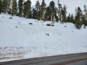
A small natural wet-slab avalanche occurred on the road cut below Bunny Flat sometime between 10:30 and 1:30 PM. Though these slides tend to happen every year because of the unsupported nature of the road cuts just below the Bunny Flat parking lot, they are still good events to learn from. A combination of rain on snow and solar radiation saturated most of the snowpack down to the ground. A shallow snow pack, with steep temperature gradients, and multiple crusts exists below and near treeline. In some areas weak, sugary layers still persist between thin crusts below the upper snowpack. This is something to keep in eye on for future snow / rain / warming events.
Don't let the danger rating lull you into complacency. Always carry avalanche rescue equipment: transceiver, probe, and shovel. It is essential to be familiar with your gear. Always check that your gear is in proper functioning order BEFORE you leave the trailhead. Below is a video produced by the American Mountain Guides Association showing how to perform an avalanche beacon function check.
Recent Observations
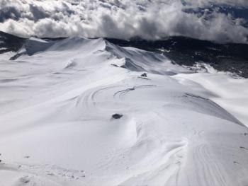
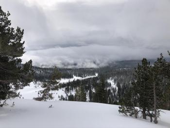
On a tour into Old Ski Bowl yesterday we observed variable snow conditions. Below treeline terrain hosted a breakable rain crust that gave way to wet snow beneath. This crust had remelted in the afternoon. Approximately an inch of new snow was observed above a breakable crust near treeline. Mostly smooth but variable wind packed, chalky snow and sastrugi snow surfaces remain at higher altitudes. Wind slabs 2 to 4 inches deep were observed on east-facing terrain near 10,000 feet though very little blocking or cracking was detected. Column and block test yielded no notable results. Strong winds out of the west were actively blowing snow, however, little accumulation and slab formation was happening.
In the last 24 hours on Mount Shasta:
- Temperatures have ranged from 21 to 30 degrees F at 8,000 feet.
- Steady westerly winds have averaged 15 mi/hr, with gusts up to 31 mi/hr at 8,000 feet.
- The height of snow (HS) at 7,600 feet measures 70 inches.
Weather and Current Conditions
Weather Summary
A series of weak storms have reached the forecast area bringing the possibility of light snow showers today. These storms have a small amount of total available water (0.52 inches of SWE), and the snow showers will be spread out until Wednesday. Expect continued light snow showers with brief periods of clearer conditions. Up to an inch of new snow will fall today. Snow levels will remain around 5,100 feet throughout the storm, with only a slight increase to 5,500 feet possible tonight. Steady strong winds out of the south and west will continue for the next few days with the strongest wind forecast today. Clear skies will return to the area Thursday.
24 Hour Weather Station Data @ 5:00 AM
| Weather Station | Temp (°F) | Wind (mi/hr) | Snow (in) | Comments | ||||||||
|---|---|---|---|---|---|---|---|---|---|---|---|---|
| Cur | Min | Max | Avg | Avg | Max Gust | Dir | Depth | New | Water Equivalent | Settlement | ||
| Mt. Shasta City (3540 ft) | 36 | 35 | 51 | 42.5 | 0 | N | ||||||
| Sand Flat (6750 ft) | 29 | 29 | 34 | 31 | 52 | 0 | 0 | 0 | ||||
| Ski Bowl (7600 ft) | 25.5 | 24 | 32 | 27.5 | 70.3 | 0 | 0.03 | 2 | ||||
| Gray Butte (8000 ft) | 25 | 21.5 | 30 | 26 | 15 | 31 | WNW | |||||
| Castle Lake (5870 ft) | down | |||||||||||
| Mount Eddy (6509 ft) | 31 | 27.5 | 35 | 31 | 1 | 7 | SSE | 44.8 | 0 | 2 | ||
| Ash Creek Bowl (7250 ft) | down | |||||||||||
| Ash Creek Ridge (7895 ft) | down |
Two Day Mountain Weather Forecast
Produced in partnership with the Medford NWS
| For 7000 ft to 9000 ft | |||
|---|---|---|---|
|
Monday (4 a.m. to 10 p.m.) |
Monday Night (10 p.m. to 4 a.m.) |
Tuesday (4 a.m. to 10 p.m.) |
|
| Weather | Breezy. Mostly cloudy. Light snow showers, mainly before 10 AM and after 4 PM. Chance of snow is 80%. Snow levels near 5,100 feet. | Breezy. Mostly cloudy. Snow showers likely, mainly after midnight. Chance of snow is 80%. Snow levels near 5,500 feet. | Breezy. Snow showers in the morning, then snow showers likely in the afternoon. Chance of snow is 90%. Snow levels near 5,200 feet. |
| Temperature (°F) | 36 | 31 | 36 |
| Wind (mi/hr) | South 15-20 | South 10-15 | Southwest 15-20 |
| Precipitation SWE / Snowfall (in) | 0.16 / 0-1 | 0.14 / 0-1 | 0.22 / 1-2 |
| For 9000 ft to 11000 ft | |||
| Monday | Monday Night | Tuesday | |
| Weather | Very windy. Mostly cloudy. Light snow showers, mainly before 10 AM and after 4 PM. Wind chill values as low as -8 F. | Windy. Mostly cloudy. Snow showers likely, mainly after midnight. Chance of snow is 80%. Wind chill values as low as -10 F | Very windy. Snow showers in the morning, then snow showers likely in the afternoon. Chance of snow is 90%. Snow levels near 5,200 feet. Wind chill values as low as -15 |
| Temperature (°F) | 21 | 18 | 24 |
| Wind (mi/hr) | West 40-45 | West 30-35 | West 35-40 |
| Precipitation SWE / Snowfall (in) | 0.16 / 0-1 | 0.14 / 0-1 | 0.22 / 1-3 |
Season Precipitation for Mount Shasta City
| Period | Measured (in) | Normal (in) | Percent of Normal (%) |
|---|---|---|---|
| From Oct 1, 2025 (the wet season) | 12.62 | 21.22 | 59 |
| Month to Date (since Jun 1, 2026) | 3.69 | 6.01 | 61 |
| Year to Date (since Jan 1, 2026) | 3.69 | 6.01 | 61 |

