

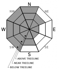
You are here
Avalanche Forecast for 2020-03-16 07:00
- EXPIRED ON March 17, 2020 @ 7:00 amPublished on March 16, 2020 @ 7:00 am
- Issued by Ryan Sorenson - Mount Shasta Avalanche Center
Bottom Line
Light snow showers and productive easterly wind will continue today. Wind drifted snow that has formed into slabs remains the main avalanche problem. Human triggered avalanches are possible on steep near and above treeline terrain. MODERATE avalanche danger exists. Continue to evaluate the snow and choose terrain wisely as the snowpack continues to settle.


Avalanche Problem 1: Wind Slab
-
Character ?

-
Aspect/Elevation ?
-
Likelihood ?CertainVery LikelyLikelyPossible
 Unlikely
 -
Size ?HistoricVery LargeLargeSmall

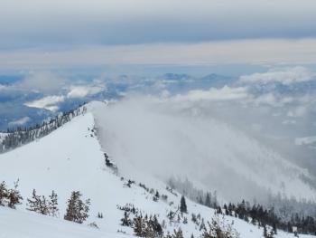
Though little wind slab formation has been observed recently, increasing temperatures and continued wind will allow for further slab formation today. The fresh snow is light, unconsolidated and available for wind transport. Productive easterly winds are forecast. Loaded leeward W-NW-N are most suspect; however, wind direction can change as terrain features create eddies and varying wind behavior. Wind slab avalanches are possible near and above treeline where wind drifted snow has accumulated. Identify wind slabs by looking for new cornice development, and pillows of wind drifted snow. Wind slabs are often smooth and round and sometimes sound hollow.
Forecast Discussion
A level of uncertainty remains about the temperature today. If colder temperatures persist, small fan-shaped loose dry avalanches may be possible in terrain steeper than 40 degrees. If the sun comes out, temperatures may rise rapidly. Rising temperatures cause concern for loose wet avalanches. Rollerballs are an indication that instability associated with loose wet avalanches is forming. Choose terrain wisely and consider how consequences from otherwise small avalanches can be exacerbated by terrain traps, trees, rocks, or cliffs.
Be sure to make conservative decisions and watch for the five red flags for avalanche danger:
- recent avalanches
- cracking, blocking and whumping
- significant snowfall in 24 hours
- strong winds
- temperature rise
Recent Observations
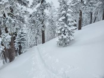
In the last 48 hours, the Old Ski Bowl weather station has recorded 15.5 inches of fresh snow (0.75 SWE). The majority of the new snow fell Saturday night (03.14.2020) between the hours of 1600 and 2300 and yesterday (03.15.2020) between the hours of 0400 and 1900.
On a tour up, Gray Butte approximately 13 inches of light low-density snow sits above a thick crusty and well-consolidated snowpack below. Surface penetrability by skis was 8 to 10 inches deep. Snow surfaces were mostly smooth, with little wind effects noted. Some drifts up to two feet deep were encountered along the ridgeline near the summit of Gray Butte. Sluffing and minor cracking occurred on west-facing test slopes that were steeper than 40 degrees.
Variable winds averaged 11 m/hr over the last 24 hours at our Gray Butte weather station. Temperatures have averaged 14 F, maxing out at 21 F, with a minimum of 10 F at 8,000 feet.

Weather and Current Conditions
Weather Summary
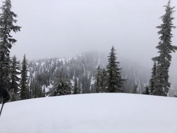
Expect mostly cloudy skies and some lingering snow showers today. A large storm located to the southeast is allowing waves of precipitation to drift through the area. Short periods of sunny skies will mix with large building clouds and varying snow showers. Chances of snow showers will gradually decrease this afternoon. Optimistically speaking, we could see up to 2 inches of snow accumulation with snow levels near 2,500 feet. Light to moderate winds will be out of the east.
Clearer skies this evening will allow for a brief rise in snow levels tonight. A more significant wave of showery snow will push into the area sometime after midnight. A little more than a quarter-inch of precipitable water will impact the region. This will fall as 3 to 5 inches of snow with snow levels dropping back down near Mount Shasta City level tomorrow.
24 Hour Weather Station Data @ 6:00 AM
| Weather Station | Temp (°F) | Wind (mi/hr) | Snow (in) | Comments | ||||||||
|---|---|---|---|---|---|---|---|---|---|---|---|---|
| Cur | Min | Max | Avg | Avg | Max Gust | Dir | Depth | New | Water Equivalent | Settlement | ||
| Mt. Shasta City (3540 ft) | 25 | 22 | 35 | 29 | 1 | N | ||||||
| Sand Flat (6750 ft) | 19 | 14 | 25 | 19 | 44 | 0 | 0 | 0 | ||||
| Ski Bowl (7600 ft) | 18 | 10.5 | 19 | 15 | 73.8 | 9.3 | 0 | 0 | ||||
| Gray Butte (8000 ft) | 15.5 | 10 | 21 | 14 | 12 | 31 | E | |||||
| Castle Lake (5870 ft) | 19.5 | 15.5 | 28.5 | 21 | 44 | 7.8 | 0 | |||||
| Mount Eddy (6509 ft) | 17 | 13 | 21 | 17 | 1 | 8 | S | 84.9 | 0 | 0 | ||
| Ash Creek Bowl (7250 ft) | down | |||||||||||
| Ash Creek Ridge (7895 ft) | down |
Two Day Mountain Weather Forecast
Produced in partnership with the Medford NWS
| For 7000 ft to 9000 ft | |||
|---|---|---|---|
|
Monday (4 a.m. to 10 p.m.) |
Monday Night (10 p.m. to 4 a.m.) |
Tuesday (4 a.m. to 10 p.m.) |
|
| Weather | Mostly cloudy. Chance of snow showers 40 percent. Snow levels near 2,500 feet | Snow showers likely mainly after midnight. Chance of snow showers 60 percent. Snow levels rising to 4,400 feet. | Snow showers. Chance of snow showers 90 percent. Snow levels near 2,500 feet |
| Temperature (°F) | 33 | 25 | 29 |
| Wind (mi/hr) | East 10-15 | Northeast 5-10 | Southwest 5-10 |
| Precipitation SWE / Snowfall (in) | 0.11 / 0-2 | 0.08 / 0-1 | 0.30 / 3-4 |
| For 9000 ft to 11000 ft | |||
| Monday | Monday Night | Tuesday | |
| Weather | Mostly cloudy. Snow showers possible. | Snow showers likely mainly after midnight. | Snow showers. |
| Temperature (°F) | 21 | 19 | 19 |
| Wind (mi/hr) | Southeast 25-30 | East 15-20 | North 15-20 |
| Precipitation SWE / Snowfall (in) | 0.11 / 0-2 | 0.08 / 0-1 | 0.30 / 3-5 |
Season Precipitation for Mount Shasta City
| Period | Measured (in) | Normal (in) | Percent of Normal (%) |
|---|---|---|---|
| From Oct 1, 2025 (the wet season) | 13.68 | 32.80 | 42 |
| Month to Date (since Jun 1, 2026) | 0.78 | 3.30 | 24 |
| Year to Date (since Jan 1, 2026) | 4.75 | 17.59 | 27 |

