

You are here
Avalanche Forecast for 2020-03-17 06:30
- EXPIRED ON March 18, 2020 @ 6:30 amPublished on March 17, 2020 @ 6:30 am
- Issued by Aaron Beverly - Mount Shasta Avalanche Center
Bottom Line
Avalanche danger is CONSIDERABLE. Up to 10 inches of new snow combined with moderate winds will make a human-triggered, wind slab avalanches likely near and above treeline. Storm slabs may be possible below treeline. Evaluate the snowpack, weather, and terrain carefully today.


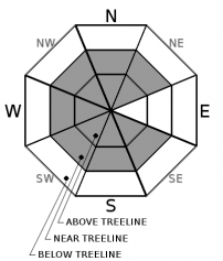
Avalanche Problem 1: Wind Slab
-
Character ?

-
Aspect/Elevation ?
-
Likelihood ?CertainVery LikelyLikelyPossible
 Unlikely
 -
Size ?HistoricVery LargeLargeSmall

Existing and new snow (up to 10 inches) will combine with moderate, north and northeast winds to increase the size of wind slabs.They could be several feet thick.
It will be important today to pay attention to the wind. Moderate wind (15-26 mi/hr) is often the most productive in creating slabs. Where is it blowing? Where is it drifting? Avoid leeward slopes above 35 degrees.
Shooting cracks, whumphing, and blocking indicate unstable snow. Look for these signs in safe terrain as you travel: edges of tree wells, small rollovers, and wind drifts. Shooting cracks were seen yesterday.
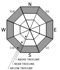
Avalanche Problem 2: Storm Slab
-
Character ?

-
Aspect/Elevation ?
-
Likelihood ?CertainVery LikelyLikelyPossible
Unlikely
-
Size ?HistoricVery LargeLargeSmall
Cold temperatures may keep this problem at bay, but don't rule it out if you are thinking of entering steep areas below treeline approaching 40 degrees.
A storm slab avalanche is the release of a soft, cohesive layer of new snow that breaks within the storm snow or on the old snow surface. You can reduce your risk from storm slabs by waiting a day or two after a storm before venturing into steep terrain. Storm slabs are most dangerous on slopes with terrain traps below.
Ski cuts above short, steep areas of no consequence are the best way to test for this problem.
Forecast Discussion
Today will be a good day to pay attention to the five red flags of avalanche danger:
- Recent avalanches
- New snow *
- Collapsing, cracking, or blocking *
- Blowing snow *
- Rapid temperature rise
* These have been seen or are expected today.
Recent Observations
On Mount Shasta, near treeline temperatures ranged from 16 to 31 degrees. Easterly winds were moderate to strong, ranging from 16 to 33 mi/hr. A couple more inches of snow fell bringing the grand total storm snow since Saturday to 19 inches. Rising temperatures settled the snow by about 3 inches.
Yesterday around 1:30 p.m. in the Old Ski Bowl, wind was loading southwest and west slopes. New wind loaded snow was up to 36 inches. Shooting cracks that propagated up to 15 ft were easily produced in these areas raising concern for wind slab avalanches. Similar conditions were seen in the Eddies.

Weather and Current Conditions
Weather Summary
Another round of winter weather impacts the area today. A winter storm warning is in effect until 2 a.m. tomorrow.
In the next 24 hours, expect 5-10 inches of snow. North and northeast winds will be moderate, 20-25 mi/hr. Snow levels will be near 3,000 ft.
24 Hour Weather Station Data @ 5:00 AM
| Weather Station | Temp (°F) | Wind (mi/hr) | Snow (in) | Comments | ||||||||
|---|---|---|---|---|---|---|---|---|---|---|---|---|
| Cur | Min | Max | Avg | Avg | Max Gust | Dir | Depth | New | Water Equivalent | Settlement | ||
| Mt. Shasta City (3540 ft) | 32 | 25 | 42 | 34 | 0 | N | ||||||
| Sand Flat (6750 ft) | 26 | 19 | 32 | 28 | 42 | 0.5 | 0.04 | 2 | ||||
| Ski Bowl (7600 ft) | 23.5 | 18 | 31 | 25.5 | 69.8 | 2 | 0.04 | 2.9 | ||||
| Gray Butte (8000 ft) | 24 | 15.5 | 29 | 23.5 | 24 | 49 | E | |||||
| Castle Lake (5870 ft) | 26 | 19.5 | 31.5 | 28 | 42.4 | 1 | 2 | |||||
| Mount Eddy (6509 ft) | 26.5 | 17.5 | 30.5 | 27 | 2 | 8 | SSW | 56.4 | 1 | 2 | ||
| Ash Creek Bowl (7250 ft) | down | |||||||||||
| Ash Creek Ridge (7895 ft) | down |
Two Day Mountain Weather Forecast
Produced in partnership with the Medford NWS
| For 7000 ft to 9000 ft | |||
|---|---|---|---|
|
Tuesday (4 a.m. to 10 p.m.) |
Tuesday Night (10 p.m. to 4 a.m.) |
Wednesday (4 a.m. to 10 p.m.) |
|
| Weather | Snow. Chance of precipitation is 100%. | Snow. Chance of precipitation is 90%. | A 20 percent chance of snow showers. Partly sunny. |
| Temperature (°F) | 24 | 22 | 29 |
| Wind (mi/hr) | Southwest 5-10 | Southwest 5-10 | Southwest 0-5 |
| Precipitation SWE / Snowfall (in) | 0.45 / 4-7 | 0.15 / 1-3 | 0.01 / 0-0.50 |
| For 9000 ft to 11000 ft | |||
| Tuesday | Tuesday Night | Wednesday | |
| Weather | Snow. Low wind chills. Chance of precipitation is 100%. | Snow. Windy. Low wind chills. Chance of precipitation is 90%. | A 20 percent chance of snow showers. Partly sunny. Blustery. Low wind chills. |
| Temperature (°F) | 19 | 14 | 15 |
| Wind (mi/hr) | Northeast 20-25 | North 20-25 | Northwest 10-15 |
| Precipitation SWE / Snowfall (in) | 0.45 / 4-7 | 0.15 / 1-3 | 0.01 / 0-0.50 |
Season Precipitation for Mount Shasta City
| Period | Measured (in) | Normal (in) | Percent of Normal (%) |
|---|---|---|---|
| From Oct 1, 2025 (the wet season) | 14.11 | 33.20 | 43 |
| Month to Date (since Jul 1, 2026) | 1.21 | 3.70 | 33 |
| Year to Date (since Jan 1, 2026) | 5.18 | 17.99 | 29 |

