

You are here
Avalanche Forecast for 2020-03-18 06:30
- EXPIRED ON March 19, 2020 @ 6:30 amPublished on March 18, 2020 @ 6:30 am
- Issued by Aaron Beverly - Mount Shasta Avalanche Center
Bottom Line
Avalanche danger is MODERATE due to some lingering concern for human-triggered wind slab avalanches. Evaluate steep, leeward slopes carefully near and above treeline. Clouds will give way to drier, clearer conditions after noon today.


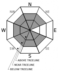
Avalanche Problem 1: Wind Slab
-
Character ?

-
Aspect/Elevation ?
-
Likelihood ?CertainVery LikelyLikelyPossible
 Unlikely
 -
Size ?HistoricVery LargeLargeSmall

Lower elevation zones yesterday indicated a stabilizing snow pack with a diminished concern for wind slabs. Observations at higher elevations were limited. Winds speeds ended up being light. Wind speeds today look to be mostly light. There is 7 inches of new, low density snow available for transport. You will be tempted to go get it. Remember, wind forecasts are not always spot on. If you are thinking of going high and getting into some avalanche terrain, evaluate snow and wind carefully. Leeward slopes above 35 degrees should still be approached mindfully.
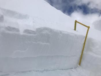
Shooting cracks, whumphing, and blocking indicate unstable snow. Look for these signs in safe terrain as you travel: stomp around edges of tree wells, above small rollovers, and in wind drifts.
Forecast Discussion
Keep in mind the five red flags of avalanche danger:
- Recent avalanches *
- New snow
- Collapsing, cracking, or blocking *
- Blowing snow *
- Rapid temperature rise
* Pay attention in particular to these today.
Recent Observations
The snow arrived later than expected, but about 7 inches fell near treeline on Mount Shasta. Temperatures ranged from 26 to 16 degrees, with the coldest temperatures maintaining during the bulk of the snowfall. Westerly winds were light peaking at 11 mi/hr, gusting up to 18. Grand total storm snow since Saturday is 23 inches.
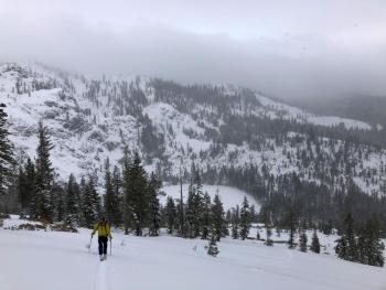
Tours of Cliff Lake and Parks Creek saw a shallow snowpack with about 12 inches of storm snow and below freezing temperatures. Lower elevations had a soft melt-freeze crust. Though winds were mostly calm, wind loading had occurred on west facing slopes. Ski cuts and hand tests indicated a settling and stabilizing snow pack. No obvious signs of instability were seen.

Weather and Current Conditions
Weather Summary
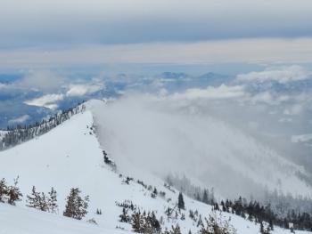
Scattered snow showers will linger today as we transition to drier, clearer conditions. No notable accumulation is expected. Extensive cloud cover will begin breaking up in the afternoon.
North to northeast winds look to be calm to light below treeline, but may be moderate at times above. Temperatures will remain below freezing. Snow levels will rise from 3,500 to 4,000 ft.
Precipitation returns Sunday.
24 Hour Weather Station Data @ 5:00 AM
| Weather Station | Temp (°F) | Wind (mi/hr) | Snow (in) | Comments | ||||||||
|---|---|---|---|---|---|---|---|---|---|---|---|---|
| Cur | Min | Max | Avg | Avg | Max Gust | Dir | Depth | New | Water Equivalent | Settlement | ||
| Mt. Shasta City (3540 ft) | 30 | 30 | 32 | 31 | 1 | N | ||||||
| Sand Flat (6750 ft) | 21 | 20 | 24 | 22 | 48 | 7 | 0 | 0 | ||||
| Ski Bowl (7600 ft) | 16.5 | 16 | 26.5 | 19.5 | 75 | 7 | 0.61 | 0 | ||||
| Gray Butte (8000 ft) | 18 | 15.5 | 25 | 18.5 | 8 | 31 | WNW | |||||
| Castle Lake (5870 ft) | 24.5 | 22.5 | 31.5 | 25 | 44.6 | 2.9 | 0 | |||||
| Mount Eddy (6509 ft) | 23 | 23 | 27.5 | 24.5 | 1 | 8 | SE | 57.1 | 0.5 | 0 | ||
| Ash Creek Bowl (7250 ft) | down | |||||||||||
| Ash Creek Ridge (7895 ft) | down |
Two Day Mountain Weather Forecast
Produced in partnership with the Medford NWS
| For 7000 ft to 9000 ft | |||
|---|---|---|---|
|
Wednesday (4 a.m. to 10 p.m.) |
Wednesday Night (10 p.m. to 4 a.m.) |
Thursday (4 a.m. to 10 p.m.) |
|
| Weather | Scattered snow showers. Partly sunny. Chance of precipitation is 50%. | Partly cloudy. | Mostly sunny. |
| Temperature (°F) | 29 | 20 | 36 |
| Wind (mi/hr) | West 0-5 | Northj 0-5 | East 0-5 |
| Precipitation SWE / Snowfall (in) | 0.01 / 0-0.25 | 0.00 / 0 | 0.00 / 0 |
| For 9000 ft to 11000 ft | |||
| Wednesday | Wednesday Night | Thursday | |
| Weather | Scattered snow showers. Partly sunny. Chance of precipitation is 50%. | Partly cloudy. | Mostly sunny. |
| Temperature (°F) | 16 | 15 | 19 |
| Wind (mi/hr) | North 10-15 | Northeast 10-15 | East 10-15 |
| Precipitation SWE / Snowfall (in) | 0.01 / 0-0.25 | 0.00 / 0 | 0.00 / 0 |
Season Precipitation for Mount Shasta City
| Period | Measured (in) | Normal (in) | Percent of Normal (%) |
|---|---|---|---|
| From Oct 1, 2025 (the wet season) | 14.64 | 33.38 | 44 |
| Month to Date (since Jun 1, 2026) | 1.74 | 3.88 | 45 |
| Year to Date (since Jan 1, 2026) | 5.71 | 18.17 | 31 |

