

You are here
Avalanche Forecast for 2020-03-19 05:51
- EXPIRED ON March 20, 2020 @ 5:51 amPublished on March 19, 2020 @ 5:51 am
- Issued by Nick Meyers - Shasta-Trinity National Forest
Bottom Line
A full day of sun and good visibility will entice many into all the fun skiing and riding zones. While the new snow has consolidated some, conditions are dynamic today which increases uncertainty. The interplay of new snow, wet snow, wind transporting snow and sunshine point to MODERATE avalanche danger.


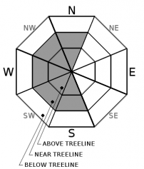
Avalanche Problem 1: Wind Slab
-
Character ?

-
Aspect/Elevation ?
-
Likelihood ?CertainVery LikelyLikelyPossible
 Unlikely
 -
Size ?HistoricVery LargeLargeSmall

Near and above treeline on westerly aspects, existing wind slabs 2-3 feet deep have shown moderate propensity for failure, 10 to 12 inches (30 cm) down from the snow surface. New snow has not been affected by wind; yesterday was dead calm. However, the new snow is low density and readily available for wind transport. The forecast today is calling out easterly wind, 10-15 mi/hr. Already on Gray Butte this morning, wind speeds are averaging 15-20 mi/hr with gusts to 25 mi/hr...most certainly enough to push a little snow around.
For today, watch for wind blowing snow and existing wind slabs to grow in size. Westerly aspects will be most suspect and I'd tread lightly on any wind loaded, leeward aspect where you see wind blowing snow. Traveling in sheltered terrain where wind slabs do not exist will provide softer, less wind affected snow as well as limit your exposure to potentially unstable wind slabs.
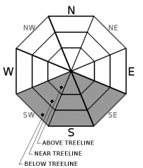
Avalanche Problem 2: Loose Wet
-
Character ?

-
Aspect/Elevation ?
-
Likelihood ?CertainVery LikelyLikelyPossible
Unlikely
-
Size ?HistoricVery LargeLargeSmall
Temperatures will climb to above freezing today and sunshine will hit a few slopes, rapidly wetting the new snow. Expect to see some pinwheels rolling downhill and loose, wet avalanches. These slides may not be large enough to bury you, but could gain size on large slopes. This is the time of year it only takes a short hit of sun to quickly turn the surface into an unconsolidated mess.
Forecast Discussion
Today is the first day of Spring! If you get out, please send us your observations no matter how brief. You can fill out a snowpack, avalanche or climbing route form, email us (shastaavalanche@gmail.com or Instagram (@shastaavalanche).
Recent Observations
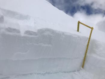
- Numerous snowpit tests targeting wind slabs above treeline, with moderate force, produced resistant planar, propagating results on Mount Shasta. ECTP12-14 down 12 inches (30cm) These tests were conducted on a west aspect, 8,800 feet.
- In some areas, a soft (1 finger) sun crust exists, sandwiched between the two storms we've received over the work week.
- In general, soft, low density snow (fist to 4 finger) is evenly distributed across the landscape...readily available for wind transport.
- While no obvious signs of instability were observed yesterday, the propagating ECT tests were a bit surprising.
- Sheltered slopes below treeline showed no signs of storm slab instability.

Weather and Current Conditions
Weather Summary
The cool, wet weather over the past week will continue to weaken over the next couple days. Expect sunny skies and warming temperatures. Below treeline, easterly winds will be light. Near and above treeline, expect moderate wind speeds. After Sunday, the weather will transition back to something winter-like!
24 Hour Weather Station Data @ 4:00 AM
| Weather Station | Temp (°F) | Wind (mi/hr) | Snow (in) | Comments | ||||||||
|---|---|---|---|---|---|---|---|---|---|---|---|---|
| Cur | Min | Max | Avg | Avg | Max Gust | Dir | Depth | New | Water Equivalent | Settlement | ||
| Mt. Shasta City (3540 ft) | 24 | 24 | 41 | 33 | 0 | N | ||||||
| Sand Flat (6750 ft) | 14 | 14 | 29 | 23 | 48 | 0 | 0 | 0 | ||||
| Ski Bowl (7600 ft) | 19.5 | 16 | 26.5 | 20.5 | 74 | 0 | 0.09 | 1 | ||||
| Gray Butte (8000 ft) | 20 | 18 | 24 | 20.5 | 8 | 31 | WNW | |||||
| Castle Lake (5870 ft) | 25.5 | 24 | 34.5 | 27 | 42.7 | 0 | 1.9 | |||||
| Mount Eddy (6509 ft) | 17.5 | 16.5 | 30.5 | 24 | 2 | 10 | SE | 56.7 | 0 | 0 | ||
| Ash Creek Bowl (7250 ft) | down | |||||||||||
| Ash Creek Ridge (7895 ft) | down |
Two Day Mountain Weather Forecast
Produced in partnership with the Medford NWS
| For 7000 ft to 9000 ft | |||
|---|---|---|---|
|
Thursday (4 a.m. to 10 p.m.) |
Thursday Night (10 p.m. to 4 a.m.) |
Friday (4 a.m. to 10 p.m.) |
|
| Weather | Sunny | Mostly clear | Sunny |
| Temperature (°F) | 35 | 20 | 37 |
| Wind (mi/hr) | East 0-5 | South/Southeast 0-5 | Southeast 0-5 |
| Precipitation SWE / Snowfall (in) | 0.00 / 0-0.25 | 0.00 / 0 | 0.00 / 0 |
| For 9000 ft to 11000 ft | |||
| Thursday | Thursday Night | Friday | |
| Weather | Sunny and windy | Mostly clear | Sunny |
| Temperature (°F) | 15 | 13 | 16 |
| Wind (mi/hr) | East/Northeast 10-15 | North/Northeast 10-15 | East/Southeast 10-15 |
| Precipitation SWE / Snowfall (in) | 0.00 / 0 | 0.00 / 0 | 0.00 / 0 |
Season Precipitation for Mount Shasta City
| Period | Measured (in) | Normal (in) | Percent of Normal (%) |
|---|---|---|---|
| From Oct 1, 2025 (the wet season) | 14.84 | 33.55 | 44 |
| Month to Date (since Jun 1, 2026) | 1.94 | 4.05 | 48 |
| Year to Date (since Jan 1, 2026) | 5.91 | 18.34 | 32 |

