

You are here
Avalanche Forecast for 2020-03-20 06:09
- EXPIRED ON March 21, 2020 @ 6:09 amPublished on March 20, 2020 @ 6:09 am
- Issued by Nick Meyers - Shasta-Trinity National Forest
Bottom Line
LOW avalanche danger and normal caution is advised today. Be mindful on the steeps, 40 degrees or greater, where small loose-point releases could be possible, either wet or dry, depending on your aspect.


Avalanche Problem 1: Normal Caution
-
Character ?

-
Aspect/Elevation ?
-
Likelihood ?CertainVery LikelyLikelyPossible
 Unlikely
 -
Size ?HistoricVery LargeLargeSmall

We're back to normal caution and most avalanche terrain will host LOW danger. Just like every other time you go out, wear your beacon and carry your shovel and probe. Watch for isolated wind slabs and/or loose point releases, wet or dry, in steep terrain.
Forecast Discussion
If you get out, please send us your observations no matter how brief. You can fill out a snowpack, avalanche or climbing route form, email us at shastaavalanche@gmail.com or Instagram (@shastaavalanche).
Recent Observations
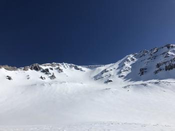
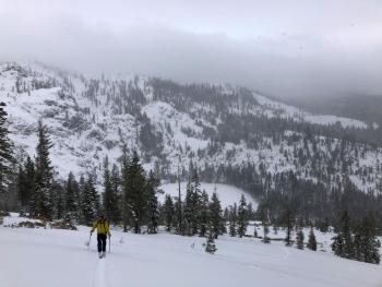
- Plenty of sliders and riders were out on slopes of all aspect and elevation yesterday. The snow held itself together pretty well. Temperatures creeped to just above freezing and with some air movement, allowed for the new snow to maintain a nice equilibrium with no major instabilities observed. Several inches of settlement occurred.
- Minor roller balls and a small point release observed off east/southeast aspects near/above treeline.
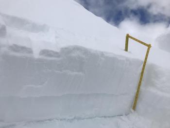
- Wind slabs showed a decrease in propensity toward failure, following up with column tests that produced planar, propagating results the day prior.
- A half-hearted period of moderate, easterly wind didn't affect snow surfaces to bad or transport much snow.
- A sun crust exists in some areas below treeline and perhaps near/above treeline on solar aspects.
- Soft snow still available out there in shaded areas, higher terrain and/or northerly aspects.
- Surface hoar developed below treeline in low lying areas.

Weather and Current Conditions
Weather Summary
A sunny day ahead. Temperatures will be several degrees warmer than yesterday. Wind will be generally light out of the east, with breezy conditions above treeline in open, higher terrain. Southerly flow increases Sunday as an upper low moves toward the coast.
24 Hour Weather Station Data @ 4:00 AM
| Weather Station | Temp (°F) | Wind (mi/hr) | Snow (in) | Comments | ||||||||
|---|---|---|---|---|---|---|---|---|---|---|---|---|
| Cur | Min | Max | Avg | Avg | Max Gust | Dir | Depth | New | Water Equivalent | Settlement | ||
| Mt. Shasta City (3540 ft) | 26 | 22 | 50 | 36 | 1 | N | ||||||
| Sand Flat (6750 ft) | 19 | 12 | 38 | 25 | 45 | 0 | 0 | 3 | ||||
| Ski Bowl (7600 ft) | 20.5 | 16.5 | 33.5 | 25 | 71.8 | 0 | 0 | 2.7 | ||||
| Gray Butte (8000 ft) | 23 | 19.5 | 28.5 | 24 | 12 | 25 | ESE | |||||
| Castle Lake (5870 ft) | 29.5 | 24 | 47.5 | 34 | 40.6 | 0 | 2.3 | |||||
| Mount Eddy (6509 ft) | 22 | 17 | 35 | 27 | 2 | 8 | SW | 56.1 | 0 | 0 | ||
| Ash Creek Bowl (7250 ft) | down | |||||||||||
| Ash Creek Ridge (7895 ft) | down |
Two Day Mountain Weather Forecast
Produced in partnership with the Medford NWS
| For 7000 ft to 9000 ft | |||
|---|---|---|---|
|
Friday (4 a.m. to 10 p.m.) |
Friday Night (10 p.m. to 4 a.m.) |
Saturday (4 a.m. to 10 p.m.) |
|
| Weather | Sunny | Mostly clear | Sunny |
| Temperature (°F) | 39 | 25 | 42 |
| Wind (mi/hr) | East 0-5 | Northeast 0-5 | Northeast 0-5 |
| Precipitation SWE / Snowfall (in) | 0.00 / 0 | 0.00 / 0 | 0.00 / 0 |
| For 9000 ft to 11000 ft | |||
| Friday | Friday Night | Saturday | |
| Weather | Sunny and breezy | Mostly clear | Sunny. Slight chance of snow after 2PM |
| Temperature (°F) | 17 | 15 | 18 |
| Wind (mi/hr) | East 10-15 | East 10-15 | East 5-10 |
| Precipitation SWE / Snowfall (in) | 0.00 / 0 | 0.00 / 0 | 0.00 / 0 |
Season Precipitation for Mount Shasta City
| Period | Measured (in) | Normal (in) | Percent of Normal (%) |
|---|---|---|---|
| From Oct 1, 2025 (the wet season) | 14.84 | 33.72 | 44 |
| Month to Date (since Jun 1, 2026) | 1.94 | 4.22 | 45 |
| Year to Date (since Jan 1, 2026) | 5.91 | 18.51 | 31 |

