

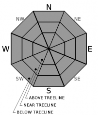
You are here
Avalanche Forecast for 2020-03-21 05:58
- EXPIRED ON March 22, 2020 @ 5:58 amPublished on March 21, 2020 @ 5:58 am
- Issued by Nick Meyers - Shasta-Trinity National Forest
Bottom Line
LOW avalanche danger and normal caution is advised today. Expect variable snow conditions and watch for shallow buried objects.


Avalanche Problem 1: Normal Caution
-
Character ?

-
Aspect/Elevation ?
-
Likelihood ?CertainVery LikelyLikelyPossible
 Unlikely
 -
Size ?HistoricVery LargeLargeSmall

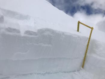
The same, but different! Normal caution is advised. Wear your beacon and carry a shovel and probe. Expect variable snow conditions. Watch for isolated wind slabs and/or loose point releases in steep, extreme terrain. Many shallow buried objects exist below treeline, such as rocks, stumps and bare dirt patches. Tread lightly, or shall I more appropriately say, shred lightly.
Forecast Discussion
If you get out, please send us your observations no matter how brief. You can fill out a snowpack, avalanche or climbing route form, email us at: shastaavalanche@gmail.com or Instagram (@shastaavalanche).
Recent Observations
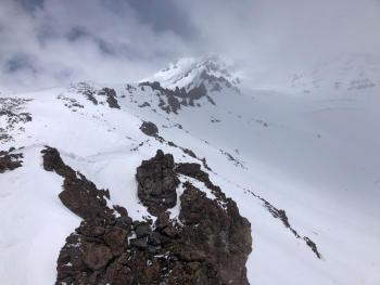
Yesterday was a warm day and the snowpack took a strong hit of sun. Observed was a bit of everything from hot to cold powder, breakable crust, sticky snow, gloppy skins...you name it, it was out there. A breakable sun crust likely expanded its territory by a lot. No major instabilities were observed; a few minor roller balls here and there on those sunny aspects. Winds were light and variable on the west side. Temperatures at treeline over the past 24 hours have ranged from 19 to 34 degrees F. Wind at 8,000 feet on the south side of the mountain (Gray Butte) has averaged 13 mi/hr with gusts to 25 mi/hr. Some wind transport of snow was observed on the upper mountain. Small pockets of surface hoar has developed across the forecast area below and near treeline, but will likely get destroyed by sun before the next storm.
Weather and Current Conditions
Weather Summary
Expect clear, sunny skies and calm wind this morning. A weak, upper level disturbance will move into the area from the north today. This combined with moisture will bring a chance for isolated showers over the mountains this afternoon. Forecasts are also calling for a slight chance of thunderstorms, late afternoon/early evening. All this will diminish overnight. Sunday will host mainly dry weather with continued mild daytime conditions and light wind.
24 Hour Weather Station Data @ 3:00 AM
| Weather Station | Temp (°F) | Wind (mi/hr) | Snow (in) | Comments | ||||||||
|---|---|---|---|---|---|---|---|---|---|---|---|---|
| Cur | Min | Max | Avg | Avg | Max Gust | Dir | Depth | New | Water Equivalent | Settlement | ||
| Mt. Shasta City (3540 ft) | 31 | 24 | 56 | 39.5 | 1 | N | ||||||
| Sand Flat (6750 ft) | 25 | 17 | 42 | 29 | 44 | 0 | 0 | 1 | ||||
| Ski Bowl (7600 ft) | 30.5 | 19.5 | 34 | 29.5 | 69.6 | 0 | 0 | 0 | ||||
| Gray Butte (8000 ft) | 29 | 23 | 33 | 29 | 13 | 25 | ESE | |||||
| Castle Lake (5870 ft) | 33 | 28 | 49.5 | 38.5 | 39.1 | 0 | 1.8 | |||||
| Mount Eddy (6509 ft) | 27 | 20.5 | 39 | 31 | 2 | 9 | WSW | 55.2 | 0 | 1 | ||
| Ash Creek Bowl (7250 ft) | down | |||||||||||
| Ash Creek Ridge (7895 ft) | down |
Two Day Mountain Weather Forecast
Produced in partnership with the Medford NWS
| For 7000 ft to 9000 ft | |||
|---|---|---|---|
|
Saturday (4 a.m. to 10 p.m.) |
Saturday Night (10 p.m. to 4 a.m.) |
Sunday (4 a.m. to 10 p.m.) |
|
| Weather | Sunny this morning, then partly cloudy with a 20% chance of snow showers this afternoon. Snow levels near 5,500 feet. | Partly cloudy with a slight chance of snow showers in the evening, then mostly clear after midnight. | Sunny |
| Temperature (°F) | 40 | 26 | 43 |
| Wind (mi/hr) | Northeast 0-5 | Northwest 0-5 | Southeast 0-5 |
| Precipitation SWE / Snowfall (in) | 0.00 / 0 | 0.00 / 0 | 0.00 / 0 |
| For 9000 ft to 11000 ft | |||
| Saturday | Saturday Night | Sunday | |
| Weather | Sunny, then chance of snow showers. Some thunder is also possible. | Mostly clear, slight chance of showers, some thunder possible also. | Sunny |
| Temperature (°F) | 18 | 17 | 20 |
| Wind (mi/hr) | East 5-10 | Northeast 5-10 | Southeast 5-10 |
| Precipitation SWE / Snowfall (in) | 0.00 / 0 | 0.00 / 0 | 0.00 / 0 |
Season Precipitation for Mount Shasta City
| Period | Measured (in) | Normal (in) | Percent of Normal (%) |
|---|---|---|---|
| From Oct 1, 2025 (the wet season) | 14.84 | 33.88 | 44 |
| Month to Date (since Jun 1, 2026) | 1.94 | 4.38 | 44 |
| Year to Date (since Jan 1, 2026) | 5.91 | 18.67 | 32 |

