

You are here
Avalanche Forecast for 2020-03-22 06:45
- EXPIRED ON March 23, 2020 @ 6:45 amPublished on March 22, 2020 @ 6:45 am
- Issued by Ryan Sorenson - Mount Shasta Avalanche Center
Bottom Line
Avalanche danger is LOW. Exercise normal caution. Variable snow conditions exist.


Avalanche Problem 1: Normal Caution
-
Character ?

-
Aspect/Elevation ?
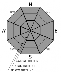
-
Likelihood ?CertainVery LikelyLikelyPossible
 Unlikely
 -
Size ?HistoricVery LargeLargeSmall

Normal caution is advised with LOW avalanche danger expected throughout the region. Remember, LOW avalanche danger does not mean NO avalanche danger. Always wear your beacon and carry a shovel and probe. Watch for isolated wind slabs and/or loose point releases in steep, extreme terrain. Expect variable snow conditions and watch for shallowly buried objects such as rocks, stumps, and bushes.
Forecast Discussion
As we move into spring, surprise afternoon thunderstorms become a common occurrence. Visibility can decrease rapidly. Climbers and sliders may quickly become disoriented on the upper mountain in whiteout conditions. Monitor the weather as you climb and DO NOT CLIMB INTO A WHITEOUT! Carry proper navigation tools and know how to use them.
You need a Mount Shasta summit pass if traveling above 10,000 feet. A wilderness permit and human waste packout bag are also required. All of these items are available for self-issue at the Bunny Flat trailhead or Mount Shasta Ranger Station. Annual passes are available at the ranger station during business hours (Mon-Fri, 8 a.m - 4:30 p.m.).
Recent Observations
Temperatures at treeline over the past 24 hours have ranged from 27 to 36.5 degrees F. Wind at 8,000 feet on the south side of the mountain (Gray Butte) has averaged 7 mi/hr with gusts to 25 mi/hr.
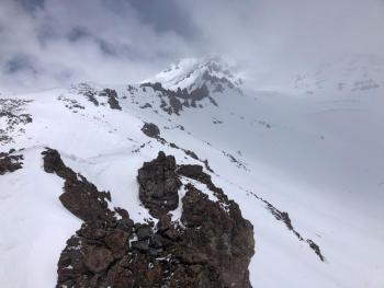
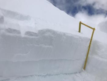
Sunny skies lured many to get out in nature while they maintained social distancing. A surprise snow flurry blew in around noon. During a tour up Casaval Ridge to 9,800 feet, approximately an inch of fresh snow fell between 1130 and 1400 hours. It was possible to find a turn or two in light powdery snow if you searched for it. However, the majority of the snowpack on the south side of Mount Shasta hosts melt-freeze crusts, some supportable some not. South and east-facing aspects hold the best chance for finding supportable snow.
Reports from the east side of Mount Shasta indicate a variable snowpack. North facing slopes had some light powdery snow. Small pockets of surface hoar formed in protected areas. South-facing aspects are thin, with bare spots under the trees. A bit of dirt riding is required to access the Ash Creek Butte area.
Weather and Current Conditions
Weather Summary
Anticipate sunny skies and calm winds today. There is a slight chance of building clouds and brief snow showers in the afternoon. In the next 24 hours, expect less than an inch of snow with snow levels near 5,700 feet.
Expect strong winds above treeline tomorrow. Snow showers are likely. Optimistically speaking, up to three inches of snow will accumulate above 5,000 feet. Expect continued and increasing snow showers on Tuesday. Clearer weather returns Wednesday.
24 Hour Weather Station Data @ 6:00 AM
| Weather Station | Temp (°F) | Wind (mi/hr) | Snow (in) | Comments | ||||||||
|---|---|---|---|---|---|---|---|---|---|---|---|---|
| Cur | Min | Max | Avg | Avg | Max Gust | Dir | Depth | New | Water Equivalent | Settlement | ||
| Mt. Shasta City (3540 ft) | 31 | 24 | 56 | 39.5 | 1 | N | ||||||
| Sand Flat (6750 ft) | 23 | 23 | 42 | 30 | 42 | 0 | 0 | 1 | ||||
| Ski Bowl (7600 ft) | 29 | 27 | 36.5 | 31 | 69 | 0 | 0.04 | 0.8 | ||||
| Gray Butte (8000 ft) | 29.5 | 27.5 | 36 | 31 | 5 | 25 | ESE | |||||
| Castle Lake (5870 ft) | 33.5 | 32 | 50.5 | 39 | 37.3 | 0 | 0 | |||||
| Mount Eddy (6509 ft) | 26.5 | 26 | 41 | 34 | 2 | 9 | WSW | 53.8 | 0 | 1 | ||
| Ash Creek Bowl (7250 ft) | down | |||||||||||
| Ash Creek Ridge (7895 ft) | down |
Two Day Mountain Weather Forecast
Produced in partnership with the Medford NWS
| For 7000 ft to 9000 ft | |||
|---|---|---|---|
|
Sunday (4 a.m. to 10 p.m.) |
Sunday Night (10 p.m. to 4 a.m.) |
Monday (4 a.m. to 10 p.m.) |
|
| Weather | Sunny. | Mostly clear. Slight chance of snow showers in the evening. Snow level near 5,700 feet. | Mostly cloudy. Breezy. Chance of snow in the morning, then snow likely in the afternoon. |
| Temperature (°F) | 42 | 26 | 37 |
| Wind (mi/hr) | East 0-5 | Southwest 0-5 | South 10-15 |
| Precipitation SWE / Snowfall (in) | 0.00 / 0 | 0.00 / 0-1 | 0.02 / 1-2 |
| For 9000 ft to 11000 ft | |||
| Sunday | Sunday Night | Monday | |
| Weather | Sunny. | Mostly clear, slight chance of showers. | Mostly cloudy. Chance of snow in the morning, then snow likely in the afternoon. Strong winds. |
| Temperature (°F) | 23 | 21 | 21 |
| Wind (mi/hr) | Southeast 5-10 | Southwest 5-10 | Southwest 35-40 |
| Precipitation SWE / Snowfall (in) | 0.00 / 0 | 0.00 / 0-1 | 0.02 / 1-2 |
Season Precipitation for Mount Shasta City
| Period | Measured (in) | Normal (in) | Percent of Normal (%) |
|---|---|---|---|
| From Oct 1, 2025 (the wet season) | 14.85 | 34.04 | 44 |
| Month to Date (since Jun 1, 2026) | 1.95 | 4.54 | 43 |
| Year to Date (since Jan 1, 2026) | 5.92 | 18.83 | 31 |

