

You are here
Avalanche Forecast for 2020-03-24 06:00
- EXPIRED ON March 25, 2020 @ 6:00 amPublished on March 24, 2020 @ 6:00 am
- Issued by Aaron Beverly - Mount Shasta Avalanche Center
Bottom Line
Avalanche danger will rise to MODERATE by tonight as 3-6 inches of new snow combines with winds to create slabs near and above treeline. Evaluate wind, snow and leeward terrain carefully as today's storm progresses.


Avalanche Problem 1: Wind Slab
-
Character ?

-
Aspect/Elevation ?
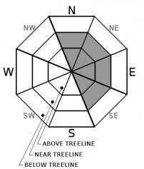
-
Likelihood ?CertainVery LikelyLikelyPossible
 Unlikely
 -
Size ?HistoricVery LargeLargeSmall

Moderate southwest and west winds may combine with 3-6 inches of new snow to create wind slabs. These may sit on top of smooth, firm snow and will not be well bonded to the old snow. Winds slabs are often lens shaped and hollow sounding. Look for them on leeward slopes.
Shooting cracks, whumphing, and blocking indicate a nearby wind slab problem. Look for these signs by stomping on small rollovers and in wind drifts as you travel in safe terrain.
Recent Observations
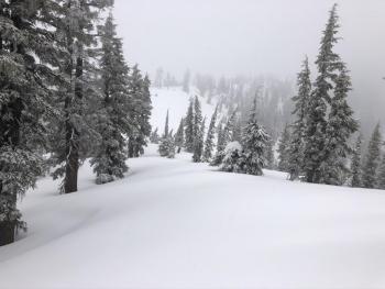
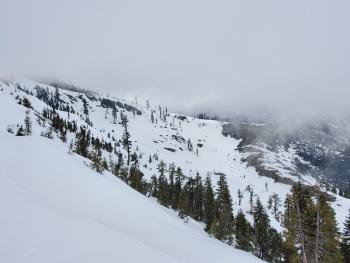
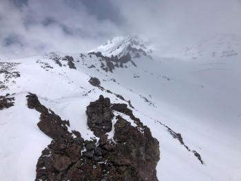
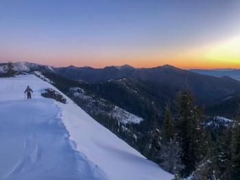
A trace of snow has fallen near treeline overnight on Mount Shasta. The snowfall appears to be turning on now. Temperatures have steadily dropped from 29 to 19 degrees. Winds have been mostly light and out of the west.
Above treeline snow surfaces have been a mixed bag with really nothing of interest to be found inside: mushy and sticky snow with a bit of breakable crust. Yuck!
Castle Lake still has a marginally useful snowpack. All new snow received last week has turned to several inches of mush. Wet-loose slides and large rollerballs could be triggered on steep slopes. Snow surfaces were smooth, though, and dropping temperatures will turn these into ideal bed surfaces.
Weather and Current Conditions
Weather Summary
High and low pressure are working together to squeeze cold air in from Alaska. With it, comes 3-6 inches of snow above 3,000 ft by tonight. Southwest and west winds will be moderate near and above treeline.
A bit more snow could fall tomorrow. Temperatures should remain cold throughout the week.
24 Hour Weather Station Data @ 3:00 AM
| Weather Station | Temp (°F) | Wind (mi/hr) | Snow (in) | Comments | ||||||||
|---|---|---|---|---|---|---|---|---|---|---|---|---|
| Cur | Min | Max | Avg | Avg | Max Gust | Dir | Depth | New | Water Equivalent | Settlement | ||
| Mt. Shasta City (3540 ft) | 34 | 29 | 62 | 45.5 | 0 | N | ||||||
| Sand Flat (6750 ft) | 23 | 23 | 34 | 30 | 42 | 0 | 0 | 0 | ||||
| Ski Bowl (7600 ft) | 19.5 | 19.5 | 30.5 | 26 | 68.6 | 0 | 0.01 | 0.5 | ||||
| Gray Butte (8000 ft) | 16.5 | 16.5 | 26.5 | 23 | 13 | 31 | WSW | |||||
| Castle Lake (5870 ft) | 25.5 | 25.5 | 42 | 33.5 | 35.7 | 0 | 0.2 | |||||
| Mount Eddy (6509 ft) | 20.5 | 20.5 | 40.5 | 30 | 2 | 11 | S | 52.1 | 0 | 0.5 | ||
| Ash Creek Bowl (7250 ft) | down | |||||||||||
| Ash Creek Ridge (7895 ft) | down |
Two Day Mountain Weather Forecast
Produced in partnership with the Medford NWS
| For 7000 ft to 9000 ft | |||
|---|---|---|---|
|
Tuesday (4 a.m. to 10 p.m.) |
Tuesday Night (10 p.m. to 4 a.m.) |
Wednesday (4 a.m. to 10 p.m.) |
|
| Weather | Snow showers. Chance of precipitation is 90%. | Mostly cloudy, with a low around 17. | Snow showers likely after 11 a.m. Partly sunny. Chance of precipitation is 60%. |
| Temperature (°F) | 26 | 17 | 27 |
| Wind (mi/hr) | Southwest 10-15 | West 5-10 | West 5-10 |
| Precipitation SWE / Snowfall (in) | 0.36 / 3-6 | 0.01 / 0-0.50 | 0.07 / 0-1 |
| For 9000 ft to 11000 ft | |||
| Tuesday | Tuesday Night | Wednesday | |
| Weather | Snow showers. Windy. Low wind chills. Chance of precipitation is 90%. | Cloudy, then gradually becoming partly cloudy. Breezy. Low wind chills. | Snow showers likely after 11 a.m. Partly sunny and cold. Chance of precipitation is 60%. |
| Temperature (°F) | 11 | 6 | 9 |
| Wind (mi/hr) | Southwest 20-25 | West 15-20 | Northwest 10-15 |
| Precipitation SWE / Snowfall (in) | 0.36 / 3-6 | 0.01 / 0-0.50 | 0.07 / 0-1 |
Season Precipitation for Mount Shasta City
| Period | Measured (in) | Normal (in) | Percent of Normal (%) |
|---|---|---|---|
| From Oct 1, 2025 (the wet season) | 14.85 | 34.36 | 43 |
| Month to Date (since Jun 1, 2026) | 1.95 | 4.86 | 40 |
| Year to Date (since Jan 1, 2026) | 5.92 | 19.15 | 31 |

