

You are here
Avalanche Forecast for 2020-03-26 06:00
- EXPIRED ON March 27, 2020 @ 6:00 amPublished on March 26, 2020 @ 6:00 am
- Issued by Aaron Beverly - Mount Shasta Avalanche Center
Bottom Line
Avalanche danger is LOW. Overall, safe avalanche conditions exist, but continue to be cautious of small, isolated wind slabs in steep, leeward terrain. It'll be a sunny, cool day. Showery weather returns Friday night.


Avalanche Problem 1: Wind Slab
-
Character ?

-
Aspect/Elevation ?
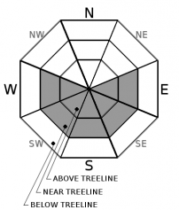
-
Likelihood ?CertainVery LikelyLikelyPossible
 Unlikely
 -
Size ?HistoricVery LargeLargeSmall

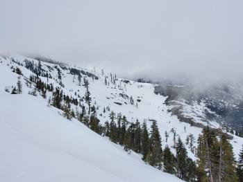
Avalanche danger is LOW. There is still snow out there available for transport, though winds today are unlikely to be blowing it. Nonetheless, continue to pay attention to steep, leeward slopes and blowing snow. There may be some small, isolated wind slabs out there. If you find them, they'll be lens shaped, at the top of start zones, and will crack under your feet. Test for them on rollovers above areas of no consequence.
Recent Observations
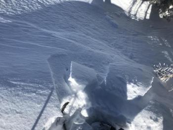
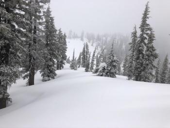
In the last 24 hours, about an inch of snow fell near treeline on Mount Shasta. Winds were variable and light, peaking at 9 mph. Temperatures ranged from 10 to 26 degrees.
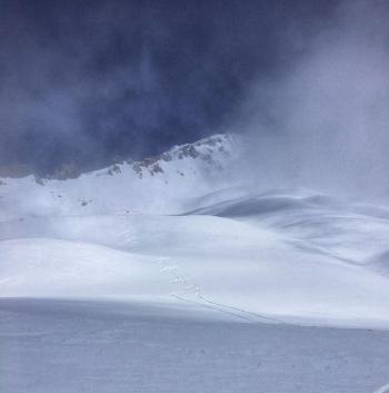
On Mount Shasta, about 3-6 inches of low density snow exists as you transition from below to above treeline. There is some light wind affect above treeline but no notable signs of wind slab formation. There is still snow available for transport.
Weather and Current Conditions
Weather Summary
Colder temperatures should stick around for the next couple of days. Snow levels will remain near 3,000 ft, though no snow is expected. Low clouds this morning should break into a clear, sunny day by 10 a.m.
Showery conditions return Friday night. Near 0.3 inches of precipitable water and 4,000 ft snow levels should give us another refresh to our struggling snowpack.
24 Hour Weather Station Data @ 4:00 AM
| Weather Station | Temp (°F) | Wind (mi/hr) | Snow (in) | Comments | ||||||||
|---|---|---|---|---|---|---|---|---|---|---|---|---|
| Cur | Min | Max | Avg | Avg | Max Gust | Dir | Depth | New | Water Equivalent | Settlement | ||
| Mt. Shasta City (3540 ft) | 30 | 23 | 41 | 33 | 2 | |||||||
| Sand Flat (6750 ft) | 9 | 9 | 28 | 19 | 44 | 1 | 0.04 | 1 | ||||
| Ski Bowl (7600 ft) | 13 | 9 | 26 | 16.5 | 73.4 | 1 | 0.09 | 0.3 | ||||
| Gray Butte (8000 ft) | 13 | 11 | 23 | 17 | 4 | 18 | WNW | |||||
| Castle Lake (5870 ft) | 19 | 17 | 34 | 24.5 | 0 | 0 | 0 | |||||
| Mount Eddy (6509 ft) | 17 | 9.5 | 26 | 19.5 | 2 | 8 | ESE | 60.7 | 0 | 0 | ||
| Ash Creek Bowl (7250 ft) | down | |||||||||||
| Ash Creek Ridge (7895 ft) | down |
Two Day Mountain Weather Forecast
Produced in partnership with the Medford NWS
| For 7000 ft to 9000 ft | |||
|---|---|---|---|
|
Thursday (4 a.m. to 10 p.m.) |
Thursday Night (10 p.m. to 4 a.m.) |
Friday (4 a.m. to 10 p.m.) |
|
| Weather | Sunny. | Mostly clear. | Partly sunny. |
| Temperature (°F) | 31 | 20 | 34 |
| Wind (mi/hr) | North 5-10 | Northwest 5-10 | West 5-10 |
| Precipitation SWE / Snowfall (in) | 0.00 / 0 | 0.00 / 0 | 0.00 / 0 |
| For 9000 ft to 11000 ft | |||
| Thursday | Thursday Night | Friday | |
| Weather | Sunny. | Mostly clear. | Partly sunny. Breezy. |
| Temperature (°F) | 13 | 13 | 17 |
| Wind (mi/hr) | North 10-15 | Northwest 10-15 | West 15-20 |
| Precipitation SWE / Snowfall (in) | 0.00 / 0 | 0.00 / 0 | 0.00 / 0 |
Season Precipitation for Mount Shasta City
| Period | Measured (in) | Normal (in) | Percent of Normal (%) |
|---|---|---|---|
| From Oct 1, 2025 (the wet season) | 14.95 | 34.65 | 43 |
| Month to Date (since Jun 1, 2026) | 2.05 | 5.15 | 40 |
| Year to Date (since Jan 1, 2026) | 6.02 | 19.44 | 31 |

