

You are here
Avalanche Forecast for 2020-03-30 06:50
- EXPIRED ON March 31, 2020 @ 6:50 amPublished on March 30, 2020 @ 6:50 am
- Issued by Ryan Sorenson - Mount Shasta Avalanche Center
Bottom Line
Avalanche danger is CONSIDERABLE. Up to 10 inches of new snow will combine with moderate to strong southwesterly winds. Large, human triggered wind slab avalanches are likely above treeline. Storm slab avalanches may develop in steep below and near treeline terrain as heavy, moist snow falls atop slightly less dense snow that fell earlier in this storm. Carefully evaluate the snowpack, wind, and terrain.


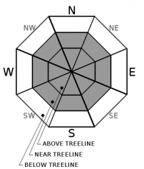
Avalanche Problem 1: Wind Slab
-
Character ?

-
Aspect/Elevation ?
-
Likelihood ?CertainVery LikelyLikelyPossible
 Unlikely
 -
Size ?HistoricVery LargeLargeSmall

Existing and new snow (up to 10 inches) will combine with moderate to strong southwest and west wind to create wind slabs. The size and distribution of wind slabs will increase today. In addition to fresh snow, some areas above treeline on Mount Shasta host up to a foot of light snow available for transport. Loaded leeward N-NE-E-SE-S aspects are most suspect; however, wind direction can change as terrain features create eddies and varying wind behavior. Triggering a large wind slab avalanche is likely above treeline and possible near treeline on wind loaded slopes today.
Identify wind slabs by looking for new cornice development, and pillows of wind drifted snow. Winds slabs are often lens-shaped and hollow sounding. Shooting cracks, whumping, and blocking indicate a nearby wind slab problem. Avoid them by sticking to protected or wind-scoured areas. Some blocking and shooting cracks were observed yesterday.
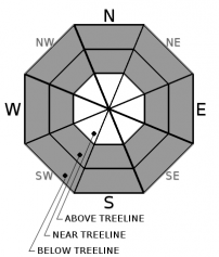
Avalanche Problem 2: Storm Slab
-
Character ?

-
Aspect/Elevation ?
-
Likelihood ?CertainVery LikelyLikelyPossible
Unlikely
-
Size ?HistoricVery LargeLargeSmall
Steep areas below and near treeline may host a storm slab problem as heavy, moist snow falls atop slightly less dense snow that fell earlier in this storm. Slopes steeper than 40 degrees are most suspect. A storm slab avalanche is the release of a soft, cohesive layer of new snow that breaks within the storm snow or on the old snow surface. You can reduce your risk from storm slabs by waiting a day or two after a storm before venturing into steep terrain. Storm slabs are most dangerous on slopes with terrain traps below.
Ski cuts above short, steep areas of no consequence are the best way to test for this problem.
Forecast Discussion
Pay attention to the five red flags of avalanche danger:
- Recent avalanches
- New snow *
- Collapsing, cracking, or blocking *
- Blowing snow *
- Rapid temperature rise *
Recent Observations
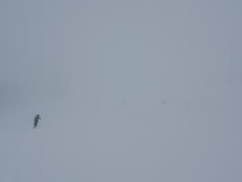
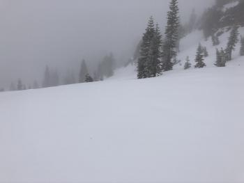
Yesterday, Mount Shasta hosted a slightly warmer and somewhat balmy day. Low clouds, foggy, moist, and generally low visibility lingered for most of the morning. A brief clearing occurred around 1300 hours during our tour on Lower Casaval Ridge, giving us a short window to ski through. Light snow was falling from the sky for most of the day however, it was very light and little new accumulation was observed. Approximately 3 to 6 inches of fresh snow sits atop a thin and variable melt-freeze crust. An icy, firm and consolidated snowpack exist below. Some minor blocking and cracking was observed on a steep ridgeline above treeline. Snow surfaces were quickly changing. Cold powdery snow could be found in protected areas and higher elevations (above 8,500 feet). However, moist, sticky, cream cheese-like snow was observed below treeline. Calm winds were observed throughout the day on Mount Shasta. Reports for the Eddies indicate stronger winds, stiff 1F hard wind slabs forming on lower angle terrain, and sticky moist snow with large rollerballs on easterly facing slopes.
In the last 24 hours:
- Snow accumulation of 1.5 inches (.23' SWE) was recorded at the Old Ski Bowl Weather station.
- Winds have averaged 11 mi/hr with gusts to 31 mi/hr out of the west/northwest.
- Temperatures at treeline maxed at 32F, with a low of 22F.
Weather and Current Conditions
Weather Summary
A sizeable pulse of snow showers will bring significant snowfall and wind today. Models show .56 inches of snow/water equivalent is expected in the next 24 hours, which equates to 5-10 inches of more fresh snow by Tuesday. Strong winds will gain strength throughout and have a southerly and westerly flow. The temperature will be around freezing below and near treeline. Expect above treeline temperatures in the low twenties. Snow levels will be in the 4,500 to 5,500 foot range with this storm.
The faucet will gradually turn off Tuesday afternoon. Expect some lingering snow showers. Cold and clear weather is in store for Wednesday.
24 Hour Weather Station Data @ 6:00 AM
| Weather Station | Temp (°F) | Wind (mi/hr) | Snow (in) | Comments | ||||||||
|---|---|---|---|---|---|---|---|---|---|---|---|---|
| Cur | Min | Max | Avg | Avg | Max Gust | Dir | Depth | New | Water Equivalent | Settlement | ||
| Mt. Shasta City (3540 ft) | 40 | 37 | 48 | 42 | 2 | ESE | ||||||
| Sand Flat (6750 ft) | 29 | 26 | 34 | 30 | 48 | 1 | 0.08 | 0 | ||||
| Ski Bowl (7600 ft) | 25.5 | 22 | 32 | 26.5 | 79.3 | 1.5 | 0.23 | 0 | ||||
| Gray Butte (8000 ft) | 24 | 21 | 31 | 26 | 12 | 31 | W | |||||
| Castle Lake (5870 ft) | 30 | 27 | 41 | 33.5 | 38.4 | 0 | 0 | |||||
| Mount Eddy (6509 ft) | 27 | 26 | 33 | 29.5 | 2 | 10 | SSE | 58.1 | 2 | 0 | ||
| Ash Creek Bowl (7250 ft) | down | |||||||||||
| Ash Creek Ridge (7895 ft) | down |
Two Day Mountain Weather Forecast
Produced in partnership with the Medford NWS
| For 7000 ft to 9000 ft | |||
|---|---|---|---|
|
Monday (4 a.m. to 10 p.m.) |
Monday Night (10 p.m. to 4 a.m.) |
Tuesday (4 a.m. to 10 p.m.) |
|
| Weather | Breezy, cloudy. Snow in the morning, then snow in the afternoon. Snow level near 4,900 feet | Breezy. Snow. Snow level near 5,500 feet. | Breezy, cloudy. Snow in the morning, then a chance of snow showers in the afternoon. Snow level near 5,100 feet |
| Temperature (°F) | 35 | 31 | 36 |
| Wind (mi/hr) | South 15-20 | Southwest 15-20 | Southwest 10-15 |
| Precipitation SWE / Snowfall (in) | 0.49 / 4-8 | 0.07 / 1-2 | 0.04 / 1-2 |
| For 9000 ft to 11000 ft | |||
| Monday | Monday Night | Tuesday | |
| Weather | Snow. Breezy. | Snow. Breezy. | Snow showers. |
| Temperature (°F) | 21 | 17 | 17 |
| Wind (mi/hr) | Southwest 35-40 | Southwest 40-45 | West 15-20 |
| Precipitation SWE / Snowfall (in) | 0.49 / 5-10 | 0.07 / 1-3 | 0.04 / 1-2 |
Season Precipitation for Mount Shasta City
| Period | Measured (in) | Normal (in) | Percent of Normal (%) |
|---|---|---|---|
| From Oct 1, 2025 (the wet season) | 14.98 | 35.20 | 43 |
| Month to Date (since Jun 1, 2026) | 2.08 | 5.70 | 36 |
| Year to Date (since Jan 1, 2026) | 6.05 | 19.99 | 30 |

