

You are here
Avalanche Forecast for 2020-04-05 07:00
- EXPIRED ON April 6, 2020 @ 7:00 amPublished on April 5, 2020 @ 7:00 am
- Issued by Ryan Sorenson - Mount Shasta Avalanche Center
Bottom Line
Winter storm warnings remain in effect today as a powerful spring storm continues to impact the mountains. Over a foot of new snow was received in the last 24 hours and another foot is expected today. Southerly flow will bring periods of heavy precipitation and windy conditions. Avalanche danger is CONSIDERABLE. Natural and human triggered avalanches are likely. Mindful terrain choice will be imperative today.


Avalanche Problem 1: Wind Slab
-
Character ?

-
Aspect/Elevation ?
-
Likelihood ?CertainVery LikelyLikelyPossible
 Unlikely
 -
Size ?HistoricVery LargeLargeSmall

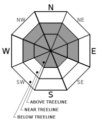
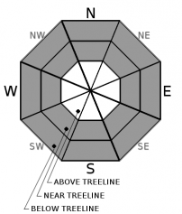
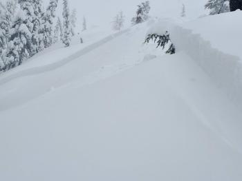
Continued strong winds out of the south/southeast will combine with new snow today. We have received over a foot of new snow in the last 24 hours and another foot is forecast today. Expect active wind loading and large wind slabs formation. Wind slabs are expected on northerly and westerly aspects, but variable mountain winds and cross-loading could allow them to form in other areas. Triggering a large wind slab avalanche is likely in near and above treeline terrain. Wind slabs could grow very large in isolated steep wind loaded areas. Large natural avalanches are possible.
Pay attention to where leeward areas reside and stay away from steep slopes that have been loaded. Look for signs of wind slabs as you travel in safe terrain:
- Shooting cracks, blocking, whumphing
- Convex pillows of wind-drifted snow
- New cornice development
- Chalky, hollow sounding snow
Avalanche Problem 2: Storm Slab
-
Character ?

-
Aspect/Elevation ?
-
Likelihood ?CertainVery LikelyLikelyPossible
Unlikely
-
Size ?HistoricVery LargeLargeSmall
Steep areas below and near treeline may host a storm slab problem today. This type of avalanche is found below treeline and protected near treeline areas.
Storm slabs form when snow falls and consolidates atop slightly less dense snow that fell earlier in the storm. A storm slab avalanche is the release of a soft, cohesive layer of new snow that breaks within the storm snow or atop the old snow surface. Slopes steeper than 40 degrees are most suspect. You can reduce your risk from storm slabs by waiting a day or two after a storm before venturing into steep terrain.
Forecast Discussion
COVID-19 Information - Updated 4.3.2020
A statewide shelter-in-place order exists for ALL citizens. It is critical that we comply with this order. We recommend exercising close to home and complying with local and state guidelines. Please, do no travel for your recreation needs.
At the Mount Shasta Avalanche Center, we always encourage people to get information before planning or heading out for a day in the backcountry. We emphasize that you need to match your plan to the current conditions. Usually, we talk about current snow, weather and avalanche conditions. These are not usual times: now, you need to think about public health conditions.
If you choose to recreate in the mountains, remember your actions may impact others. Please enjoy the backcountry safely, and keep our communities, medical and emergency services professionals, and fellow backcountry users in mind when you consider your terrain choices.
Recent Observations
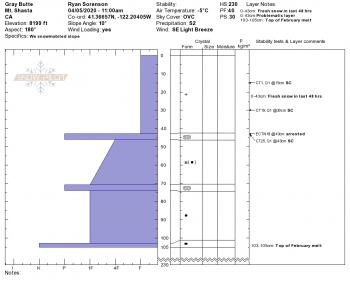
Snow started falling at 0700 yesterday (04.04.2020) and we have received almost continuous snowfall for the past 24 hours. A tour up Green Butte Ridge (Broadway) observed light to moderate snowfall (1100-1400 hrs). At that time, up to 4 inches of new snow sat atop a mostly supportable crust. Light south wind was loading west aspects. Drifts up to a foot deep were forming along the ridge. Small test slopes showed that wind slabs were easily triggered on westerly slopes. These wind slabs were blocking and cracking in the top 1 to 3 inches of fresh snow. A pit dug at 8,200 feet near treeline had column tests that showed instability within the first few inches of new snow as well as at the new/old snow interface (CT8 ⬇ 8 cm, CT11 ⬇ 14 cm, ECTN ⬇ 14 cm).
In the last 24 hours,
- The Old Ski Bowl weather station has received 12.7 inches of snow (1.04 SWE).
- Temperatures at treeline have ranged from 20 to 25 deg F.
- Wind average 12 mi/hr with gusts to 31 mi/hr at 8,000 feet, South/Southwest.
Weather and Current Conditions
Weather Summary
A winter storm warning remains in effect until 5 PM PDT today. Stormy weather will continue to bring periods of moderate to heavy snowfall. So far, over one inch of water has fallen as snow above 4,000 feet. This has accumulated over a foot of new snow at our Old Ski Bowl weather station at 7,600 feet in the last 24 hours.
Models show slightly over an inch of water remaining with this storm. Snow levels will hover between 4,000 and 5,000 feet. We can expect another foot of fresh snow by Monday morning. Strong southerly winds will combine with widespread snow showers today. There is a chance that some thunderstorms may produce small hail this afternoon. Dryer conditions will return towards the end of the workweek.
24 Hour Weather Station Data @ 5:00 AM
| Weather Station | Temp (°F) | Wind (mi/hr) | Snow (in) | Comments | ||||||||
|---|---|---|---|---|---|---|---|---|---|---|---|---|
| Cur | Min | Max | Avg | Avg | Max Gust | Dir | Depth | New | Water Equivalent | Settlement | ||
| Mt. Shasta City (3540 ft) | 35 | 33 | 40 | 35.5 | 3 | ESE | ||||||
| Sand Flat (6750 ft) | 27 | 25 | 29 | 27 | 51 | 0 | 0 | 0 | ||||
| Ski Bowl (7600 ft) | 22.5 | 20.5 | 25 | 23.5 | 93 | 12.7 | 1.04 | 0 | ||||
| Gray Butte (8000 ft) | 22 | 18.5 | 24 | 22 | 12 | 31 | SW | |||||
| Castle Lake (5870 ft) | 28.5 | 26 | 35.5 | 29.5 | 49.2 | 10.1 | 0 | |||||
| Mount Eddy (6509 ft) | 26 | 25.5 | 28.5 | 27 | 2 | 15 | S | 66 | 8.1 | 0 | ||
| Ash Creek Bowl (7250 ft) | down | |||||||||||
| Ash Creek Ridge (7895 ft) | down |
Two Day Mountain Weather Forecast
Produced in partnership with the Medford NWS
| For 7000 ft to 9000 ft | |||
|---|---|---|---|
|
Sunday (4 a.m. to 10 p.m.) |
Sunday Night (10 p.m. to 4 a.m.) |
Monday (4 a.m. to 10 p.m.) |
|
| Weather | Snow. Breezy. Scattered thunderstorms with small hail possible. Snow level near 4,600 feet. | Mostly cloudy. Snow showers likely in the evening, then chance of snow showers after midnight. | Partly cloudy. A 30 percent chance of snow showers. |
| Temperature (°F) | 32 | 23 | 37 |
| Wind (mi/hr) | South 10-15 | South 5-10 | North 0-5 |
| Precipitation SWE / Snowfall (in) | 1.03 / 7-11 | 0.05 / 1-2 | 0.04 / 0-1 |
| For 9000 ft to 11000 ft | |||
| Sunday | Sunday Night | Monday | |
| Weather | Snow. Breezy. Scattered thunderstorms with small hail possible. | Mostly cloudy. Snow showers likely in the evening, then chance of snow showers after midnight. | Partly cloudy. A chance of snow showers. |
| Temperature (°F) | 19 | 16 | 24 |
| Wind (mi/hr) | South 30-40 | Southeast 15-20 | East 10-15 |
| Precipitation SWE / Snowfall (in) | 1.03 / 8-12 | 0.05 / 1-2 | 0.04 / 0-1 |
Season Precipitation for Mount Shasta City
| Period | Measured (in) | Normal (in) | Percent of Normal (%) |
|---|---|---|---|
| From Oct 1, 2025 (the wet season) | 15.85 | 35.92 | 44 |
| Month to Date (since Jun 1, 2026) | 0.68 | 0.46 | 148 |
| Year to Date (since Jan 1, 2026) | 6.92 | 20.71 | 33 |

