

You are here
Avalanche Forecast for 2020-04-06 07:00
- EXPIRED ON April 7, 2020 @ 7:00 amPublished on April 6, 2020 @ 7:00 am
- Issued by Ryan Sorenson - Mount Shasta Avalanche Center
Bottom Line
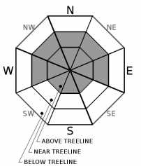
The Mount Shasta area has received approximately two feet of snow in the last 48 hours combined with southerly winds. Human-triggered avalanches involving large slabs remain likely above treeline and possible near treeline. Warming temperature will continue to make storm slabs a concern as heavy, moist snow will sit on top of less dense snow that fell earlier in the storm. CONSIDERABLE avalanche danger exists above treeline and MODERATE avalanche danger near and below.


Avalanche Problem 1: Wind Slab
-
Character ?

-
Aspect/Elevation ?
-
Likelihood ?CertainVery LikelyLikelyPossible
 Unlikely
 -
Size ?HistoricVery LargeLargeSmall

Wind slab avalanches were observed yesterday. Concern for wind slab avalanches remains above treeline today as there is plenty of snow available for transport and lingering wind slabs likely exist. Human triggered wind slabs are possible near treeline.
Identify where wind slabs may exist by looking for wind-scoured ridges, new cornice development, pillows of wind drifted snow, and other wind-sculpted features on the snow surface. Try to figure out the local direction of the wind from these clues and identify areas where loading has occurred. Winds slabs are often lens-shaped and hollow sounding. Shooting cracks, whumping, and blocking indicate a nearby wind slab problem. Avoid them by sticking to protected or wind-scoured areas.
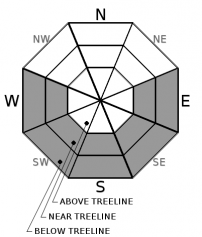
Avalanche Problem 2: Storm Slab
-
Character ?

-
Aspect/Elevation ?
-
Likelihood ?CertainVery LikelyLikelyPossible
Unlikely
-
Size ?HistoricVery LargeLargeSmall
Storm slab avalanches continue to be a concern today. Storm slab avalanches were observed yesterday on steep terrain below and near treeline. As the temperature rises today, heavy, moist snow will sit on top of the slightly less dense snow that fell earlier in this storm. Human triggered avalanches remain possible near and below treeline on slopes steeper than 40 degrees.
A storm slab avalanche is the release of a soft, cohesive layer of new snow that breaks within the storm snow or on the old snow surface. You can reduce your risk from storm slabs by waiting a day or two after a storm before venturing into steep terrain. Storm slabs are most dangerous on slopes with terrain traps below.
Forecast Discussion
Today will host dynamic conditions as the snowpack begins to settle. Though peak avalanche danger likely occurred yesterday, it is imperative to proceed cautiously as we have received a lot of wind and snow with this storm. Remember to pay attention to the five red flags of avalanche danger and adjust your travel plans to avoid areas of concern.
Five red flags of avalanche danger:
- Recent avalanches
- New snow
- Collapsing, cracking, or blocking
- Blowing snow
- Rapid temperature rise
Recent Observations
Over the last 48 hours, we have received nearly continuous snowfall. Our weather station at the Old Ski Bowl (7,600 feet) has recorded 22.2 inches (2.24 SWE). During the last 24 hours, winds near treeline on Gray Butte have averaged 8 mi/hr with gusts to 18 mi/hr out of the southeast.
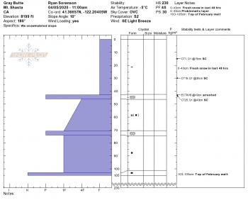
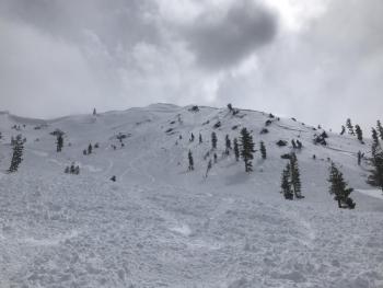
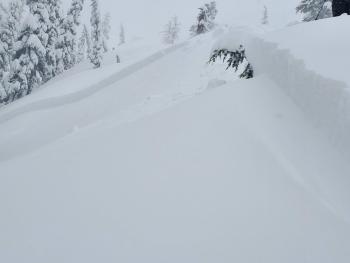
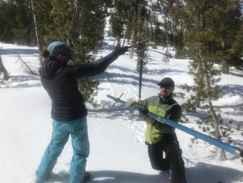
Observations at 8,200 feet near treeline in Old Ski Bowl saw 16 inches of fresh snow over various melt-freeze crusts, some breakable. Column tests showed planar fractures within the new snow 6 and 11 inches deep as well as at the new/old snow interface. On Gray Butte, we observed storm slab avalanches along the prominent east ridgeline. These avalanches (D1.5, R1) had failed within the new snow and slid on a density change down 18 inches. A partial burial was reported in the Eddies from a large wind slab avalanche that occurred near 7,000 feet. No other information was provided.
Weather and Current Conditions
Weather Summary
The weather will begin to clear up today as the storm moves south along the California coast. Light snow showers will linger this morning with snow levels near 4,000 feet. We may see up to an inch of snow accumulation, but the active period in this storm has passed. Expect light winds out of the north.
Warmer temperatures and mostly clear skies will return tomorrow. Highs could reach the mid-40s to lower 50s by mid-afternoon. Sunny dry weather will prevail for the rest of the week.
24 Hour Weather Station Data @ 2:00 AM
| Weather Station | Temp (°F) | Wind (mi/hr) | Snow (in) | Comments | ||||||||
|---|---|---|---|---|---|---|---|---|---|---|---|---|
| Cur | Min | Max | Avg | Avg | Max Gust | Dir | Depth | New | Water Equivalent | Settlement | ||
| Mt. Shasta City (3540 ft) | 33 | 32 | 41 | 34 | 1 | N | ||||||
| Sand Flat (6750 ft) | 24 | 24 | 32 | 27 | 65 | 0 | 0 | 0 | ||||
| Ski Bowl (7600 ft) | 19.5 | 19 | 27.5 | 23 | 103.3 | 10.3 | 1.3 | 0 | ||||
| Gray Butte (8000 ft) | 19 | 19 | 27.5 | 22.5 | 8 | 18 | SE | |||||
| Castle Lake (5870 ft) | 25.5 | 25.5 | 32.5 | 28.5 | 63.2 | 15.8 | 0 | |||||
| Mount Eddy (6509 ft) | 23.5 | 23 | 30.5 | 26 | 1 | 10 | SSW | 83 | 16 | 0 | ||
| Ash Creek Bowl (7250 ft) | down | |||||||||||
| Ash Creek Ridge (7895 ft) | down |
Two Day Mountain Weather Forecast
Produced in partnership with the Medford NWS
| For 7000 ft to 9000 ft | |||
|---|---|---|---|
|
Monday (4 a.m. to 10 p.m.) |
Monday Night (10 p.m. to 4 a.m.) |
Tuesday (4 a.m. to 10 p.m.) |
|
| Weather | Mostly cloudy with scattered snow showers this morning, then partly cloudy with a chance snow showers this afternoon. Snow level near 4,200 feet. | Partly cloudy. A 30 percent chance of snow showers in the evening. . Snow level near 5,800 feet. | Partly cloudy in the morning then clearing. |
| Temperature (°F) | 37 | 28 | 43 |
| Wind (mi/hr) | North 0-5 | North 0-5 | North 0-5 |
| Precipitation SWE / Snowfall (in) | 0.04 / 0-1 | 0.00 / 0-0.50 | 0.00 / 0 |
| For 9000 ft to 11000 ft | |||
| Monday | Monday Night | Tuesday | |
| Weather | Mostly cloudy with scattered snow showers this morning, then partly cloudy with a chance snow showers this afternoon. | Partly cloudy. A 30 percent chance of snow showers in the evening. | Partly cloudy in the morning then clearing. |
| Temperature (°F) | 21 | 21 | 27 |
| Wind (mi/hr) | East 10-15 | Northeast 10-15 | Northeast 10-15 |
| Precipitation SWE / Snowfall (in) | 0.04 / 0-1 | 0.00 / 0-1 | 0.00 / 0 |
Season Precipitation for Mount Shasta City
| Period | Measured (in) | Normal (in) | Percent of Normal (%) |
|---|---|---|---|
| From Oct 1, 2025 (the wet season) | 17.13 | 36.04 | 48 |
| Month to Date (since Jun 1, 2026) | 1.96 | 0.58 | 338 |
| Year to Date (since Jan 1, 2026) | 8.20 | 20.83 | 39 |

