

You are here
Avalanche Forecast for 2020-04-07 06:00
- EXPIRED ON April 8, 2020 @ 6:00 amPublished on April 7, 2020 @ 6:00 am
- Issued by Aaron Beverly - Mount Shasta Avalanche Center
Bottom Line
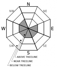
Avalanche danger is MODERATE above treeline due to concern for wind slab avalanches. Continue to approach slopes above 35 degrees with mindfulness. Sunny, warming weather will increase concern for point-releases on steep, sunlit aspects. Clear weather will prevail through the weekend.


Avalanche Problem 1: Wind Slab
-
Character ?

-
Aspect/Elevation ?
-
Likelihood ?CertainVery LikelyLikelyPossible
 Unlikely
 -
Size ?HistoricVery LargeLargeSmall

Moderate east winds blew all night long. With plenty of snow available for transport, new wind slabs may have formed above treeline on westerly facing aspects. There is less concern for old wind slabs. If you encounter cracking or blocking snow in wind drifted areas, skier-triggered avalanches will be possible on nearby slopes above 35 degrees.
Forecast Discussion
As the sun comes out and temperatures rise, sunlit aspects will begin to release roller balls and pinwheels. This is a sign that loose wet avalanches (point-releases/sluffs) may be possible. If slopes are exhibiting these signs, they are best avoided.
The Shasta/Trinity National Forest is under COVID-19 Restrictions. The bathrooms at Bunny Flat are not maintained regularly. Use in case of "emergency". Bring hand sanitizer. Take your trash home with you. Socialize at a distance. Postpone your ski-cation for now.
Recent Observations
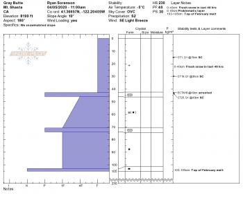
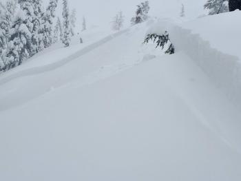
Yesterday, temperatures poked above freezing for about 3 hours. This, combined with a greenhouse effect from thin, low clouds, softened the surface snow. Winds were calm to light above treeline until about 8 p.m. when moderate east winds, 16-23 mi/hr, kicked in and blew all night. Generally very little wind effect was seen above treeline yesterday afternoon. However, some small wind slabs were seen in isolated areas along the top of Casaval Ridge. Hand tests produced easy planar failures in these drifted areas.
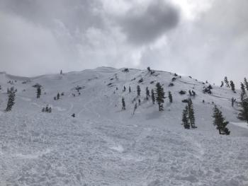
Low visibility limited visuals on the upper mountain though skiers reported seeing debris from a large (D2/D3) avalanche near Helen Lake. A significant wind event observed briefly Sunday afternoon blowing snow onto the Trinity Chutes may be the culprit. We hope to get more information on this today.
Weather and Current Conditions
Weather Summary
Today, expect sunny, warming weather with a high of 45 degrees near treeline. Winds will be light and northerly.
It'll be clear sailing for a while as a high pressure ridge centered over the northeast dominates the weather pattern for the next 7 days. Expect mostly sunny and warmer conditions through the weekend.
24 Hour Weather Station Data @ 4:00 AM
| Weather Station | Temp (°F) | Wind (mi/hr) | Snow (in) | Comments | ||||||||
|---|---|---|---|---|---|---|---|---|---|---|---|---|
| Cur | Min | Max | Avg | Avg | Max Gust | Dir | Depth | New | Water Equivalent | Settlement | ||
| Mt. Shasta City (3540 ft) | 38 | 32 | 49 | 39.5 | 1 | N | ||||||
| Sand Flat (6750 ft) | 22 | 22 | 34 | 29 | 64 | 0 | 0 | 1 | ||||
| Ski Bowl (7600 ft) | 29.5 | 18.5 | 33.5 | 28.5 | 100.3 | 0 | 0.07 | 2.1 | ||||
| Gray Butte (8000 ft) | 31.5 | 18.5 | 32.5 | 28.5 | 12 | 31 | E | |||||
| Castle Lake (5870 ft) | 31.5 | 25 | 39 | 33 | 56.8 | 0 | 6.1 | |||||
| Mount Eddy (6509 ft) | 30.5 | 22 | 34.5 | 29 | 1 | 7 | WSW | 77.1 | 0 | 4.9 | ||
| Ash Creek Bowl (7250 ft) | down | |||||||||||
| Ash Creek Ridge (7895 ft) | down |
Two Day Mountain Weather Forecast
Produced in partnership with the Medford NWS
| For 7000 ft to 9000 ft | |||
|---|---|---|---|
|
Tuesday (4 a.m. to 10 p.m.) |
Tuesday Night (10 p.m. to 4 a.m.) |
Wednesday (4 a.m. to 10 p.m.) |
|
| Weather | Sunny. | Mostly clear. | Sunny. |
| Temperature (°F) | 45 | 28 | 51 |
| Wind (mi/hr) | North 5-10 | Northeast 5-10 | Northeast 10-15 |
| Precipitation SWE / Snowfall (in) | 0.00 / 0 | 0.00 / 0 | 0.00 / 0 |
| For 9000 ft to 11000 ft | |||
| Tuesday | Tuesday Night | Wednesday | |
| Weather | Sunny. | Mostly clear. | Sunny. Breezy. |
| Temperature (°F) | 27 | 27 | 32 |
| Wind (mi/hr) | Northeast 10-15 | Northeast 15-20 | East 20-25 |
| Precipitation SWE / Snowfall (in) | 0.00 / 0 | 0.00 / 0 | 0.00 / 0 |
Season Precipitation for Mount Shasta City
| Period | Measured (in) | Normal (in) | Percent of Normal (%) |
|---|---|---|---|
| From Oct 1, 2025 (the wet season) | 17.17 | 36.16 | 47 |
| Month to Date (since Jul 1, 2026) | 2.00 | 0.70 | 286 |
| Year to Date (since Jan 1, 2026) | 8.24 | 20.95 | 39 |

