

You are here
Avalanche Forecast for 2020-12-27 06:30
- EXPIRED ON December 28, 2020 @ 6:30 amPublished on December 27, 2020 @ 6:30 am
- Issued by Ryan Sorenson - Mount Shasta Avalanche Center
Bottom Line
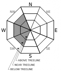
Up to 14 inches of fresh snow sits over a shallow snowpack. Avalanche danger is low. Continue to watch for unstable snow on isolated steep areas that previously held a snowpack. Small, wind slabs may form on SW, W, and NW aspects near and above treeline.


Avalanche Problem 1: Wind Slab
-
Character ?

-
Aspect/Elevation ?
-
Likelihood ?CertainVery LikelyLikelyPossible
 Unlikely
 -
Size ?HistoricVery LargeLargeSmall

LOW avalanche danger exists for all aspects and elevations. Human triggered avalanches are unlikely, but not impossible. Productive winds out of the east could form fresh wind slabs on SW, W, and NW aspects. These will likely remain small. No wind slab formation was observed yesterday. Wind slabs that form in areas that held a deep enough snowpack to provide a bed surface before the Christmas storm are most suspect. These predominantly lie in near treeline terrain.
Identify where wind slabs may exist by paying attention to clues like blowing snow, cornices above a slope, snowdrifts, and wind created surface textures. Shooting cracks, blocking, and hollow sounding snow are signs that wind slabs may be reactive to a human trigger. Adjust travel plans to minimize exposure to potential wind slab avalanches.
Forecast Discussion
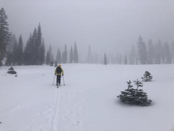
The Mount Shasta Nordic Center opens today. Drive safe. The roads are icy.
Use safe travel techniques and always bring your beacon, shovel, probe and most importantly, know how to use them.
Freshen up your avalanche rescue skills by doing a few drills when you get to the parking lot. Check out this video for a quick explanation of companion rescue:
Recent Observations
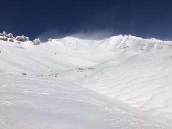
Mount Shasta received 14 inches of new snow (0.96 SWE) on Christmas. This fresh snow sits over a shallow snowpack. Snow depths average 13 to 33 inches across the forecast area. An observation in Avalanche Gulch found smooth snow surfaces with little to no wind effect below 9,000 feet. Small drifts up to two feet deep have formed at upper elevations. A few protected areas near treeline host weak layers of sugary snow mixed with thick crusts in the old snow. The snowpack is still shallow, and many rocks and logs are barely hidden.
In the last 24 hours, winds on Gray Butte have been out of the west averaging 10 mi/hr and maxing out at 19 mi/ hr with gusts to 37 mi/hr. Temperatures have ranged from 16.5 ℉ to 25 ℉.

Weather and Current Conditions
Weather Summary
We will be greeted by partly cloudy skies then sunny conditions today. Winds will be light to moderate out of the east. There is a slight chance at some freezing fog if you are out early this morning. This should burn off before 10 a.m. Expect temperatures to stay cool with highs in the low 30s F. Temperatures at upper elevations will remain in the teens to low 20s.
The models have significantly decreased in precipitation amounts predicted for the next storm now scheduled on Wednesday. Only a few inches of snow is expected. However, this storm sets the stage for a series of promising storms in early January.
24 Hour Weather Station Data @ 6:00 AM
| Weather Station | Temp (°F) | Wind (mi/hr) | Snow (in) | Comments | ||||||||
|---|---|---|---|---|---|---|---|---|---|---|---|---|
| Cur | Min | Max | Avg | Avg | Max Gust | Dir | Depth | New | Water Equivalent | Settlement | ||
| Mt. Shasta City (3540 ft) | 25 | 25 | 42 | 33 | 1 | N | ||||||
| Sand Flat (6750 ft) | 17 | 16 | 29 | 24 | Depth sensor not working. | |||||||
| Ski Bowl (7600 ft) | 20.5 | 17 | 28 | 21.5 | 33.8 | 0 | 0.1 | 1.0 | ||||
| Gray Butte (8000 ft) | 18.5 | 16.5 | 25 | 20.5 | 10 | 37 | WSW | |||||
| Castle Lake (5870 ft) | 24.5 | 23 | 31 | 26.5 | 13.2 | 0 | 0.4 | |||||
| Mount Eddy (6509 ft) | 19 | 15.5 | 29 | 22.5 | 2 | 5 | WSW | 26 | 0 | 0 | ||
| Ash Creek Bowl (7250 ft) | 25.5 | 17.5 | 25.5 | 22 | 30.5 | 1 | 0 | |||||
| Ash Creek Ridge (7895 ft) | 16.5 | 15 | 21.5 | 18.5 | 0 | 0 | N |
Two Day Mountain Weather Forecast
Produced in partnership with the Medford NWS
| For 7000 ft to 9000 ft | |||
|---|---|---|---|
|
Sunday (4 a.m. to 10 p.m.) |
Sunday Night (10 p.m. to 4 a.m.) |
Monday (4 a.m. to 10 p.m.) |
|
| Weather | Partly cloudy this morning, then becoming mostly cloudy. Some patchy freezing fog is possible. | Partly cloudy. | Partly cloudy, becoming sunny. |
| Temperature (°F) | 32 | 18 | 31 |
| Wind (mi/hr) | East 5-10 | East 5-10 | Northeast 5-10 |
| Precipitation SWE / Snowfall (in) | 0.00 / 0 | 0.00 / 0 | 0.00 / 0 |
| For 9000 ft to 11000 ft | |||
| Sunday | Sunday Night | Monday | |
| Weather | Partly cloudy this morning, then becoming mostly sunny. | Partly cloudy. | Partly cloudy, becoming sunny. |
| Temperature (°F) | 21 | 14 | 19 |
| Wind (mi/hr) | South 20-25 | Southeast 15-20 | East 20-25 |
| Precipitation SWE / Snowfall (in) | 0.00 / 0 | 0.00 / 0 | 0.00 / 0 |
Season Precipitation for Mount Shasta City
| Period | Measured (in) | Normal (in) | Percent of Normal (%) |
|---|---|---|---|
| From Oct 1, 2025 (the wet season) | 3.49 | 13.93 | 25 |
| Month to Date (since Jun 1, 2026) | 1.79 | 6.57 | 27 |
| Year to Date (since Jan 1, 2026) | 16.40 | 41.93 | 39 |

