

You are here
Avalanche Forecast for 2021-01-04 06:55
- EXPIRED ON January 5, 2021 @ 6:55 amPublished on January 4, 2021 @ 6:55 am
- Issued by Ryan Sorenson - Mount Shasta Avalanche Center
Bottom Line
Heavy snowfall is expected today. Avalanche danger is elevated. Wind slabs will grow in size, distribution and likelihood of triggering. Human-triggered medium to large-sized wind slab avalanches are likely on wind loaded near and above treeline terrain. Storm slab avalanches are possible on steep slopes below and near treeline. Natural avalanches are possible.


Avalanche Problem 1: Wind Slab
-
Character ?

-
Aspect/Elevation ?
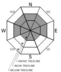
-
Likelihood ?CertainVery LikelyLikelyPossible
 Unlikely
 -
Size ?HistoricVery LargeLargeSmall

Avalanche danger will rise as new snow mixes with strong southwesterly winds today. Models predict up to 16 inches of snow accumulation above 5,100 feet. Wind slabs are expected to develop predominantly on W-NW-N-NE-E aspects. However, terrain features may allow for local variations in wind direction and wind slab development. Wind slabs are expected to grow medium to large in size and are likely to be reactive to human triggering. Natural wind slab avalanches are possible. A few cornices and wind loaded areas were responsive to stomping on small test slopes yesterday.
Avoid traveling near or on steep wind-loaded slopes today. Continue to pay attention to clues like blowing snow, cornices above a slope, snowdrifts, and wind created surface textures. Shooting cracks, blocking, and hollow sounding snow are signs that wind slabs may be nearby.
Avalanche Problem 2: Storm Slab
-
Character ?

-
Aspect/Elevation ?
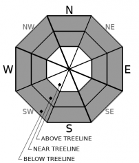
-
Likelihood ?CertainVery LikelyLikelyPossible
Unlikely
-
Size ?HistoricVery LargeLargeSmall
Today's heavy snowfall and changing temperatures will cause a concern for storm slab development on steep slopes below and near treeline. Storm slabs avalanches occur when a cohesive layer of snow releases within the new snow or at the old snow interface. Temperature changes during a storm often create the right conditions for these slabs to form. Avoid this problem by staying away from convex rollovers, unsupported slopes, and slopes over 35 degrees.
Storm slabs tend to have a short life span. They are easiest to trigger during periods of heavy snow and typically stabilize within a day or two after the storm cycle has ended.
Forecast Discussion
The National Weather Service has issued a winter storm warning from 4 a.m. Tuesday above 5,000 feet.
Avalanche danger is elevated today. So if you venture out, keep in mind the 5 red flags indicating avalanche danger:
- Recent avalanche activity
- Cracking, blocking, or whoomphing
- Significant snowfall in 24 hours
- Strong winds
- Rapid warming
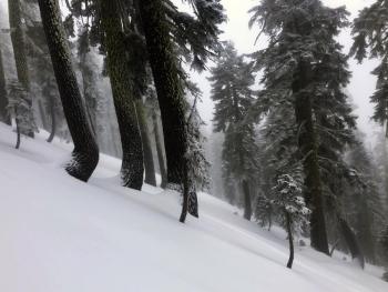
Recent Observations
- Over the last 24 hours, Mount Shasta has received 2 inches of new snow (0.51" snow/water equivalent - SWE) at 7,600 feet.
- Yesterday was overcast, foggy, and misty. Visibility was very low.
- Rain on snow was observed up to 8,200 feet on Green Butte yesterday.
- A thin ice lens has developed on the snow surfaces below and near the treeline throughout the forecast area.
- Temperatures maxed out at 30.5 °F at noon and averaged 27.5 °F over the past 24 hours at 7,600 feet on Mount Shasta.
- Westerly winds have been moderate on Gray Butte. Winds have increased and switched to a more southerly flow over the past two hours (4 a.m. and 5 a.m.).
- The total snow height is 34.2 inches at our Old Ski Bowl weather station on Mount Shasta.
- The Sand Flat winter trails are in good shape.
- Pilgrim Creek snowmobile park is open. The snowpack at the park is thin.
- Castle Lake has 14 inches on the ground.
- The Eddy Mountains have 25-30 inches of snow and better coverage.

Weather and Current Conditions
Weather Summary
This storm has had a sputtery start, but it's running on all cylinders now. Expect cloudy skies, breezy conditions and widespread blowing snow. Snowfall will be heavy at times. Strong winds will be out of the south/southwest. Temperatures will decrease throughout the day, reaching the upper to mid-20s F. There is a winter storm warning in effect until 4 a.m. on Tuesday above 5,000 feet.
We're looking at 1.36 inches of water scheduled to fall between 4 a.m. to 10 p.m. This equates to 8 to 14 inches of snow for lower elevations and up to 16 inches of snow at higher elevations. Snow levels are expected to come down to 5,100 feet. The heaviest snowfall will be this morning, then constant snowfall throughout the day. The storm should begin to clear sometime after 10 p.m.
We will have a short break in the weather tomorrow with partly cloudy skies. Another small storm is scheduled for Wednesday.
24 Hour Weather Station Data @ 6:00 AM
| Weather Station | Temp (°F) | Wind (mi/hr) | Snow (in) | Comments | ||||||||
|---|---|---|---|---|---|---|---|---|---|---|---|---|
| Cur | Min | Max | Avg | Avg | Max Gust | Dir | Depth | New | Water Equivalent | Settlement | ||
| Mt. Shasta City (3540 ft) | 40 | 38 | 43 | 40 | 4 | ESE | ||||||
| Sand Flat (6750 ft) | 30 | 0 | 33 | 29 | Depth sensor not working. | |||||||
| Ski Bowl (7600 ft) | 26.5 | 25.5 | 30.5 | 27.5 | 34.5 | 2.4 | 0.51 | 0 | ||||
| Gray Butte (8000 ft) | 26 | 24 | 29 | 27 | 10 | 37 | W | |||||
| Castle Lake (5870 ft) | 31 | 29.5 | 36 | 32 | 13.8 | 0.6 | 0 | |||||
| Mount Eddy (6509 ft) | 29.5 | 28 | 35 | 31 | 2 | 6 | SW | 30.3 | 1.6 | 0 | ||
| Ash Creek Bowl (7250 ft) | 27.5 | 27 | 30 | 28.5 | 29.8 | 0.3 | 0 | |||||
| Ash Creek Ridge (7895 ft) | 24.5 | 24 | 27.5 | 26 | wind sensor rimed |
Two Day Mountain Weather Forecast
Produced in partnership with the Medford NWS
| For 7000 ft to 9000 ft | |||
|---|---|---|---|
|
Monday (4 a.m. to 10 p.m.) |
Monday Night (10 p.m. to 4 a.m.) |
Tuesday (4 a.m. to 10 p.m.) |
|
| Weather | Snow. Heavy snowfall at times. Cloudy, breezy. Widespread blowing snow. Snow levels near 5,100 feet. | Mostly cloudy with a 50 percent chance of snow showers in the evening, then partly cloudy after midnight. | Partly cloudy in the morning then becoming mostly cloudy. |
| Temperature (°F) | 35 | 22 | 34 |
| Wind (mi/hr) | South 20-25 | West 5-10 | South 5-10 |
| Precipitation SWE / Snowfall (in) | 1.36 / 8-14 | 0.01 / 0-1 | 0.00 / 0 |
| For 9000 ft to 11000 ft | |||
| Monday | Monday Night | Tuesday | |
| Weather | Snow. Heavy snowfall at times. Breezy. Widespread blowing snow. Windy. Wind chill values as low as -13. | Mostly cloudy with a 50 percent chance of snow showers in the evening, then partly cloudy after midnight. | Partly cloudy in the morning then becoming mostly cloudy. |
| Temperature (°F) | 25 | 15 | 26 |
| Wind (mi/hr) | Southwest 50-60 | West 20-25 | West 25-30 |
| Precipitation SWE / Snowfall (in) | 1.36 / 10-16 | 0.01 / 0-1 | 0.00 / 0 |
Season Precipitation for Mount Shasta City
| Period | Measured (in) | Normal (in) | Percent of Normal (%) |
|---|---|---|---|
| From Oct 1, 2025 (the wet season) | 3.73 | 15.92 | 23 |
| Month to Date (since Jun 1, 2026) | 0.15 | 0.71 | 21 |
| Year to Date (since Jan 1, 2026) | 0.15 | 0.71 | 21 |

