

You are here
Avalanche Forecast for 2021-01-09 06:02
- EXPIRED ON January 10, 2021 @ 6:02 amPublished on January 9, 2021 @ 6:02 am
- Issued by Nick Meyers - Shasta-Trinity National Forest
Bottom Line
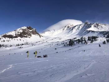
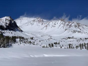
Early yesterday morning brought 5-7 inches of new snow, followed up by a northwest wind event. The overall avalanche danger is LOW, but don't kick caution in the can. Watch for wind slabs in isolated areas and/or in extreme terrain today.


Avalanche Problem 1: Wind Slab
-
Character ?

-
Aspect/Elevation ?
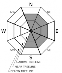
-
Likelihood ?CertainVery LikelyLikelyPossible
 Unlikely
 -
Size ?HistoricVery LargeLargeSmall

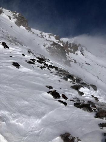
Northwest winds pounded the upper mountain yesterday and moved a lot of snow around...some of it sublimating off the mountain. Mid and lower elevation wind was swirling and funky. It's the second day after a storm/wind event, and we think it's prudent to keep wind slabs on the docket, despite any glaring, unstable observations. Wind blowing snow is one of the five red flags of avalanche danger. Continued, blustery conditions are expected on the upper mountain. Look for wind slabs on leeward NE/E/SE facing slopes. Slabs have been stubborn to unreactive, but can sometimes "pop" without warning. Don't just throw your hoody over your head and trudge up the mountain. Pay attention and look around.
Forecast Discussion
During the ongoing Covid-19 pandemic, continue to follow the latest guidance from local, state, and federal health officials. Avoid unnecessary risks that could impact first responders and stress medical resources. Wear a mask when appropriate, practice social distancing, and consider recreating closer to home.
Recent Observations
You've heard it by now, yesterday was characterized by blue sky and strong northwesterly wind. Incredible plumes of snow could be observed flying horizontal off upper mountain ridge lines. New snow from the quick hitting storm yesterday morning measured 5 to 7 inches with rather uniform cover. Quite a few users laid tracks on the mountain with no alarming wind slab triggers. A little surprising given the amount of wind transport. We are tired of saying this, but rocks hiding underneath a shallow snowpack is still an issue. Check out new observations/photos below.

Weather and Current Conditions
Weather Summary
A mostly sunny day on tap. Northwest wind is likely over higher terrain. Valleys may hold some fog and low clouds. A front moves into the Pacific Northwest tonight, but will mostly fizzle, and we shouldn't expect much out of it. Perhaps a trace of new snow, if anything at all. Sunshine will return Sunday. More winter-like weather is being talked about for next week, but unfortunately no showstoppers.
24 Hour Weather Station Data @ 4:00 AM
| Weather Station | Temp (°F) | Wind (mi/hr) | Snow (in) | Comments | ||||||||
|---|---|---|---|---|---|---|---|---|---|---|---|---|
| Cur | Min | Max | Avg | Avg | Max Gust | Dir | Depth | New | Water Equivalent | Settlement | ||
| Mt. Shasta City (3540 ft) | 23 | 23 | 43 | 32.5 | 1 | N | ||||||
| Sand Flat (6750 ft) | 15 | 14 | 27 | 22 | 0 | 0 | 0 | 0 | Depth sensor not working. | |||
| Ski Bowl (7600 ft) | 23 | 17.5 | 25 | 21.5 | 46.1 | 2.5 | 0.13 | 0 | ||||
| Gray Butte (8000 ft) | 28 | 18.5 | 28 | 21.5 | 10 | 49 | ESE | |||||
| Castle Lake (5870 ft) | 25 | 22.5 | 32 | 26.5 | 24.2 | 0 | 0.3 | |||||
| Mount Eddy (6509 ft) | 20 | 15.5 | 27.5 | 23 | 2 | 6 | WSW | 39.9 | 0.6 | 0 | ||
| Ash Creek Bowl (7250 ft) | 19 | 16.5 | 25.5 | 21 | 37 | 0.7 | 0 | |||||
| Ash Creek Ridge (7895 ft) | 26 | 15.5 | 26 | 18.5 | 11 | 43 | WSW |
Two Day Mountain Weather Forecast
Produced in partnership with the Medford NWS
| For 7000 ft to 9000 ft | |||
|---|---|---|---|
|
Saturday (4 a.m. to 10 p.m.) |
Saturday Night (10 p.m. to 4 a.m.) |
Sunday (4 a.m. to 10 p.m.) |
|
| Weather | Mostly sunny | Partly to mostly cloudy. A 20% chance of showers after midnight. Snow level near 5,400 feet. | Mostly sunny |
| Temperature (°F) | 38 | 30 | 37 |
| Wind (mi/hr) | North/Northwest 5-10 | South/Southeast 5-10 | East/Southeast 0-5 |
| Precipitation SWE / Snowfall (in) | 0.10 / 0 | 0.02 / 0-0.25 | 0.00 / 0 |
| For 9000 ft to 11000 ft | |||
| Saturday | Saturday Night | Sunday | |
| Weather | Mostly sunny, blustery | Mostly cloudy, with a 30% chance of snow between 1 a.m. and 4 a.m. Windy. | Mostly sunny, blustery |
| Temperature (°F) | 28 | 22 | 28 |
| Wind (mi/hr) | North/northwest 10-20 | Southwest 10-20 | Southwest 10-20 |
| Precipitation SWE / Snowfall (in) | 0.10 / 0 | 0.02 / 0-0.50 | 0.00 / 0 |
Season Precipitation for Mount Shasta City
| Period | Measured (in) | Normal (in) | Percent of Normal (%) |
|---|---|---|---|
| From Oct 1, 2025 (the wet season) | 5.54 | 17.10 | 32 |
| Month to Date (since Jun 1, 2026) | 1.96 | 1.89 | 104 |
| Year to Date (since Jan 1, 2026) | 1.96 | 1.89 | 104 |

