

You are here
Avalanche Forecast for 2021-01-10 06:15
- EXPIRED ON January 11, 2021 @ 6:15 amPublished on January 10, 2021 @ 6:15 am
- Issued by Ryan Sorenson - Mount Shasta Avalanche Center
Bottom Line
Warm temperatures and calm winds have settled concerns for avalanche activity. Though unlikely, a small wind slab could linger on steep leeward slopes. Normal caution is advised.


Avalanche Problem 1: Normal Caution
-
Character ?

-
Likelihood ?CertainVery LikelyLikelyPossible
 Unlikely
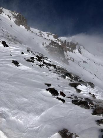
For today, use normal caution. Avalanche danger is low. Keep an eye out for isolated wind slabs lingering on steep leeward terrain. Strong winds previously blew out of the northwest. Expect light winds out of the southwest today. Warming temperatures yesterday have allowed the snowpack to settle. Any remaining instabilities are likely to be stubborn and difficult to trigger.
Use safe travel techniques and bring your beacon, shovel and probe. Keep your avalanche skills sharp by practicing companion rescue and identifying avalanche terrain.
Forecast Discussion
Don't rule out loose wet avalanches if you find yourself on steep southerly aspects late in the day. These start at a point and entrain snow as they move down the hill. If you are sinking up to your ankles in wet snow, avoid steep, sunlit slopes above terrain traps and cliff areas.
During the ongoing Covid-19 pandemic, follow the latest guidance from local, state, and federal health officials. Avoid unnecessary risks that could impact first responders and stress medical resources. Wear a mask when appropriate, practice social distancing, and consider recreating closer to home.
Recent Observations
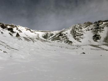
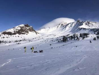
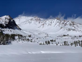
Yesterday morning, strong northwesterly winds kicked in again. A lenticular cloud hung, as visible blowing and sublimating snow disappeared from the upper mountain. Things calmed down and cleared by late morning. Mostly sunny conditions prevailed, and temperatures soared. We noticed rollerballs forming on southerly aspects, and trees began to drip by mid-afternoon. A melt-freeze crust likely formed last night. Protected below and near treeline terrain holds a deeper and softer snowpack. Looking at the upper mountain, it's hard to miss the scoured north and westerly aspect of ridges and moraine tops. There were no obvious signs of avalanche danger or instabilities reported or observed yesterday. We've said it before, but I'll repeat it, many rocks, logs, and bushes remain barely hidden.
Weather and Current Conditions
Weather Summary
We will have another sunny day. There may be a few lingering clouds early this morning, as well as possible valley fog. These will dissipate quickly, leaving mostly clear skies. Upper elevations will have light southwesterly winds. Temperatures are expected to climb into the upper 30's °F for lower elevations and low 30's °F for higher elevations.
On Monday night, we may catch a wisp of a storm passing north of our area. Little is expected until Tuesday when a warm front stalled out in the Pacific moves in. So far, models are showing 0.78 inches of water with snow levels as high as 6,700 feet.
24 Hour Weather Station Data @ 3:00 AM
| Weather Station | Temp (°F) | Wind (mi/hr) | Snow (in) | Comments | ||||||||
|---|---|---|---|---|---|---|---|---|---|---|---|---|
| Cur | Min | Max | Avg | Avg | Max Gust | Dir | Depth | New | Water Equivalent | Settlement | ||
| Mt. Shasta City (3540 ft) | 33 | 23 | 42 | 32 | 2 | N | ||||||
| Sand Flat (6750 ft) | 31 | 15 | 34 | 27 | 0 | 0 | 0 | 0 | Depth sensor not working. | |||
| Ski Bowl (7600 ft) | 31.5 | 23 | 44.5 | 35 | 45 | 0 | 0 | 1.1 | ||||
| Gray Butte (8000 ft) | 31 | 28 | 40.5 | 35 | 10 | 31 | WNW | |||||
| Castle Lake (5870 ft) | 35 | 24.5 | 38 | 33 | 24.4 | 0 | 0 | |||||
| Mount Eddy (6509 ft) | 33 | 20 | 44 | 36 | 2 | 5 | WSW | 38.4 | 0 | 1.5 | ||
| Ash Creek Bowl (7250 ft) | 34.5 | 19 | 39.5 | 33 | 36.2 | 0 | 0.8 | |||||
| Ash Creek Ridge (7895 ft) | 30.5 | 26 | 37.5 | 33 | 9 | 32 | WNW |
Two Day Mountain Weather Forecast
Produced in partnership with the Medford NWS
| For 7000 ft to 9000 ft | |||
|---|---|---|---|
|
Sunday (4 a.m. to 10 p.m.) |
Sunday Night (10 p.m. to 4 a.m.) |
Monday (4 a.m. to 10 p.m.) |
|
| Weather | Mostly sunny | Partly cloudy | Mostly sunny |
| Temperature (°F) | 38 | 28 | 40 |
| Wind (mi/hr) | South 5-10 | South/Southeast 0-5 | South 0-5 |
| Precipitation SWE / Snowfall (in) | 0.00 / 0 | 0.00 / 0 | 0.00 / 0 |
| For 9000 ft to 11000 ft | |||
| Sunday | Sunday Night | Monday | |
| Weather | Mostly sunny | Mostly cloudy | Mostly sunny |
| Temperature (°F) | 30 | 30 | 32 |
| Wind (mi/hr) | Southwest 10-20 | Southwest 10-20 | Southwest 10-20 |
| Precipitation SWE / Snowfall (in) | 0.00 / 0 | 0.00 / 0-0.50 | 0.00 / 0 |
Season Precipitation for Mount Shasta City
| Period | Measured (in) | Normal (in) | Percent of Normal (%) |
|---|---|---|---|
| From Oct 1, 2025 (the wet season) | 5.54 | 17.35 | 32 |
| Month to Date (since Jun 1, 2026) | 1.96 | 2.14 | 92 |
| Year to Date (since Jan 1, 2026) | 1.96 | 2.14 | 92 |

