

You are here
Avalanche Forecast for 2021-01-11 06:15
- EXPIRED ON January 12, 2021 @ 6:15 amPublished on January 11, 2021 @ 6:15 am
- Issued by Ryan Sorenson - Mount Shasta Avalanche Center
Bottom Line
Warm temperatures have made the possibility of triggering an avalanche increasingly unlikely. Our snowpack is thin. Many hidden and not so hidden obstacles remain. Normal caution is advised. Anticipate changing conditions. A storm front is expected late tonight.


Avalanche Problem 1: Normal Caution
-
Character ?

-
Likelihood ?CertainVery LikelyLikelyPossible
 Unlikely
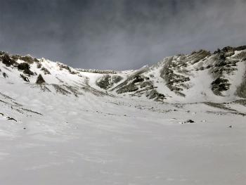
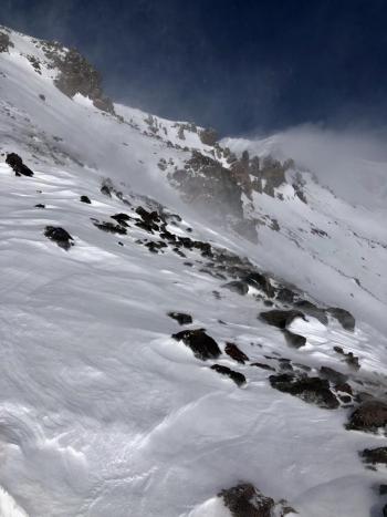
Avalanche danger is low. Continue to keep an eye out for isolated wind slabs lingering on steep leeward terrain. Strong winds previously blew out of the northwest. Variable winds were observed yesterday. Any remaining instabilities are likely to be small, stubborn, and difficult to trigger.
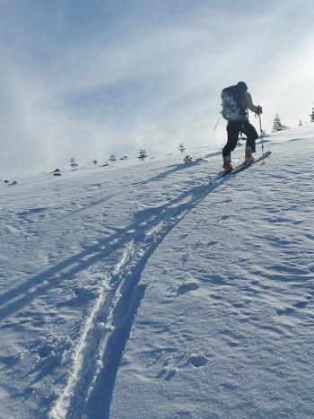
Keep your avalanche skills sharp by practicing companion rescue and identifying avalanche terrain. Be aware of how your decisions impact you and your group as you travel in and near avalanche terrain. Always use safe travel techniques and bring your beacon, shovel and probe.
Recent Observations
- Over the last 24 hours, Mount Shasta has received 0.5 to 1 inch of new snow (0.02" snow/water equivalent - SWE) at 7,600 feet.
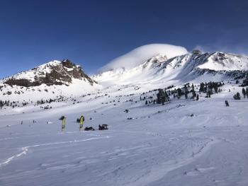
- Yesterday was mostly clear with valley fog. Fog layers varied from 6,000 to 7,000 feet, tops and bottoms around 5,000 feet.
- New snow sits over variable snow surfaces. Snow surfaces include breakable melt-freeze crusts, icy patches, and chalky wind pressed sastrugi. Softer snow surfaces can be found in gullies and below treeline.
- Windward SW/W/NW ridges and moraines are scoured, rocky, and the snow is thin.
- A deeper snowpack remains below and near the treeline.
- Temperatures maxed out at 40 °F at 5 a.m. this morning and averaged 32.5 °F over the past 24 hours at 7,600 feet on Mount Shasta.
- Winds have been light to moderate and variable in direction. Winds have increased and switched to northwesterly this morning.
- The total snow height is 44.4 inches at our Old Ski Bowl weather station on Mount Shasta.
- The total snow height at our Mount Eddy Station is 37.4 inches. Castle Lake has 23.6 inches on the ground, and Ashcreek Butte has 35.6 inches.
Weather and Current Conditions
Weather Summary
Similar to yesterday, upper elevation skies will clear to mostly sunny conditions. There may be a few lingering clouds early this morning. Valley fog is likely though the chances are good that it will dissipate before noon. This will leave room for a storm front scheduled to push in late tonight. Temperatures will be slightly elevated compared to yesterday, climbing into the upper 30's °F for lower elevations and low 30's °F for higher elevations. Upper elevations will have light to moderate southwesterly winds.
The warm front stalled out in the Pacific will move in late tonight or early tomorrow morning. Models show 0.78 inches of water with snow levels near 6,000 feet between 10 p.m. and 4 a.m. Wednesday. Total snow accumulation of 3 to 7 inches of snow for lower elevations and 5 to 10 inches for upper elevations is expected.
24 Hour Weather Station Data @ 6:00 AM
| Weather Station | Temp (°F) | Wind (mi/hr) | Snow (in) | Comments | ||||||||
|---|---|---|---|---|---|---|---|---|---|---|---|---|
| Cur | Min | Max | Avg | Avg | Max Gust | Dir | Depth | New | Water Equivalent | Settlement | ||
| Mt. Shasta City (3540 ft) | 33 | 23 | 42 | 32 | 2 | N | ||||||
| Sand Flat (6750 ft) | 31 | 15 | 34 | 27 | 0 | 0 | 0 | 0 | Depth sensor not working. | |||
| Ski Bowl (7600 ft) | 37 | 28 | 37.5 | 32 | 44.3 | 0 | 0.00 | 0.7 | ||||
| Gray Butte (8000 ft) | 37 | 27 | 38 | 31.5 | 8 | 37 | WNW | |||||
| Castle Lake (5870 ft) | 32.5 | 29 | 39 | 33 | 23.5 | 0 | 0.9 | |||||
| Mount Eddy (6509 ft) | 35 | 28 | 37.5 | 32.5 | 2 | 4 | WSW | 37.2 | 0. | 1.2 | ||
| Ash Creek Bowl (7250 ft) | 34 | 28 | 34.5 | 31 | 35.8 | 0 | 0.3 | |||||
| Ash Creek Ridge (7895 ft) | 36.5 | 26 | 37.5 | 30.5 | 5 | 30 | W |
Two Day Mountain Weather Forecast
Produced in partnership with the Medford NWS
| For 7000 ft to 9000 ft | |||
|---|---|---|---|
|
Monday (4 a.m. to 10 p.m.) |
Monday Night (10 p.m. to 4 a.m.) |
Tuesday (4 a.m. to 10 p.m.) |
|
| Weather | Mostly sunny | Mostly cloudy. Windy. Chance of rain and snow after 10 p.m. Snow levels near 6,000 feet. | Windy. Rain and snow showers. Snow levels near 6,400 feet. |
| Temperature (°F) | 38 | 32 | 35 |
| Wind (mi/hr) | South 5-10 | South 10-15 | South 15-25 |
| Precipitation SWE / Snowfall (in) | 0.00 / 0 | 0.03 / 0-1 | 0.60 / 2-6 |
| For 9000 ft to 11000 ft | |||
| Monday | Monday Night | Tuesday | |
| Weather | Mostly sunny | Mostly cloudy. Windy. Chance of snow after 10 p.m. Chance of precipitation is 60%. | Snow showers. Windy. |
| Temperature (°F) | 32 | 27 | 31 |
| Wind (mi/hr) | Southwest 15-20 | Southwest 35-40 | South 45-55 |
| Precipitation SWE / Snowfall (in) | 0.00 / 0 | 0.03 / 0-1 | 0.60 / 4-8 |
Season Precipitation for Mount Shasta City
| Period | Measured (in) | Normal (in) | Percent of Normal (%) |
|---|---|---|---|
| From Oct 1, 2025 (the wet season) | 5.54 | 17.60 | 31 |
| Month to Date (since Jun 1, 2026) | 1.96 | 2.39 | 82 |
| Year to Date (since Jan 1, 2026) | 1.96 | 2.39 | 82 |

