

You are here
Avalanche Forecast for 2021-01-12 06:30
- EXPIRED ON January 13, 2021 @ 6:30 amPublished on January 12, 2021 @ 6:30 am
- Issued by Ryan Sorenson - Mount Shasta Avalanche Center
Bottom Line
A warm storm will bring rain and heavy, wet snow to the mountains over the next 48 hours. Snow levels near 6,700 feet are expected to rise as high as 8,300 feet. Avalanche danger will increase to MODERATE at upper elevations today as fresh snow combines with productive south/southwest wind. Human triggered wind slab avalanches are possible on steep leeward slopes above treeline.


Avalanche Problem 1: Wind Slab
-
Character ?

-
Aspect/Elevation ?
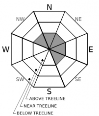
-
Likelihood ?CertainVery LikelyLikelyPossible
 Unlikely
 -
Size ?HistoricVery LargeLargeSmall

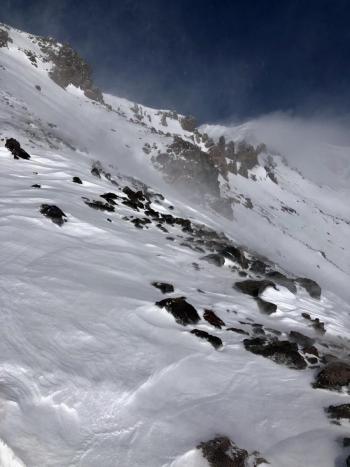
Fresh snow above 6,700 feet will mix with productive south/southwesterly winds today. Snow accumulation of 3 to 5 inches is possible above treeline. Watch for fresh wind slab development on NW-N-NE-E-SE aspects at higher elevations. Wind slabs are expected to be small to medium-sized and could be reactive to human triggering. Warm temperatures before this storm have settled the concern of any lingering instabilities in the snowpack.
Stay mindful as you travel in the backcountry. Ask yourself where wind slabs might be forming. Pay attention to areas that you find smooth, rounded, hollow-sounding pillows of snow. Use small test slopes out of avalanche terrain to stomp around on and look for cracking and blocking within the snowpack. Adjust travel plans to minimize exposure to wind slabs on steep slopes.
Forecast Discussion
With rain on snow, it's always good to think of loose wet avalanches. These usually start at a point and entrain snow as they move down the hill. We don't anticipate this to be of concern today given the amount of water predicted. However, if you are sinking up to your knees in wet snow, it's best to avoid steep slopes above terrain traps and cliff areas.
Recent Observations
Yesterday was mostly clear and warm. We toured over in the Trout Creek drainage to observe the colder fringe regions of our forecast area. North facing aspects still host low-density snow, but warm temperatures were causing dripping trees and pinwheels in sun-exposed areas. Easterly ridges host small cornice formations from previous westerly winds. Five feet of snow was measured in a pit dug near treeline. Click here to read the full observation.
- Over the last 24 hours, temperatures have ranged from 28.5 °F to 44 °F at 7,600 feet on Mount Shasta.
- The total snow depth is 43.4 inches at our Old Ski Bowl weather station.
- Snow surfaces are variable. They include breakable melt-freeze crusts, icy patches, and chalky wind pressed sastrugi. Softer snow surfaces exist in gullies and below treeline.
- A deeper snowpack remains in protected areas below and near treeline.
- Windward SW/W/NW ridges and moraines are scoured and rocky and snow is thin.
- Winds have been light to moderate out of the west/northwest.
Weather and Current Conditions
Weather Summary
A warm storm will begin to bring heavy, wet snow and rain to the Mount Shasta area this morning. Snow levels are predicted at 6,700 ft today and will rise this evening and tomorrow. The chances are good that we will see rain up to 8,200 feet tonight and 8,300 feet tomorrow. Models show 1.11 inches of total water in this storm. The 2 to 4 inches of snow received today at lower elevations will likely get rained on this evening. Higher elevations are expected to accumulate 3 to 5 inches of snow, then an additional 1 to 4 inches tonight and tomorrow.
24 Hour Weather Station Data @ 4:00 AM
| Weather Station | Temp (°F) | Wind (mi/hr) | Snow (in) | Comments | ||||||||
|---|---|---|---|---|---|---|---|---|---|---|---|---|
| Cur | Min | Max | Avg | Avg | Max Gust | Dir | Depth | New | Water Equivalent | Settlement | ||
| Mt. Shasta City (3540 ft) | 42 | 27 | 51 | 39 | 2 | N | ||||||
| Sand Flat (6750 ft) | 32 | 24 | 37 | 32 | Depth sensor not working. | |||||||
| Ski Bowl (7600 ft) | 29 | 28.5 | 44 | 36 | 43.4 | 0 | 0 | 0 | ||||
| Gray Butte (8000 ft) | 28.5 | 26.5 | 41.5 | 34.5 | 14 | 43 | W | |||||
| Castle Lake (5870 ft) | 31.5 | 31.5 | 42 | 36.5 | 23 | 0 | 0.9 | |||||
| Mount Eddy (6509 ft) | 29 | 29 | 48 | 37.5 | 2 | 5 | SSE | 37.3 | 0 | 0.2 | ||
| Ash Creek Bowl (7250 ft) | 30 | 29.5 | 42.5 | 36 | 34.7 | 0 | 1.3 | |||||
| Ash Creek Ridge (7895 ft) | 29 | 26 | 39 | 34 | 20 | 53 | S |
Two Day Mountain Weather Forecast
Produced in partnership with the Medford NWS
| For 7000 ft to 9000 ft | |||
|---|---|---|---|
|
Tuesday (4 a.m. to 10 p.m.) |
Tuesday Night (10 p.m. to 4 a.m.) |
Wednesday (4 a.m. to 10 p.m.) |
|
| Weather | Windy. Rain and snow showers. Snow levels near 6,700 feet. | Windy. Rain and snow showers. Snow levels near 8,200 feet. | Windy. Rain and snow showers in the morning, then a chance of rain in the afternoon. Snow levels near 8,300 feet. |
| Temperature (°F) | 36 | 32 | 39 |
| Wind (mi/hr) | South 15-20 | South 20-25 | Southwest 15-20 |
| Precipitation SWE / Snowfall (in) | 0.58 / 2-4 | 0.15 / 0-1 | 0.35 / 0-2 |
| For 9000 ft to 11000 ft | |||
| Tuesday | Tuesday Night | Wednesday | |
| Weather | Snow showers. Windy. | Mostly cloudy. Windy. Snow showers. | Windy. Snow showers in the morning, then a chance of snow in the afternoon. |
| Temperature (°F) | 32 | 27 | 32 |
| Wind (mi/hr) | Southwest 45-55 | West 50-60 | West 50-60 |
| Precipitation SWE / Snowfall (in) | 0.58 / 3-5 | 0.15 / 0-1 | 0.35 / 1-4 |
Season Precipitation for Mount Shasta City
| Period | Measured (in) | Normal (in) | Percent of Normal (%) |
|---|---|---|---|
| From Oct 1, 2025 (the wet season) | 5.54 | 17.85 | 31 |
| Month to Date (since Jun 1, 2026) | 1.96 | 2.64 | 74 |
| Year to Date (since Jan 1, 2026) | 1.96 | 2.64 | 74 |

