

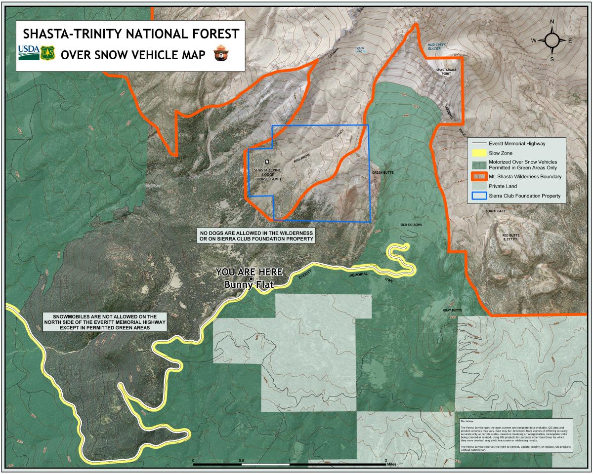
You are here
Avalanche Forecast for 2021-01-31 06:59
- EXPIRED ON February 1, 2021 @ 6:59 amPublished on January 31, 2021 @ 6:59 am
- Issued by Ryan Sorenson - Mount Shasta Avalanche Center
Bottom Line
Avalanche danger is CONSIDERABLE. Over two feet of snow fell this past week. Freezing fog yesterday formed zipper thin ice lenses atop old snow surfaces. Expect a foot of fresh snow over the next 24 hours. Wind slabs will grow in size and distribution with more snow and wind. Storm slabs avalanches are likely on steep terrain below and near treeline. Human and machine triggered avalanches are likely.


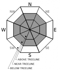
Avalanche Problem 1: Wind Slab
-
Character ?

-
Aspect/Elevation ?
-
Likelihood ?CertainVery LikelyLikelyPossible
 Unlikely
 -
Size ?HistoricVery LargeLargeSmall

We observed moderate south winds atop Gray Butte yesterday. Warmer temperatures, wetter heavy snow, and stronger winds today could allow wind slabs to become reactive on steep leeward terrain. Smaller wind slab avalanches could gouge down to deeper layers as well. While freezing fog and rime ice has caped off much of the preexisting snowpack and likely destroyed most of the surface hoar layers, plenty of soft snow may be available for wind transport above treeline and with the new snow. Areas above treeline, where a thinner ice lense could exist, are most suspect for large wind slab avalanches. Low visibility has limited observations above treeline. Large, fragile cornices along steep ridgelines have also been observed near treeline.
Careful snowpack evaluation, cautious route-finding and conservative decision-making are necessary to avoid wind slab avalanches today. Be willing to step back into safer terrain if you experience cracking and blocking within the snowpack. Adjust travel plans to minimize exposure to wind slabs on steep slopes.
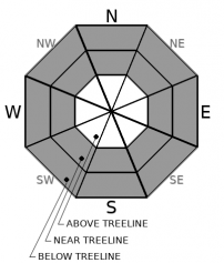
Avalanche Problem 2: Storm Slab
-
Character ?

-
Aspect/Elevation ?
-
Likelihood ?CertainVery LikelyLikelyPossible
Unlikely
-
Size ?HistoricVery LargeLargeSmall
Models predict up to a foot of fresh snow to fall over the next 24 hours. Fluctuating temperatures and snowfall rates are also expected. Such fluctuations are prime for storm slab formation. Much like an upside-down cake, layers of heavier snow may fall atop lighter snow creating a slab within the storm snow. The zipper thin ice lenses from yesterday could provide an ideal bed surface for storm slabs to run on. Storm slabs will be sensitive to trigger on steep slopes and any aspect below and near treeline as we receive more snow.
Forecast Discussion
- The Everitt Memorial Highway and Castle Lake road remain closed.
- Snowmobiles have been launching from McBride Springs and riding up on the mountain in many prohibited areas for motorized equipment. This behavior is not tolerated. See the map below for a reminder of the boundaries.
Recent Observations
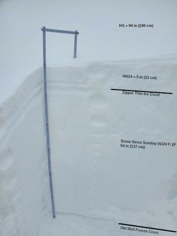
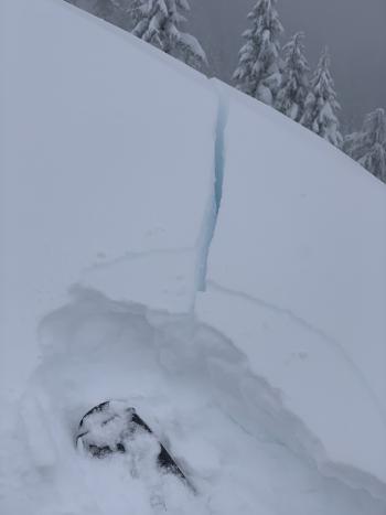
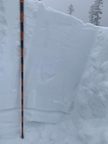
We had a day full of freezing fog and rime on Mount Shasta yesterday. Visibility was low. A zipper thin sheet of rime ice coated everything in sight and as high as 8,100 feet on Gray Butte. This rime likely destroyed the widespread surface hoar we observed on Friday. There was a report of the tailings seen of a large avalanche in Avalanche Gulch above lake Helen which likely released sometime before Wednesday. Little evidence remains. We observed no signs of instability yesterday on Mount Shasta, and reports indicate similar conditions in the Eddies. That said, a few notes:
- We've received over 2 feet of storm snow with low snow levels since Tuesday, January 26th.
- Temperatures on Mount Shasta have varied from 7 ℉ to 26 ℉ near treeline in the last week.
- We've seen several inches of settlement in the snowpack, but several feet of layered snow remains under a zipper thin ice layer.
- It is unknown how prevalent the ice lense is around the area.
- 24-hour total precipitation measured at treeline on Mount Shasta, as of this morning at 0500: 0.4 inches snow / 0.18 SWE (Snow-Water Equivalent)
- Gray Butte wind: light south/southeast wind 5 to 11 mph. Wind gusts as high as 25 mph.
- Total snow heights:
- 71.4 inches (181 cm) - 7,600 feet, Old Ski Bowl
- 60 inches (152cm) - 6,600 feet Mt. Eddy
- 55.1 inches (139 cm) - 5,800 feet, Castle Lake
- 55.1 inches (139 cm) - 7,300 feet, Ash Creek Butte
Weather and Current Conditions
Weather Summary
Expect another round of stormy weather today. Moderate to heavy snowfall will mix with strong southerly winds and an up sloping flow through Tuesday morning. We should see 5 to 10 inches of snow accumulation today, with the heaviest snowfall arriving early this morning. Snow levels may fluctuate between 3,500 and 4,500 feet throughout the day. We will have a brief break in the action tonight with partly cloudy skies and 1-2 inches of snow possible. Another bump of precipitation is expected early Monday morning through Tuesday, with snow levels near 3,500 feet. The higher mountains should easily get another 1-3 feet by Tuesday morning. Cooler air will push in midweek, and we will transition to a northerly flow aloft and mainly dry conditions until Thursday night/Friday morning.
The NWS has issued multiple hazard warnings. Click each for details. Winter Storm Warning / Winter Weather Advisory / Winter Storm Watch
24 Hour Weather Station Data @ 5:00 AM
| Weather Station | Temp (°F) | Wind (mi/hr) | Snow (in) | Comments | ||||||||
|---|---|---|---|---|---|---|---|---|---|---|---|---|
| Cur | Min | Max | Avg | Avg | Max Gust | Dir | Depth | New | Water Equivalent | Settlement | ||
| Mt. Shasta City (3540 ft) | 34 | 33 | 37 | 34 | 3 | SE | ||||||
| Sand Flat (6750 ft) | 25 | 23 | 26 | 25 | 0 | 0 | 0 | 1 | snow sensor broken | |||
| Ski Bowl (7600 ft) | 21.5 | 19 | 23 | 21 | 71.6 | 0 | 0.21 | 1.3 | ||||
| Gray Butte (8000 ft) | 20.5 | 17.5 | 23 | 20 | 7 | 25 | SSE | |||||
| Castle Lake (5870 ft) | 27 | 24 | 28.5 | 26 | 55.1 | 0.8 | 0 | |||||
| Mount Eddy (6509 ft) | 26 | 22.5 | 26 | 24 | 2 | 5 | SSW | 60.5 | 0 | 0.3 | ||
| Ash Creek Bowl (7250 ft) | 22.5 | 20 | 23.5 | 21.5 | 55.1 | 0 | 0.5 | |||||
| Ash Creek Ridge (7895 ft) | 19 | 11.5 | 19 | 16.5 | wind sensor now rimed |
Two Day Mountain Weather Forecast
Produced in partnership with the Medford NWS
| For 7000 ft to 9000 ft | |||
|---|---|---|---|
|
Sunday (4 a.m. to 10 p.m.) |
Sunday Night (10 p.m. to 4 a.m.) |
Monday (4 a.m. to 10 p.m.) |
|
| Weather | Snow, windy. Snow level near 3,800 feet. | Windy. Mostly Cloudy. Snow level near 4,000 feet. | Snow, windy, snow level near 3,800 feet. |
| Temperature (°F) | 30 | 28 | 30 |
| Wind (mi/hr) | South 20-25 | South 20-25 | South 25-30 |
| Precipitation SWE / Snowfall (in) | 0.83 / 5-9 | 0.10 / 0-1 | 1.31 / 8-12 |
| For 9000 ft to 11000 ft | |||
| Sunday | Sunday Night | Monday | |
| Weather | Snow, windy. | Chance of snow, cloudy, windy. | Snow, heavy at times, windy. |
| Temperature (°F) | 23 | 22 | 23 |
| Wind (mi/hr) | South 50-60 | South 50-60 | South 60-70 |
| Precipitation SWE / Snowfall (in) | 0.83 / 6-10 | 0.10 / 1-2 | 1.31 / 9-13 |
Season Precipitation for Mount Shasta City
| Period | Measured (in) | Normal (in) | Percent of Normal (%) |
|---|---|---|---|
| From Oct 1, 2025 (the wet season) | 10.74 | 22.06 | 49 |
| Month to Date (since Jun 1, 2026) | 7.16 | 6.85 | 105 |
| Year to Date (since Jan 1, 2026) | 7.16 | 6.85 | 105 |

