

You are here
Avalanche Forecast for 2021-02-03 06:45
- EXPIRED ON February 4, 2021 @ 6:45 amPublished on February 3, 2021 @ 6:45 am
- Issued by Aaron Beverly - Mount Shasta Avalanche Center
Bottom Line
Avalanche danger is moderate. Human triggered avalanches are possible near and above treeline. The storm is breaking. Two to four inches of snow may fall this morning, but expect clearer, drier, sunnier weather for the next several days.


Avalanche Problem 1: Wind Slab
-
Character ?

-
Aspect/Elevation ?
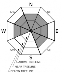
-
Likelihood ?CertainVery LikelyLikelyPossible
 Unlikely
 -
Size ?HistoricVery LargeLargeSmall

As you transition from near treeline to above treeline regions, be cautious around leeward terrain. Cornice breaks and small wind slab avalanches were seen yesterday along steep, north facing ridgelines. There is still some snow available for transport and a few more inches on the way. Slabs could continue to build. Human triggered avalanches are possible.
It is sometimes difficult to determine near treeline terrain from above treeline terrain. The main concern is above treeline, but pay attention as you ascend, as conditions get colder, and as snow becomes lighter. There may be isolated areas in near treeline regions where wind slabs have formed.
Forecast Discussion
Below and near treeline areas could present knee-wrenching ski conditions. A range of wet snow, breakable rain crusts, dust-on-crust, and sloughy conditions may be encountered as you ascend into the alpine.
- The Everitt Memorial Highway and Castle Lake road remain closed. Everitt is expected to open Friday.
- Snowmobiles have been launching from McBride Springs and riding up on the mountain in many prohibited motorized equipment areas. This behavior is not tolerated. See the map for a reminder of the boundaries.
Recent Observations
Forecasted snow totals did not seem to materialize over the last 24 hours. About an inch of snow fell at the Old Ski Bowl weather station. Snow settled 2 inches. Temperatures averaged 21 ºF. West/northwest winds were mostly moderate, averaging 18 mi/hr and gusting up to 55.
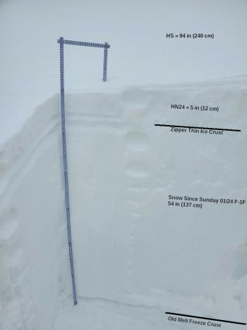
Over the last 3 days, the Old Ski Bowl has received about 8 inches of new snow, most of which occurred during near freezing temperatures, meaning that the snow was moist as it fell. Temperatures have since dropped to a low of 12 deg F, no doubt locking up that moist snow.
The snow from last week's storm has settled, has a right-side-up configuration and is well bonded to the pre-01/26/21 melt-freeze crust.
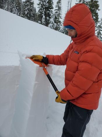
Wet snow and rain-runneled, breakable crusts dominated snow surfaces yesterday on a tour up to Gray Rock Lakes to do a snow survey. Above 6,000 ft, the snowpack firmed up and had about an inch of light snow on top. Some large cornices had formed along north facing ridgelines. A couple of small D1 wind slab avalanches had occurred, probably triggered by cornice breaks.

Weather and Current Conditions
Weather Summary
Expect low snow levels, cold temperatures, and up to 4 inches of snow this morning as a front passes through the area. Moderate to strong west/southwest winds will become northwesterly. After 10 a.m., the weather will begin to settle.
Thursday through Sunday, clearer, mostly sunny conditions will prevail.
24 Hour Weather Station Data @ 5:00 AM
| Weather Station | Temp (°F) | Wind (mi/hr) | Snow (in) | Comments | ||||||||
|---|---|---|---|---|---|---|---|---|---|---|---|---|
| Cur | Min | Max | Avg | Avg | Max Gust | Dir | Depth | New | Water Equivalent | Settlement | ||
| Mt. Shasta City (3540 ft) | 32 | 29 | 43 | 36 | 1 | N | ||||||
| Sand Flat (6750 ft) | 19 | 16 | 32 | 25 | snow sensor broken | |||||||
| Ski Bowl (7600 ft) | 15 | 12.5 | 28 | 20 | 77.3 | 0 | 0.08 | 1.7 | ||||
| Gray Butte (8000 ft) | 14 | 11.5 | 27 | 19.5 | 17 | 55 | WNW | |||||
| Castle Lake (5870 ft) | 20.5 | 20.5 | 34.5 | 27 | 63.1 | 0 | 4.3 | |||||
| Mount Eddy (6509 ft) | 19 | 15.5 | 31 | 23 | 1 | 5 | SE | 66.7 | 0 | 0.6 | ||
| Ash Creek Bowl (7250 ft) | not responding | |||||||||||
| Ash Creek Ridge (7895 ft) | not responding |
Two Day Mountain Weather Forecast
Produced in partnership with the Medford NWS
| For 7000 ft to 9000 ft | |||
|---|---|---|---|
|
Wednesday (4 a.m. to 10 p.m.) |
Wednesday Night (10 p.m. to 4 a.m.) |
Thursday (4 a.m. to 10 p.m.) |
|
| Weather | Snow, mainly before 10 a.m. | Mostly clear. | Sunny. |
| Temperature (°F) | 24 | 20 | 34 |
| Wind (mi/hr) | South 10-15 | North 5-10 | North 5-10 |
| Precipitation SWE / Snowfall (in) | 0.26 / 2-4 | 0.00 / 0 | 0.00 / 0 |
| For 9000 ft to 11000 ft | |||
| Wednesday | Wednesday Night | Thursday | |
| Weather | Snow. Windy. Low wind chills. | Mostly clear. Windy. Low wind chills. | Sunny. Windy. Low wind chills. |
| Temperature (°F) | 19 | 18 | 33 |
| Wind (mi/hr) | West/southwest 30-40 | North 50-60 | North 20-25 |
| Precipitation SWE / Snowfall (in) | 0.26 / 3-5 | 0.00 / 0 | 0.00 / 0 |
Season Precipitation for Mount Shasta City
| Period | Measured (in) | Normal (in) | Percent of Normal (%) |
|---|---|---|---|
| From Oct 1, 2025 (the wet season) | 12.48 | 22.75 | 55 |
| Month to Date (since Jun 1, 2026) | 1.04 | 0.48 | 217 |
| Year to Date (since Jan 1, 2026) | 8.90 | 7.54 | 118 |

