

You are here
Avalanche Forecast for 2021-02-19 06:12
- EXPIRED ON February 20, 2021 @ 6:12 amPublished on February 19, 2021 @ 6:12 am
- Issued by Nick Meyers - Shasta-Trinity National Forest
Bottom Line
Touchy wind slabs remain a concern near and above treeline. A couple additional inches of fresh snow and wind blowing from the left-hand side of the compass is in the forecast. Human triggered avalanches are likely in steep, wind loaded terrain. Pay attention to changing conditions as you travel from trailheads into the alpine.


Avalanche Problem 1: Wind Slab
-
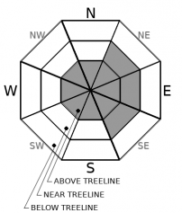
Character ?

-
Aspect/Elevation ?
-
Likelihood ?CertainVery LikelyLikelyPossible
 Unlikely
 -
Size ?HistoricVery LargeLargeSmall

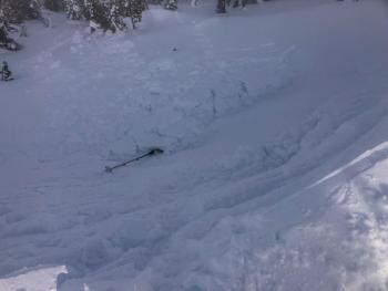
Over the past 24 hours, the wind has shifted around the left-hand side of the compass, blowing NW, WNW, W and SW. More moderate and spatially variable wind was observed yesterday. Where wind was present, wind slabs and cornices were touchy. With new snow and continued wind in the forecast today, I'd expect a similar situation out there. Today's travel plans should account for wind slabs and cornices above a slope. Those steep, leeward NE, E, SE facing slopes will be most suspect, but keep an eye out for strange loading patterns as is common on Mt. Shasta.
Forecast Discussion
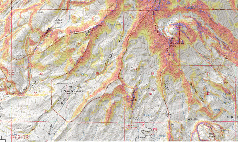
Learning how to recognize avalanche terrain is one of the most important skills to learn. It's all about slope steepness. Any snow covered slope that is 30-45 degrees is considered avalanche terrain. The slope shaded map below is useful in looking at avalanche terrain accessible from one of our most popular trailheads, Bunny Flat. Any terrain that is orange to red color is 30-45 degrees. Download an inclinometer on your phone and learn to measure slope angle.
Recent Observations
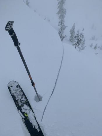
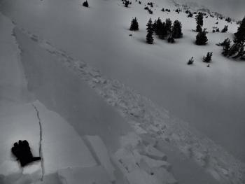
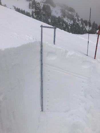
A fast moving winter storm swept through the area yesterday morning, kicking in about daylight and bringing an initial burst of 1-3" of snow at Bunny Flat and 4-6" in the Old Ski Bowl area. Snow was on again, off again during the day. The sky remained obscured. Blue sky and sunshine did not come out to play. The wind was apparent near and above treeline, but spatially variable. One area you'd feel it, not far away you wouldn't. West/Northwest wind speeds overall were diminished and more moderate wind provided for good wind loading on northeast, east, southeast aspects, where wind was present. Temps reached 29.5 F at 1400 hours near treeline. Triggering small wind slabs on test slopes was easy and cracking in the snowpack was observed. Cornices were fragile. Wind slabs were 5-7 inches thick and consisted of the new storm snow and subsequent loading by WNW wind. Below treeline, extended column tests could easily fracture soft slabs within small amount of new snow, but did not propagate.
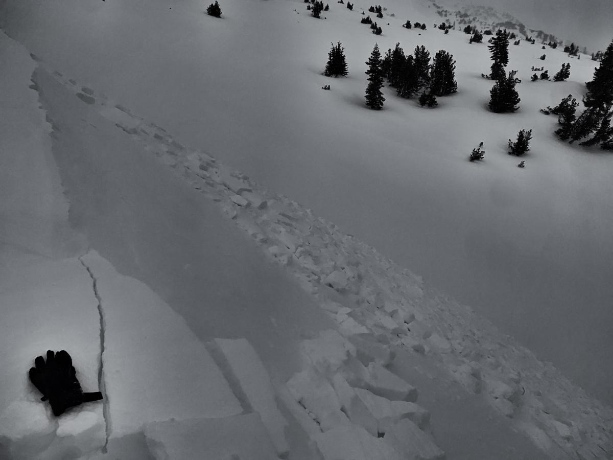
East aspect, above treeline, color enhanced due to flat light.
Weather and Current Conditions
Weather Summary
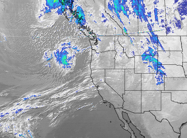
The skies will remain mostly cloudy today with a few snow flurries. Later this evening and tonight, another couple inches will fall. Overall, precipitation will diminish into the weekend. Exposed terrain will experience moderate to strong wind out of the SW/W. We will go back into northwest flow next week with dry conditions through Wednesday. Next best chance of moisture: Thursday.
24 Hour Weather Station Data @ 4:00 AM
| Weather Station | Temp (°F) | Wind (mi/hr) | Snow (in) | Comments | ||||||||
|---|---|---|---|---|---|---|---|---|---|---|---|---|
| Cur | Min | Max | Avg | Avg | Max Gust | Dir | Depth | New | Water Equivalent | Settlement | ||
| Mt. Shasta City (3540 ft) | 32 | 30 | 35 | 33 | 3 | N | ||||||
| Sand Flat (6750 ft) | 25 | 23 | 33 | 27 | n/a | |||||||
| Ski Bowl (7600 ft) | 22 | 19.5 | 36 | 25 | 82.7 | 5.6 | 0.76 | 0 | ||||
| Gray Butte (8000 ft) | 20.5 | 18.5 | 33.5 | 24 | 14 | 37 | W | |||||
| Castle Lake (5870 ft) | 26 | 24 | 36.5 | 28.5 | 64.3 | 1.9 | 0 | |||||
| Mount Eddy (6509 ft) | 25.5 | 21.5 | 37 | 28.5 | 2 | 6 | ESE | 59.8 | 0 | 0.6 | ||
| Ash Creek Bowl (7250 ft) | 23.5 | 22 | 31 | 26 | 59.6 | 1.4 | 0 | |||||
| Ash Creek Ridge (7895 ft) | 20.5 | 18 | 31 | 23.5 | rime |
Two Day Mountain Weather Forecast
Produced in partnership with the Medford NWS
| For 7000 ft to 9000 ft | |||
|---|---|---|---|
|
Friday (4 a.m. to 10 p.m.) |
Friday Night (10 p.m. to 4 a.m.) |
Saturday (4 a.m. to 10 p.m.) |
|
| Weather | Mostly cloudy, snow showers. Snow level near 4,300 feet. | Snow showers, snow level near town. | Mostly cloudy in the morning, then becoming partly cloudy. Slight chance of snow showers in the AM. Snow level near town. |
| Temperature (°F) | 29 | 20 | 30 |
| Wind (mi/hr) | Southwest 5-10 | Southwest 5-10 | Northwest 0-5 |
| Precipitation SWE / Snowfall (in) | 0.04 / 0-1 | 0.10 / 1-2 | 0.00 / 0 |
| For 9000 ft to 11000 ft | |||
| Friday | Friday Night | Saturday | |
| Weather | Snow showers, mostly cloudy, windy. | Snow showers, mostly cloudy, windy. | Chance of snow showers in the AM, then becoming mostly sunny and windy. |
| Temperature (°F) | 18 | 6 | 18 |
| Wind (mi/hr) | West 25-35 | Southwest 20-30 | Northwest 10-20 |
| Precipitation SWE / Snowfall (in) | 0.04 / 0-1 | 0.10 / 1-3 | 0.00 / 0-0.50 |
Season Precipitation for Mount Shasta City
| Period | Measured (in) | Normal (in) | Percent of Normal (%) |
|---|---|---|---|
| From Oct 1, 2025 (the wet season) | 13.55 | 26.77 | 51 |
| Month to Date (since Jul 1, 2026) | 2.11 | 4.50 | 47 |
| Year to Date (since Jan 1, 2026) | 9.97 | 11.56 | 86 |

