

You are here
Avalanche Forecast for 2021-02-25 05:15
- EXPIRED ON February 26, 2021 @ 5:15 amPublished on February 25, 2021 @ 5:15 am
- Issued by Aaron Beverly - Mount Shasta Avalanche Center
Bottom Line
Avalanche danger is low. Be prepared for strong northerly winds above treeline. Colder temperatures and winds will keep snow surfaces firm. Isolated wind slabs may still be found at high elevations.


Avalanche Problem 1: Normal Caution
-
Character ?

-
Likelihood ?CertainVery LikelyLikelyPossible
 Unlikely
 -
Size ?HistoricVery LargeLargeSmall

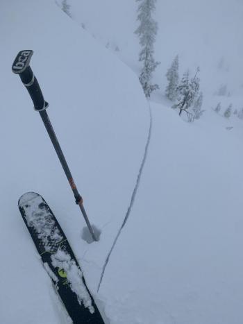
Take the time to secure your guylines if you are planning on camping above treeline. It's going to be wild ride. Strong to gale force northwest winds will continue to pummel the mountain. There is still snow being transported so you should pay attention on southerly and easterly slopes at high elevations. Blocking and cracking snow are indications that wind slabs are lurking nearby.
Forecast Discussion
A Level I avalanche course is being offered March 5-7 through College of the Siskiyous. Click here for more info.
Recent Observations
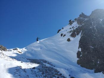
I don't know where it was coming from, but strong northerly winds were still blowing snow yesterday. There was snow in the air even at Red Fir Flats. You could see it miles away blowing over the Trinity Chutes and Red Banks -- mostly sublimating, though. It seems unlikely that fresh wind slabs were forming, but keep them in mind on south and east facing slopes at high elevations. Cornices are hard and will not budge even under extreme stomping.
Winds have been hilarious. They've been determined to blow you off your feet -- and have succeeded. Don't expect favorable conditions above treeline for anything.

Weather and Current Conditions
Weather Summary
You might get a cycle of spring skiing today with above freezing temperatures and partly sunny weather expected. Winds above treeline will probably keep snow surfaces mostly firm, though. Stick to open areas at lower elevations for the best sliding conditions. Northwest winds will increase throughout the day gaining gale force speeds tonight.
Some models are forecasting a bit of snow tonight and tomorrow but I'll have to see it to believe it. You can probably leave your powder boards at home.
24 Hour Weather Station Data @ 4:00 AM
| Weather Station | Temp (°F) | Wind (mi/hr) | Snow (in) | Comments | ||||||||
|---|---|---|---|---|---|---|---|---|---|---|---|---|
| Cur | Min | Max | Avg | Avg | Max Gust | Dir | Depth | New | Water Equivalent | Settlement | ||
| Mt. Shasta City (3540 ft) | 29 | 29 | 55 | 41 | 6 | |||||||
| Sand Flat (6750 ft) | 19 | 17 | 30 | 23 | 0 | 0 | 1 | Snow sensor down | ||||
| Ski Bowl (7600 ft) | 27.5 | 19.5 | 40 | 29 | 78.5 | 0 | 0 | 1 | ||||
| Gray Butte (8000 ft) | 29 | 20.5 | 35.5 | 28 | 14 | 67 | N | |||||
| Castle Lake (5870 ft) | 24 | 17.5 | 32.5 | 25 | 64.4 | 0 | 0 | |||||
| Mount Eddy (6509 ft) | 32 | 18 | 32 | 24 | 3 | 8 | WSW | 59.8 | 0 | 0.7 | ||
| Ash Creek Bowl (7250 ft) | 26.5 | 12 | 29.5 | 21.5 | 57.8 | 0 | 0.4 | |||||
| Ash Creek Ridge (7895 ft) | 29 | 8.5 | 29 | 19.5 | 5 | 26 | SSE |
Two Day Mountain Weather Forecast
Produced in partnership with the Medford NWS
| For 7000 ft to 9000 ft | |||
|---|---|---|---|
|
Thursday (4 a.m. to 10 p.m.) |
Thursday Night (10 p.m. to 4 a.m.) |
Friday (4 a.m. to 10 p.m.) |
|
| Weather | Partly sunny. | Mostly clear. Breezy. | Sunny. |
| Temperature (°F) | 40 | 21 | 34 |
| Wind (mi/hr) | Northwest 10-15 | Northwest 20-25 | Northwest 10-15 |
| Precipitation SWE / Snowfall (in) | 0.00 / 0 | 0.00 / 0 | 0.00 / 0 |
| For 9000 ft to 11000 ft | |||
| Thursday | Thursday Night | Friday | |
| Weather | Partly sunny. Windy. Low wind chills. | A 20 percent chance of snow showers. Mostly clear. Very windy. Low wind chills. | A slight chance of snow showers before 10 a.m., then a slight chance of snow showers after 4 p.m. Sunny. Windy. Low wind chills. |
| Temperature (°F) | 26 | 23 | 23 |
| Wind (mi/hr) | Northwest 35-45 | Northwest 55-65 | Northwest 45-55 |
| Precipitation SWE / Snowfall (in) | 0.00 / 0 | 0.00 / 0 | 0.00 / 0 |
Season Precipitation for Mount Shasta City
| Period | Measured (in) | Normal (in) | Percent of Normal (%) |
|---|---|---|---|
| From Oct 1, 2025 (the wet season) | 13.58 | 28.42 | 48 |
| Month to Date (since Jul 1, 2026) | 2.14 | 6.15 | 35 |
| Year to Date (since Jan 1, 2026) | 10.00 | 13.21 | 76 |

