

You are here
Avalanche Forecast for 2021-03-19 06:16
- EXPIRED ON March 20, 2021 @ 6:16 amPublished on March 19, 2021 @ 6:16 am
- Issued by Nick Meyers - Shasta-Trinity National Forest
Bottom Line
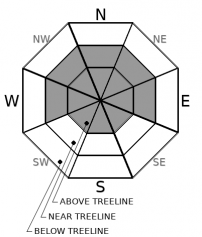
Over the past 24 hours, 4-8 inches of snow fell within the forecast area and combined with southerly wind. You may be able to trigger small avalanches where wind and snow has formed shallow drifts in steep terrain. These avalanches could be possible near and above treeline on Mt. Shasta, while conditions may be less dangerous elsewhere. Watch for continued wind loading if wind is present. Precipitation and wind will trend downward into the weekend.


Avalanche Problem 1: Wind Slab
-
Character ?

-
Aspect/Elevation ?
-
Likelihood ?CertainVery LikelyLikelyPossible
 Unlikely
 -
Size ?HistoricVery LargeLargeSmall

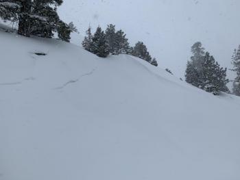
Keep an eye out for fresh drifts on leeward sides of ridges at upper elevations where southerly wind has been more active. Any wind slabs should be limited to small pockets within the terrain. If you find fresh drifts greater than 6 inches deep on steep, leeward slopes, these avalanches could be possible. Slabs could rest on soft snow or melt-freeze crusts. Continue to stay aware of cornice hazard along ridges.
Recent Observations
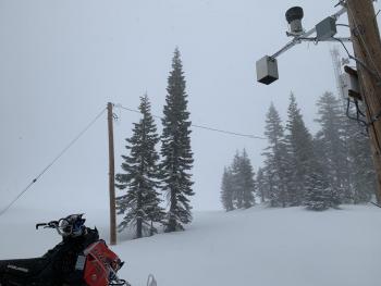
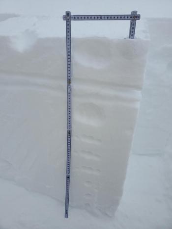
- The storm of the past 24 hours was under-whelming. Snow totals across the forecast area observed 4-6 inches on average and in some places up to 8 inches. Precipitation was on again/off again, mixed snow and freezing fog/mist, the kind that sticks to your goggles making skiing and/or riding difficult. Visibility was less than 1/8 mile and less than a couple feet when my goggles rimed up.
- The new snow was moist and decent to ski on lower angle terrain, but the old melt-freeze crust that formed over the past couple days this week was easily felt below. Northerly aspects probably still hold some softer snow.
- Southerly wind was overall light below and near treeline. Exposed terrain near treeline (ridges) and above treeline experienced higher wind speeds and some wind loading was observed on northwest slopes with slab like properties and minor cracking.
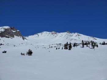
- Yesterday's observation from the mountain with photos is here. No major signs of avalanche danger were noted. Any instabilities are likely to be within the new storm snow.
Weather and Current Conditions
Weather Summary
Cooler, moist air pushes in with perhaps a few lingering showers across the area today. Most of these showers will be to the west, but some may make it east of the Cascades. This low pressure will move onshore Saturday morning and exit the region Saturday evening. Overall, precipitation and wind will be trending downwards into the weekend.
24 Hour Weather Station Data @ 3:00 AM
| Weather Station | Temp (°F) | Wind (mi/hr) | Snow (in) | Comments | ||||||||
|---|---|---|---|---|---|---|---|---|---|---|---|---|
| Cur | Min | Max | Avg | Avg | Max Gust | Dir | Depth | New | Water Equivalent | Settlement | ||
| Mt. Shasta City (3540 ft) | 38 | 35 | 41 | 38.5 | 5 | E | ||||||
| Sand Flat (6750 ft) | 25 | 25 | 33 | 29 | Snow sensor down | |||||||
| Ski Bowl (7600 ft) | 21 | 21 | 29 | 25 | 90.5 | 5.4 | 0.14 | 0 | ||||
| Gray Butte (8000 ft) | 20.5 | 20.5 | 27 | 24 | 15 | 43 | S | |||||
| Castle Lake (5870 ft) | 26.5 | 26.5 | 31.5 | 29 | 82.8 | 6.1 | 0 | |||||
| Mount Eddy (6509 ft) | 24 | 24 | 31.5 | 28 | 2 | 7 | SSW | 81.6 | 4.6 | 0 | ||
| Ash Creek Bowl (7250 ft) | 22.5 | 22.5 | 28 | 25.5 | 78.4 | 1.7 | 0 | |||||
| Ash Creek Ridge (7895 ft) | 19 | 19 | 25 | 22.5 | 0 | 0 | wind sensor rimed |
Two Day Mountain Weather Forecast
Produced in partnership with the Medford NWS
| For 7000 ft to 9000 ft | |||
|---|---|---|---|
|
Friday (4 a.m. to 10 p.m.) |
Friday Night (10 p.m. to 4 a.m.) |
Saturday (4 a.m. to 10 p.m.) |
|
| Weather | Mostly cloudy this morning, becoming partly cloudy. Lingering showers. Freezing level near town. | Partly to mostly cloudy, lingering showers. Freezing level near town. | Mostly sunny, slight chance of showers, freezing level near town. |
| Temperature (°F) | 25 | 16 | 30 |
| Wind (mi/hr) | South 5-10 | Southwest 5-10 | West 5-10 |
| Precipitation SWE / Snowfall (in) | 0.05 / 0-1 | 0.04 / 0-0.50 | 0.00 / 0 |
| For 9000 ft to 11000 ft | |||
| Friday | Friday Night | Saturday | |
| Weather | Snow showers, partly sunny, cold and windy. | Mostly cloudy, chance of showers, windy. | Mostly sunny and cold, windy. |
| Temperature (°F) | 9 | 5 | 8 |
| Wind (mi/hr) | Southwest 15-25 | Southwest 10-20 | Northwest 10-20 |
| Precipitation SWE / Snowfall (in) | 0.05 / 0-1 | 0.04 / 0-0.50 | 0.00 / 0 |
Season Precipitation for Mount Shasta City
| Period | Measured (in) | Normal (in) | Percent of Normal (%) |
|---|---|---|---|
| From Oct 1, 2025 (the wet season) | 17.13 | 33.55 | 51 |
| Month to Date (since Jul 1, 2026) | 3.55 | 4.05 | 88 |
| Year to Date (since Jan 1, 2026) | 13.55 | 18.34 | 74 |

