

You are here
Avalanche Forecast for 2021-03-21 06:40
- EXPIRED ON March 22, 2021 @ 6:40 amPublished on March 21, 2021 @ 6:40 am
- Issued by Ryan Sorenson - Mount Shasta Avalanche Center
Bottom Line
Avalanche danger is low. Spring sunshine will cause some snow surface melt today. Small wet loose avalanches on solar aspects are unlikely but not impossible. Continue to watch for wind slabs on isolated features in steep, extreme terrain.


Avalanche Problem 1: Normal Caution
-
Character ?

-
Aspect/Elevation ?
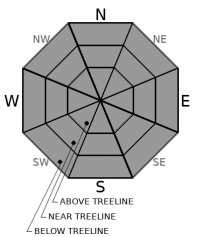
-
Likelihood ?CertainVery LikelyLikelyPossible
 Unlikely
 -
Size ?HistoricVery LargeLargeSmall

Use normal caution traveling in the backcountry today. Small wet loose avalanches on slopes with direct sun exposure are unlikely but not impossible. If you find yourself in ankle-deep wet snow, you may want to avoid steep slopes nearby.
Continue to watch for unstable wind slabs on isolated features in steep, extreme terrain at high elevations. Small, shallow and isolated wind slabs were seen on the upper mountain yesterday. With another day of warm temperatures and a cool night, these will be stubborn to trigger. Identify potential hazards as you travel and be prepared if something unexpected happens.
Forecast Discussion
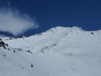
Scoured icy surfaces with patches of barley covered rocks present the hazard of a dangerous long sliding fall with many obstacles to hit. If attempting to climb, wear a helmet and use an ice axe and crampons. Know that self-arrest may be difficult to impossible on these steep icy slopes. Be willing to step back into safer terrain or rope up and place protection if conditions warrant.
Building clouds and low visibility is possible late this evening. Do not climb into a whiteout, carry navigation tools, and be prepared for winter-like conditions.
Recent Observations
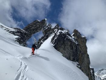
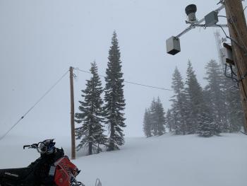
Yesterday was full of mixed clouds, sun, and beautiful filtered light. Very light snow showers would move in and out, followed by large sunny patches. Little to no accumulation was observed. The clouds formed near 8,000-9,000 feet on Mount Shasta with mixed storm clouds above and below. The wind was light and variable, with moderate gusts out of the north.
- Most areas hosted a widespread supportable melt-freeze (MF) crust with a dusting of powdery snow on top.
- Soft, old powdery snow still lingers on the coldest northerly aspects.
- Snow surfaces were becoming moist and heavy in the afternoon due to warming temperatures. More melt-freeze (MF) crusts likely formed last night.
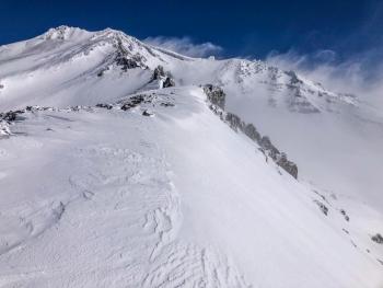
- Sun and wind crusts become more supportable at higher elevations on Mount Shasta.
- More snow exists in gullies, depressions, and on leeward slopes.
- Winds have scoured areas down to the rocks and old crusty snow across the West Face and Casaval Ridge.
- Rime, ice, and small wind-sculpted features were observed above 9,000 feet on Casaval Ridge.
- Small Isolated wind slabs were encountered but not widespread and did not display significant cracking/instability.
- Overall, no major signs of unstable snow.
Weather and Current Conditions
Weather Summary
A ridge of high pressure has built over southern Oregon and northern California. Expect sunny skies with light winds out of the northwest.
There is a chance for light snow showers to spill into the area after midnight as a cold front moves through the southern Oregon Cascades. This will cause partly cloudy skies and colder temperatures tomorrow. Snow levels will be near 4,500 feet. Little snow accumulation is expected. High pressure and sun will return on Tuesday.
24 Hour Weather Station Data @ 5:00 AM
| Weather Station | Temp (°F) | Wind (mi/hr) | Snow (in) | Comments | ||||||||
|---|---|---|---|---|---|---|---|---|---|---|---|---|
| Cur | Min | Max | Avg | Avg | Max Gust | Dir | Depth | New | Water Equivalent | Settlement | ||
| Mt. Shasta City (3540 ft) | 31 | 31 | 48 | 39 | 2 | N | ||||||
| Sand Flat (6750 ft) | 13 | 13 | 32 | 22 | 0 | 0 | 0 | 0 | Snow sensor down | |||
| Ski Bowl (7600 ft) | 18.5 | 14 | 28 | 21.5 | 86.8 | 0 | 0.56 | 2.2 | ||||
| Gray Butte (8000 ft) | 17 | 15.5 | 28.5 | 20.5 | 5 | 31 | NW | |||||
| Castle Lake (5870 ft) | 21.5 | 21 | 42 | 27 | 76.5 | 0 | 3.5 | |||||
| Mount Eddy (6509 ft) | 21.5 | 19.5 | 30 | 24 | 2 | 6 | SE | 78.2 | 0 | 2 | ||
| Ash Creek Bowl (7250 ft) | 15.5 | 15.5 | 27.5 | 21 | 76.9 | 0 | 1 | |||||
| Ash Creek Ridge (7895 ft) | 12.5 | 12.5 | 20 | 17 | 0 | 0 | wind sensor rimed |
Two Day Mountain Weather Forecast
Produced in partnership with the Medford NWS
| For 7000 ft to 9000 ft | |||
|---|---|---|---|
|
Sunday (4 a.m. to 10 p.m.) |
Sunday Night (10 p.m. to 4 a.m.) |
Monday (4 a.m. to 10 p.m.) |
|
| Weather | Sunny. | Mostly cloudy. A slight chance of snow showers after midnight. | Partly cloudy. Chance of snow showers. Snow levels near 4,500 feet. |
| Temperature (°F) | 37 | 25 | 34 |
| Wind (mi/hr) | North 5-10 | Northwest 5-10 | Northwest 5-10 |
| Precipitation SWE / Snowfall (in) | 0.00 / 0 | 0.01 / 0-0.50 | 0.00 / 0-0.50 |
| For 9000 ft to 11000 ft | |||
| Sunday | Sunday Night | Monday | |
| Weather | Sunny. | Mostly cloudy. A slight chance of snow showers after midnight. | Partly cloudy. Chance of snow showers. |
| Temperature (°F) | 21 | 16 | 17 |
| Wind (mi/hr) | North 10-20 | Northwest 20-30 | Northwest 30-40 |
| Precipitation SWE / Snowfall (in) | 0.00 / 0 | 0.01 / 0-0.50 | 0.00 / 0-0.50 |
Season Precipitation for Mount Shasta City
| Period | Measured (in) | Normal (in) | Percent of Normal (%) |
|---|---|---|---|
| From Oct 1, 2025 (the wet season) | 17.13 | 33.88 | 51 |
| Month to Date (since Jun 1, 2026) | 3.55 | 4.38 | 81 |
| Year to Date (since Jan 1, 2026) | 13.55 | 18.67 | 73 |

