

You are here
Avalanche Forecast for 2021-04-07 06:00
- EXPIRED ON April 8, 2021 @ 6:00 amPublished on April 7, 2021 @ 6:00 am
- Issued by Aaron Beverly - Mount Shasta Avalanche Center
Bottom Line
Avalanche danger is low. Falling rock and slips and falls are the main concern. Be mindful of loose wet avalanches and cornice breaks during the warmest hours of the day.


Avalanche Problem 1: Normal Caution
-
Character ?

-
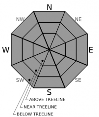
Aspect/Elevation ?
-
Likelihood ?CertainVery LikelyLikelyPossible
 Unlikely
 -
Size ?HistoricVery LargeLargeSmall

Normal caution is advised in the backcountry. The spring climbing season is here. Falling rock and slips and falls are the main concern. Keep your head up and helmet on and use your ice axe and crampons.
Warm spring sunshine will melt snow surfaces and loose wet avalanches or cornice breaks are not impossible. Do you see rollerballs and pinwheels? Are you sinking up to your ankles? If so, avoid overhanging cornices and steep slopes.
Forecast Discussion
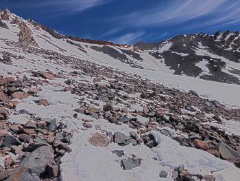
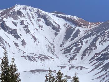
We've had dry winter. Precipitation is 48% of normal. High wind events have left the upper mountain scoured and rocky. Climbs this season will have more risk than normal. The optimal climbing season has been pushed months earlier this year. If you plan to climb the south side of Mount Shasta, now is the time. The climbing routes around The Heart and through the Red Banks in Avalanche Gulch are already narrow or melted out.
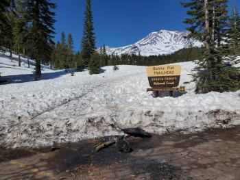
The Bunny Flat trailhead is the only open trailhead accessible by vehicle at this time. Except for Bunny Flat, all summit passes, wilderness permits, and human waste packout bags must be attained at the McCloud or Mount Shasta Ranger Stations (self-issue) or at The Fifth Season in Mount Shasta.
Recent Observations
With a positive attitude, you will still find some good skiing out there. A couple of travelers summitted yesterday and skied from the climber's left of the heart below Red Banks, the same route they climbed on. Boot and ski tracks, sastrugis, and sun cups have made finding smooth conditions more difficult, but not impossible. Look for the best sliding conditions below 10,000 ft. Expect survival skiing above. Snow surfaces are firming up nicely for an early morning summit attempt. But a few rocks are falling at the wee hours, so stay vigilant.
Rollerballs and pinwheels were not observed above treeline yesterday in Avalanche Gulch. No signs of loose wet avalanches were seen.
Sand Flat still has plenty of snow for the horizontal shuffle. Trails are a bit rough, but good enough.
Over the past 24 hours, near treeline winds have been light. Temperatures peaked at 48 ºF and bottomed out at 30. The snow depth at the Old Ski Bowl is 68 in, 1.6 inches less than yesterday morning.

Weather and Current Conditions
Weather Summary
Winds will gradually switch from south to north over the next 24 hours and will pick up speed. The cycle of melt-freeze will continue ad nauseam. These spring conditions have some excited and others despairing. The only thing to do is to take advantage. Fire up those barbecues and plant those gardens. Dust off your mountain bikes. Get out side and enjoy.
24 Hour Weather Station Data @ 4:00 AM
| Weather Station | Temp (°F) | Wind (mi/hr) | Snow (in) | Comments | ||||||||
|---|---|---|---|---|---|---|---|---|---|---|---|---|
| Cur | Min | Max | Avg | Avg | Max Gust | Dir | Depth | New | Water Equivalent | Settlement | ||
| Mt. Shasta City (3540 ft) | 46 | 46 | 49 | |||||||||
| Sand Flat (6750 ft) | 35 | 27 | 54 | 40 | 0 | 0 | Snow sensor down | |||||
| Ski Bowl (7600 ft) | 32 | 29.5 | 48 | 39.5 | 68.2 | 0 | 0 | 1.6 | ||||
| Gray Butte (8000 ft) | 31 | 31 | 44.5 | 37.5 | 6 | 31 | W | |||||
| Castle Lake (5870 ft) | 37 | 35 | 61 | 46.5 | 57.5 | 0 | 1.6 | |||||
| Mount Eddy (6509 ft) | 36.5 | 29.5 | 50.5 | 41.5 | 2 | 5 | WSW | 58 | 0 | 0.4 | ||
| Ash Creek Bowl (7250 ft) | 33 | 14 | 33 | 23.5 | 69.4 | 0 | 0.5 | |||||
| Ash Creek Ridge (7895 ft) | 31.5 | 31.5 | 49 | 39 | 6 | 28 | S |
Two Day Mountain Weather Forecast
Produced in partnership with the Medford NWS
| For 7000 ft to 9000 ft | |||
|---|---|---|---|
|
Wednesday (4 a.m. to 10 p.m.) |
Wednesday Night (10 p.m. to 4 a.m.) |
Thursday (4 a.m. to 10 p.m.) |
|
| Weather | Patchy fog before 11 a.m. Otherwise, mostly cloudy, then gradually becoming sunny. | Mostly clear. | Sunny. |
| Temperature (°F) | 46 | 26 | 42 |
| Wind (mi/hr) | South 5-10 | West 5-10 | Northwest 5-10 |
| Precipitation SWE / Snowfall (in) | 0.00 / 0 | 0.00 / 0 | 0.00 / 0 |
| For 9000 ft to 11000 ft | |||
| Wednesday | Wednesday Night | Thursday | |
| Weather | Patchy fog before 11 a.m. Otherwise, mostly cloudy, then gradually becoming sunny. | Mostly clear. Breezy. Low wind chills. | Sunny. Windy. Low wind chills. |
| Temperature (°F) | 26 | 24 | 30 |
| Wind (mi/hr) | Southwest 15-20 | West 20-25 | Northwest 30-35 |
| Precipitation SWE / Snowfall (in) | 0.00 / 0 | 0.00 / 0 | 0.00 / 0 |
Season Precipitation for Mount Shasta City
| Period | Measured (in) | Normal (in) | Percent of Normal (%) |
|---|---|---|---|
| From Oct 1, 2025 (the wet season) | 17.15 | 36.16 | 47 |
| Month to Date (since Jul 1, 2026) | 0.00 | 0.70 | 0 |
| Year to Date (since Jan 1, 2026) | 13.57 | 20.95 | 65 |

