-
EXPIRED ON January 27, 2018 @ 6:40 amPublished on January 26, 2018 @ 6:40 am
-
Issued by
Nick Meyers - Shasta-Trinity National Forest
The avalanche danger is LOW below treeline and MODERATE near and above treeline. The wind slab avalanche problem remains a concern due to strong winds expected near and above treeline on Mount Shasta. Human triggered avalanches are possible in steep, freshly wind loaded terrain on NE-E-SE facing aspects. Rime ice is plastered to exposed rocks. Wear a helmet.
Heightened avalanche conditions on specific terrain features. Evaluate snow and terrain carefully; identify features of concern.
Heightened avalanche conditions on specific terrain features. Evaluate snow and terrain carefully; identify features of concern.
Generally safe avalanche conditions. Watch for unstable snow on isolated terrain features.
Forecast Hotline: (530) 926-9613
Below Treeline is the lowest of three elevation bands used in the advisories. It extends from valley floors or snowline to Near Treeline. Open areas and sparse trees are possible. Snowfall tends to be less than the other elevation bands. Tree cover shelters the snow from wind effects.
×Near Treeline is the middle of the three elevation bands used in the advisories. It is a transition zone between dense forests and treeless alpine areas. It is the narrowest of the three elevation bands, extending only a few hundred feet above and below the treeline. It varies locally, and is not a constant elevation or width.
×Above Treeline is the highest of the three elevation bands used in the advisories. It includes alpine areas where the most snow falls and the winds are the strongest. It is not an exact elevation, but a characteristic of the terrain, beginning as the treeline transitions into open slopes extending to ridges and the tops of the highest peaks.
×North American Avalanche Danger Scale
Avalanche danger is determined by the likelihood, size and distribution of avalanches.
Watch for signs of unstable snow such as recent avalanches, cracking in the snow, and audible collapsing. Avoid traveling on or under similar slopes.
Safe backcountry travel requires training and experience. You control your own risk by choosing where, when and how you travel.
North American Avalanche Danger Scale
Avalanche danger is determined by the likelihood, size and distribution of avalanches.
Generally safe avalanche conditions. Watch for unstable snow on isolated terrain features.
Natural and human-triggered avalanches unlikely.
Small avalanches in isolated areas or extreme terrain.
Safe backcountry travel requires training and experience. You control your own risk by choosing where, when and how you travel.
North American Avalanche Danger Scale
Avalanche danger is determined by the likelihood, size and distribution of avalanches.
Heightened avalanche conditions on specific terrain features. Evaluate snow and terrain carefully; identify features of concern.
Natural avalanches unlikely; human-triggered avalanches possible.
Small avalanches in specific areas; or large avalanches in isolated areas.
Safe backcountry travel requires training and experience. You control your own risk by choosing where, when and how you travel.
North American Avalanche Danger Scale
Avalanche danger is determined by the likelihood, size and distribution of avalanches.
Dangerous avalanche conditions. Careful snowpack evaluation, cautious route-finding and conservative decision making essential.
Natural avalanches possible; human triggered avalanches likely.
Small avalanches in many areas; or large avalanches in specific areas; or very large avalanches in isolated areas.
Safe backcountry travel requires training and experience. You control your own risk by choosing where, when and how you travel.
North American Avalanche Danger Scale
Avalanche danger is determined by the likelihood, size and distribution of avalanches.
Very dangerous avalanche conditions. Travel in avalanche terrain not recommended.
Natural avalanches likely; human-triggered avalanches very likely.
Large avalanches in many areas; or very large avalanches in specific areas.
Safe backcountry travel requires training and experience. You control your own risk by choosing where, when and how you travel.
North American Avalanche Danger Scale
Avalanche danger is determined by the likelihood, size and distribution of avalanches.
Avoid all avalanche terrain.
Natural and human-triggered avalanches certain.
Large to very large avalanches in many areas.
Safe backcountry travel requires training and experience. You control your own risk by choosing where, when and how you travel.
Weather and Current Conditions
Disclaimer
This advisory does not apply to Ski Areas or Highways and is for the Mount Shasta, Castle Lake and Mount Eddy backcountry. Use this information for guidance only. You may find different conditions in the backcountry and should travel accordingly. This advisory expires on midnight of the date it was posted unless otherwise noted.


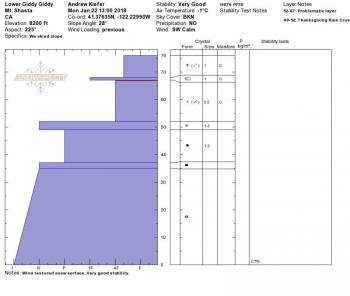


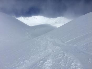
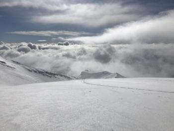
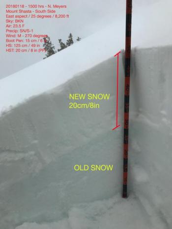
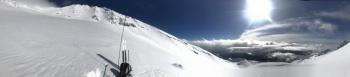
Storm totals of 10-15cm (4-6in) were confirmed during a tour to lower Giddy Giddy Gulch. The new snow had settled 3-5cm (1-2in) by early afternoon today. No recent avalanches were observed nor were any obvious signs of instability. Wind slabs were hard to find near and above treeline. Above 8000ft, wind textured snow surfaces were widespread. Above treeline, minor wind loading was visible in terrain above 10,000ft. Exposed terrain features were scoured down to a slick icy old snow surface. By early afternoon, a zipper sun crust was already staring to form on the snow surface on steep, open south facing slopes.
Overall, snowpack stability was good in the terrain observed. Compression tests produced no fractures. A density break exists within the 1/19 storm snow – it can be found about 15-20cm down from the snow surface in most locations. For the time being, not enough of a cohesive slab sits on top of this layer to cause concern.